Ramgarh is a census town and corresponding community development block in Kaimur district of Bihar, India. As of 2011, its population was 8,690, in 1,345...
12 KB (561 words) - 01:25, 16 May 2024

Ramgarh Assembly constituency is one of 243 constituencies of legislative assembly of Bihar. It comes under Buxar Lok Sabha constituency. Ramgarh comprises...
6 KB (111 words) - 08:58, 29 June 2024
Kaimur district is one of the 38 districts of Bihar, India. The district headquarters are at Bhabua. Before 1991, it was part of Rohtas District. Till...
16 KB (1,378 words) - 06:22, 1 July 2024
dictionary. Ramgarh may refer to: Ramgarh Upazila, a sub-district of Khagrachari District Ramgarh, Bihar, a village near Munger, Bihar Ramgarh, Kaimur, a town...
2 KB (282 words) - 22:05, 28 July 2023
spelled Baidyanath, is a village in Ramgarh block of Kaimur district, Bihar, India. Located 9 km south of Ramgarh, it is the site of an old Shiva temple...
3 KB (89 words) - 01:25, 16 May 2024

Ramgarh is 4th Most Developed City of Kaimur District in Bihar. It is 30 KM North to District Head Quarter Bhabua And 15 KM from District Sub Head Quarter...
845 bytes (76 words) - 19:35, 4 August 2024
Mohania (redirect from Mohania, Kaimur, Bihar)
community development block in Kaimur district of Bihar, India. It serves as headquarters for the Mohania sub-division in Kaimur district. It is 17 km (11 mi)...
18 KB (695 words) - 05:27, 19 April 2024

Brahampur Buxar (4) 33 Buxar 200 Buxar 201 Dumraon 202 Rajpur (SC) 203 Ramgarh Kaimur (4) 204 Mohania (SC) 34 Sasaram 205 Bhabua 206 Chainpur 207 Chenari...
25 KB (230 words) - 17:35, 18 March 2024
Bhagwanpur is a village and corresponding community development block in Kaimur district of Bihar, India. As of 2011, its population was 6,213, in 1,081...
10 KB (308 words) - 01:25, 16 May 2024
Buxar Lok Sabha constituency (category Politics of Kaimur district)
Ajit Kushwaha CPIML BJP 202 Rajpur (SC) Vishwanath Ram INC BJP 203 Ramgarh Kaimur Sudhakar Singh RJD BJP 210 Dinara Rohtas Vijay Kumar Mandal RJD BJP...
11 KB (192 words) - 14:00, 1 July 2024

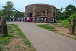
Mundesvari) is a Hindu temple, located at Ramgarh Village, 608 feet (185 m) on the Mundeshwari Hills of Kaimur plateau near Son River, in the Indian state...
15 KB (1,379 words) - 12:33, 14 July 2024
Canal located in Kaimur District of Bihar, India. It arises from Kohira River in Chainpur tehsil and ends in Ramgarh Tehsil of Kaimur at Durgawati River...
4 KB (108 words) - 16:48, 27 July 2024
community development block in Kaimur district of Bihar, India. It is located 11km west of Bhabua, the district headquarters of kaimur district .As of 2011, the...
11 KB (463 words) - 14:16, 25 May 2024

Bhabua Road railway station (category Railway stations in Kaimur district)
the Grand Trunk Road. It has five platforms. It is a B Grade station in Kaimur district recognised by Railway of India. As of 2022, over 70+ trains from...
10 KB (240 words) - 13:06, 31 July 2024
Pradesh-Bihar border and will enter through Kaimur district of Bihar. It will cross the state through the districts of Kaimur, Aurangabad, Rohtas and Gaya. The...
23 KB (1,925 words) - 06:00, 31 May 2024

Darbhanga district Mittheswarnath Shiv Temple, Chunabhatti Kaimur district Mundeshwari Temple, Ramgarh Lakhisarai district Ashokdham Temple Madhubani district...
22 KB (977 words) - 09:17, 5 August 2024
Durgavati Canal (category Kaimur district)
known as Kudra Wier Canal or Kudra Project Canal, is a canal located in Kaimur District in Bihar (India). During the British Raj, after Punjab and Agra...
8 KB (524 words) - 16:56, 27 July 2024
Durgawati (category Cities and towns in Kaimur district)
(also called Durgaoti or Durgauti) is a community development block in Kaimur district in Indian state of Bihar . It is geographically located between...
13 KB (726 words) - 05:23, 17 February 2024
the state. Its jurisdiction extends over four districts, Bhojpur, Buxar, Kaimur and Rohtas. Sumitra Mahila College Dumraon K.K Mandal College Buxar P.C...
4 KB (361 words) - 12:50, 5 August 2024
Bhabua (category Cities and towns in Kaimur district)
(spelled as Bhabua) is a Holy Land And Sacred City of Maa Mundeshwari in Kaimur District under Bihar State. At Peak of Paunra Mountain, The Goddess AdiShakti...
6 KB (620 words) - 21:00, 4 August 2024
a region of 32 places around Karamnasa river in Ghazipur district, and Kaimur District of Uttar Pradesh, , India. Of whom main mouzas being 19. It is...
9 KB (739 words) - 07:29, 10 August 2024

Sanctuary, 1976 Pant Wildlife Sanctuary, 1978 Udaypur Wildlife Sanctuary, 1978 Kaimur Wildlife Sanctuary, 1982 Nagi Dam Wildlife Sanctuary, 1987 Nakti Dam Wildlife...
30 KB (2,163 words) - 09:04, 3 August 2024
Bhagalpur Bhojpur Buxar Darbhanga East Champaran Gaya Gopalganj Jamui Jehanabad Kaimur (Bhabhua) Katihar Khagaria Kishanganj Lakhisarai Madhepura Madhubani Munger...
30 KB (882 words) - 00:54, 8 January 2024
Mapatpur (category Villages in Kaimur district)
Mapatpur is a small village in Nuaon Tehsil in Ramgarh Block in Kaimur district of the Indian state of Bihar. It comes under the Panchayat raj political...
1 KB (150 words) - 19:47, 14 November 2023
Durgawati Tehsil to the south. Gaighat is on the border of the Ghazipur, Kaimur, and Chandauli districts. It is also near the Karamnasha and Ganga rivers...
4 KB (350 words) - 11:19, 27 September 2023

Bansagar Dam Indrapuri Barrage Rihand Dam Geographical features Maikal Hills Kaimur Range Chota Nagpur Plateau Riparian districts Languages/people Baiga Gondi...
7 KB (660 words) - 22:43, 27 February 2024
the lower Ganga plain in East and from the Madhesh region in north to the Kaimur Range and Chota Nagpur Plateau in south. At its peak of reign, the Chero/Chyavana...
20 KB (2,578 words) - 05:41, 11 June 2024

the Raja of Ramgarh was the most powerful hill chieftain, and making alliance with several other rulers he took over the fortress of Ramgarh. The Raja offered...
18 KB (1,568 words) - 12:08, 29 July 2024

would vote from 7:00 to 17:00: Brahampur, Buxar, Dumraon, Rajpur (SC), Ramgarh, Mohania (SC), Kargahar, Nokha, Obra, Aurangabad The following constituencies...
85 KB (2,577 words) - 09:51, 21 July 2024

Thakurganj 1,690,400 1,884 687 17 KM Kaimur Bhabua Adhaura Bhabua Bhagwanpur Chainpur Chand Durgawati Kudra Mohania Nuaon Ramgarh Rampur 1,626,384 3,363 382 18...
17 KB (150 words) - 15:07, 7 July 2024