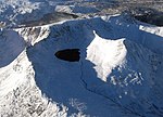
arêtes. The middle of these coves contains Red Tarn. Like much of the main ridge of the range, Helvellyn stands on the watershed between Thirlmere and...
56 KB (6,778 words) - 21:36, 29 July 2024

flank of Helvellyn, beneath Striding Edge and Catstye Cam. Red Tarn was formed when the glacier that carved out the eastern side of Helvellyn had melted...
3 KB (214 words) - 03:22, 20 April 2022
Bridge Red Tarn (Helvellyn), below the summit of Helvellyn Red Tarn (Langdale), between Cold Pike and Pike of Blisco Rydal Water Scales Tarn, below the summit...
33 KB (1,299 words) - 16:28, 17 February 2023
South of Catstye Cam, nestling between the encircling arms of Helvellyn's two edges, is Red Tarn. This pool is named for the colour of the surrounding screes...
7 KB (850 words) - 00:09, 10 July 2023

alive again. Three months later on 27 July a shepherd heard barking near Red Tarn, and on investigating, discovered Foxie beside the body of her master....
7 KB (731 words) - 04:32, 8 December 2022

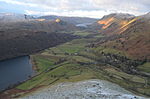
Helvellyn's Red Tarn to form Glenridding Beck, flowing on through the village to Ullswater. The western slopes of White Side are bounded by Helvellyn...
6 KB (740 words) - 11:36, 24 June 2023
Fell, Mardale Hartsop above How Hartsop Dodd Haycock Haystacks Helm Crag Helvellyn Hen Comb Heron Pike High Crag High Hartsop Dodd High Pike (Scandale) High...
23 KB (2,842 words) - 18:49, 25 May 2024

ridge. Red Tarn Beck forms the western perimeter of Birkhouse Moor, draining the large tarn of that name nestling beneath the summit of Helvellyn. There...
5 KB (709 words) - 07:09, 22 April 2024

Fairfield (Lake District) (section Grisedale Tarn)
Sandal, or by cutting across the outlet of Grisedale Tarn from Dollywaggon Pike and the Helvellyns. In this way Fairfield forms part of the Threlkeld–Kirkstone...
7 KB (925 words) - 21:01, 21 August 2022

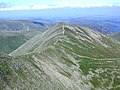
stands on the main spine of the Helvellyn range in the Eastern Fells, between Thirlmere and Ullswater. The Helvellyn range runs broadly north–south for...
7 KB (1,013 words) - 11:14, 24 June 2023
to Helvellyn. Other fells that can be reached from the valley include Place Fell, High Street, Glenridding Dodd, most of the peaks in the Helvellyn range...
6 KB (587 words) - 12:10, 29 April 2024

centred around Helvellyn and primarily consist of a north-south ridge running between Ullswater and Lakeland's Central Valley. Helvellyn, 950 m (3,117 ft)...
66 KB (2,878 words) - 15:00, 12 April 2024

or fells, include England's highest: Scafell Pike (978 m (3,209 ft)), Helvellyn (950 m (3,120 ft)) and Skiddaw (931 m (3,054 ft)). The region also contains...
96 KB (9,775 words) - 01:23, 30 June 2024

death of Charles Gough, who fell from Striding Edge, Helvellyn in 1805. His body found below Red Tarn some months later by a shepherd, his body still being...
17 KB (2,297 words) - 23:00, 17 June 2024

were built to regulate the flow of water in these becks, and natural tarns at Red Tarn and in Keppel Cove were augmented. After 1890, water power from the...
103 KB (16,039 words) - 16:29, 28 June 2024

obstructed by higher ground southward there is an end to end view of the Helvellyn range above Angletarn Pikes. The route from Martindale to the summit follows...
5 KB (574 words) - 23:53, 10 November 2023

Striding Edge, an arête viewed from Helvellyn with the corrie Red Tarn to the left and Nethermost Cove to the right...
5 KB (515 words) - 00:10, 19 April 2024

List of hill passes of the Lake District (redirect from Floutern Tarn Pass)
from Braithwaite. Styhead Tarn is at 440 metres (1,440 ft) and a short ascent reaches Sty Head Only the Windy Gap to Styhead Tarn section is called Aaron...
46 KB (2,578 words) - 13:59, 8 January 2024

Adjacent to that is a circular stone shelter. A few yards to the south is Red Screes Tarn, a small permanent waterbody with no plant life in evidence. A number...
16 KB (2,085 words) - 23:17, 5 February 2024

Wainwright offers a choice of three routes: via either of the mountains of Helvellyn or St Sunday Crag, or an easier descent along the valley of Grisedale...
15 KB (1,756 words) - 13:25, 11 January 2024

by the equally extensive Lincombe Tarns Tuff Formation, which is an ignimbrite. The uppermost part is the Helvellyn Basin succession, consisting of volcaniclastic...
42 KB (5,024 words) - 00:00, 18 December 2023

Fell Helvellyn High Street Hutton Roof Crags Lambrigg Fell Little Mell Fell Place Fell Red Screes St Sunday Crag Seat Sandal Stony Cove Pike Tarn Crag...
9 KB (892 words) - 13:13, 17 March 2023

other direction. There are also more distant glimpses of the Skiddaw and Helvellyn ranges. A path of sorts ascends direct from the village of Wasdale Head...
8 KB (1,053 words) - 04:55, 21 August 2023

such as rivers (Kent, Eden, Ehen, Levens) and mountains (Blencathra, Helvellyn, Coniston Old Man). In the first millennium AD the Brythonic spoken in...
23 KB (2,942 words) - 10:25, 1 May 2024

English Lake District. It marks the northern end of the main ridge of the Helvellyn range and is often walked as part of the ridge walk. The fell stands south...
22 KB (2,856 words) - 08:05, 3 September 2023

can also be seen from many points in the Lake District, including the Helvellyn summit, and from high ground throughout Dumfriesshire and Northumberland...
8 KB (827 words) - 15:55, 10 March 2024

56.963543769582;-4.1133474149124 NN716878] Ma,M,Sim 168 56 England 2 2 Helvellyn 950 712 3,117 2,336 34C 90 54.526890165364;-3.0182022417055 NY342151]...
311 KB (1,860 words) - 20:29, 19 July 2024
Fell Helvellyn High Street Hutton Roof Crags Lambrigg Fell Little Mell Fell Place Fell Red Screes St Sunday Crag Seat Sandal Stony Cove Pike Tarn Crag...
1 KB (47 words) - 22:01, 20 December 2023
Hill H RH Grid ref. Helvellyn 950 712 NY342151 Catstye Cam 890 63 NY348158 Raise 883 91 NY342174 White Side 863 42 NY337166 Dollywagon Pike 858 50 NY346130...
27 KB (182 words) - 11:14, 11 November 2023
series, broadcast in 2007, included Catbells, Crinkle Crags, Helm Crag, Helvellyn from Patterdale, High Street from Mardale and Pillar. A six-part series...
34 KB (3,613 words) - 15:27, 23 June 2024