A7 motorway (Netherlands) (redirect from Rijksweg 7)
is used in the Netherlands. The A7 together with the N7 is called the Rijksweg 7. From March 2011, on a section of the A7 motorway, motorists were allowed...
16 KB (455 words) - 16:41, 10 May 2023

A10 motorway (Netherlands) (redirect from Rijksweg 10)
The A10 motorway (Dutch: Rijksweg 10) is a motorway in the Netherlands. This motorway is the ring road around the city of Amsterdam. It has a length of...
7 KB (428 words) - 03:46, 25 August 2023

nieuwe verbindingsweg, Rijkswaterstaat Archived July 24, 2008, at the Wayback Machine (in Dutch) Wikimedia Commons has media related to Rijksweg 13....
5 KB (227 words) - 05:19, 20 March 2023

A8 motorway (Netherlands) (redirect from Rijksweg 8)
Uitgeest of the A9 motorway. However, the N8 is not part of the so-called Rijksweg 8, which only consists of the motorway part between the Coenplein and Assendelft...
4 KB (257 words) - 13:07, 25 July 2024

A50 motorway (Netherlands) (redirect from Rijksweg 50)
A50, the section of Rijksweg 50 that is constructed as controlled-access highway, is a north–south motorway in the Netherlands, running from Eindhoven...
11 KB (354 words) - 22:11, 14 December 2022

A1 motorway (Netherlands) (redirect from Rijksweg 1)
Wegenlijst RWS" [Up to date road list] (in Dutch). Rijkswaterstaat. 1 July 2015. Retrieved 17 February 2018. Media related to Rijksweg 1 at Wikimedia Commons...
9 KB (177 words) - 22:44, 17 July 2022

A2 motorway (Netherlands) (redirect from Rijksweg 2)
this section to 2x3 lanes started on December 13, 2011. Wikimedia Commons has media related to Rijksweg 2. "Wegbeheerders". Rijkswaterstaat. Retrieved...
21 KB (747 words) - 09:31, 27 September 2023

N48 motorway (Netherlands) (redirect from Rijksweg 48)
The rijksweg N48 is a Dutch expressway, managed by Rijkswaterstaat between the A28 and A37 motorways near Hoogeveen and the N340 and N36 just north of...
2 KB (71 words) - 09:34, 8 August 2024

A5 motorway (Netherlands) (redirect from Rijksweg 5)
entire route is in North Holland Province. Media related to Rijksweg 5 at Wikimedia Commons Wikimedia Commons has media related to Rijksweg 5. Wegenwiki...
5 KB (447 words) - 12:00, 27 January 2021
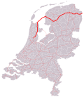
A12 motorway (Netherlands) (redirect from Rijksweg 12)
demand the end of fossil subsidies. Wikimedia Commons has media related to Rijksweg 12. ad.nl "Politie beëindigt blokkade A12 van Extinction Rebellion". nos...
12 KB (355 words) - 14:03, 30 September 2023

A28 motorway (Netherlands) (redirect from Rijksweg 28)
section of the A28 is the complete E232 route; the E232 does not consist of any other road or section. Media related to Rijksweg 28 at Wikimedia Commons...
12 KB (293 words) - 23:58, 15 February 2023

A79 motorway (Netherlands) (redirect from Rijksweg 79)
must local roads. No European routes follow the A79 motorway. The entire route is in Limburg Province. Media related to Rijksweg 79 at Wikimedia Commons...
3 KB (103 words) - 22:41, 22 July 2021

A4 motorway (Netherlands) (redirect from Rijksweg 4)
The A4 motorway, also called Rijksweg 4, is a motorway in the Netherlands running southwards from Amsterdam to the Belgian border near Zandvliet, north...
35 KB (3,377 words) - 14:04, 30 July 2024

A6 motorway (Netherlands) (redirect from Rijksweg 6)
either direction, and was forced to use the A1 and A27 motorways instead, a detour of about 20 kilometers. Media related to Rijksweg 6 at Wikimedia Commons...
7 KB (251 words) - 09:09, 20 March 2024

A15 motorway (Netherlands) (redirect from Rijksweg 15)
The Dutch A15 motorway (Rijksweg 15) is a set of two motorways in the Netherlands, the A15 and the A18. In governmental plans, the A15 and A18 together...
13 KB (558 words) - 15:50, 27 July 2023
(Morocco) National Highway 1 (Myanmar) A1 road (Namibia) Mahendra Highway Rijksweg 1 New Zealand State Highway 1 New Zealand State Highway 1B New Zealand...
20 KB (1,281 words) - 22:26, 13 August 2024

van het Noorden (in Dutch). 29 November 1968. Retrieved 2 March 2022. "Rijksweg A7 telt nu vier in plaats van twee rijstroken". Nederlands dagblad (in...
11 KB (813 words) - 18:22, 8 December 2023

borrow pit, caused by excavations for Almere Haven and is situated north of Rijksweg 6. Because these excavations caused a new body of water to form, within...
4 KB (235 words) - 12:36, 26 October 2023
example, the municipality of Roermond was not very glad when the tunnel on Rijksweg 73 was blocked. The sixth season starting airing on 27 January 2012 with...
17 KB (1,079 words) - 13:25, 22 July 2024

Retrieved 13 April 2022. "Postcodetool for 5321GA". Actueel Hoogtebestand Nederland (in Dutch). Het Waterschapshuis. 24 July 2019. Retrieved 13 April 2022...
5 KB (337 words) - 19:27, 3 October 2022

church. The tower of the old church remained. Railway Station: Gaanderen Rijksweg Doetinchem - Terborg Hoofdstraat 62, church Rekhemseweg 175 Kerkstraat...
4 KB (148 words) - 15:58, 13 April 2022

(Ring Den Haag) towards Scheveningen. Media related to Rijksweg 44 at Wikimedia Commons Wikimedia Commons has media related to Rijksweg 44. Wegenwiki, A44...
4 KB (362 words) - 19:27, 30 November 2021
Wielen, east of the Rijksweg 2, the highway from Maastricht to Amsterdam. Rosmalen Noord is 1503 hectare big and counts over 13.600 citizens. Rosmalen...
1 KB (119 words) - 06:22, 20 September 2021

Kleinpolderplein and Terbregseplein, just north of Rotterdam. The entire route is in South Holland. Media related to Rijksweg 20 at Wikimedia Commons...
4 KB (185 words) - 05:21, 20 March 2023

(Provinciale Weg) / Rijksweg West / Rijksweg Oost / Knijpslaan – Hoogezand, Slochteren 42 Sappemeer Noordbroeksterstraat / Rijksweg oost Menterwolde 43...
34 KB (2,058 words) - 22:47, 22 July 2021

July 2022. To these data are added 13 motorway spur routes, which extend for 355 km (221 mi). The density is 22.4 km (13.9 mi) of motorway for every 1,000...
58 KB (6,169 words) - 01:32, 5 August 2024
71927 (Relictid 86048 -) 86048 Info Memorial W.W. I (nl) Dilsen-Stokkem Rijksweg 51°02′10″N 5°43′44″E / 51.03598°N 5.72895°E / 51.03598; 5.72895 (Relictid...
33 KB (56 words) - 03:09, 8 March 2022

Statenleden zijn er? – Provincie Overijssel". 2018-09-13. Archived from the original on 2018-09-13. Retrieved 2021-08-05. Helft Nederlanders is kerkelijk...
23 KB (1,877 words) - 12:57, 26 July 2024

name Rijksweg was used in favour of the previous Rijksstraatweg. Eventually the original system was almost completely absorbed into the Rijksweg network...
36 KB (1,351 words) - 04:22, 1 January 2021

entire route is in Ridderkerk, South Holland Province. Media related to Rijksweg 38 at Wikimedia Commons 51°52′55″N 4°34′48″E / 51.8819°N 4.58°E / 51...
2 KB (177 words) - 03:39, 7 August 2024