
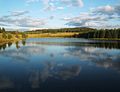
The Rolava (‹See Tfd›German: Rohlau) is a left tributary of the Ohře river in the northwest of the Czech Republic. It is 36.7 kilometres (22.8 mi) long...
2 KB (136 words) - 19:18, 6 March 2023
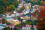
confluence of the Ohře (which flows across the city) with the Teplá and Rolava rivers. There are several small bodies of water in the northern half of...
37 KB (3,434 words) - 03:54, 10 September 2024

46.4 252.3 right Liboc 46.4 91.1 right Svatava / Zwota 41.0 203.0 left Rolava 36.7 177.4 left Libocký potok 30.3 219.4 left Bystřice 29.6 153.8 left Plesná...
10 KB (919 words) - 11:37, 28 September 2024

100 Vysoká Pec formerly Hochofen 640 m 23.375 Rolava 24.244 Rolava Novohamerský Tunnel (252 m) Rolava Weißbach Viaduct 26.202 Nové Hamry formerly Neuhammer...
5 KB (187 words) - 23:02, 31 August 2024

Bystřice (in Vojkovice) Teplá (in Karlovy Vary) Lomnický potok (in Březová) Rolava (in Karlovy Vary) Svatava (in Sokolov) Libava (in Kynšperk nad Ohří) Libocký...
25 KB (2,156 words) - 10:47, 30 September 2024

highest point is the Borový hill at 512 m (1,680 ft) above sea level. The Rolava River flows through the town. On the western edge of the town is the Novorolský...
6 KB (426 words) - 07:26, 2 September 2024

Municipality. Ālande Āres Cimdenieki Dubeņi Gūžas Iļģi Keramika Robežnieki Rolava Tilti Vītiņi {{ v t e "Reģionu, novadu, pilsētu un pagastu kopējā un sauszemes...
916 bytes (127 words) - 20:57, 23 September 2024
located on the Saxon side of the border. From west to east: Svatava (Zwota) Rolava (Rohlau) Zwickauer Mulde Schwarzwasser Chemnitz Würschnitz Zwönitz Freiberger...
65 KB (7,105 words) - 23:05, 31 August 2024

Sedlečko, p. of Šemnice Saubernitz: Zubrnice Saubsdorf: Supíkovice Sauersack: Rolava, now Přebuz* Sawerschitz: Zavržice, p. of Příbram Sawersdorf: Závišice Sazau...
261 KB (29,422 words) - 03:19, 14 July 2024

across the entire territory and drains it. Smaller rivers, such as Svatava, Rolava and Bystřice, flow into it from the mountain ranges along the territory...
4 KB (390 words) - 19:00, 22 August 2024
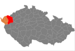
northeast. Its longest tributaries within the district are the rivers Teplá and Rolava. The southern part of the district is drained by the Střela. The district...
12 KB (852 words) - 07:30, 25 September 2024

point is the mountain Čertova hora at 987 m (3,238 ft) above sea level. The Rolava River originates in the municipal territory. The foundation of Přebuz is...
6 KB (390 words) - 12:57, 26 August 2024
drained to the northwest by the Große Pyra and to the southwest by the Rolava. To the east is the Kleiner Kranichsee, where the heart of the bog, unlike...
4 KB (283 words) - 11:15, 20 January 2024

is the mountain Tisovský vrch at 977 m (3,205 ft) above sea level. The Rolava river flows through the town. Nejdek was founded around 1250 as a tin mining...
8 KB (584 words) - 07:25, 2 September 2024