
Route 169 is a 47.36-mile-long (76.22 km) state highway in the U.S. states of Connecticut and Massachusetts. It begins in the city of Norwich, Connecticut...
14 KB (967 words) - 15:44, 23 December 2023

Route 131 is a 13.55-mile-long (21.81 km) state highway in the U.S. states of Massachusetts and Connecticut. It serves the southwestern portion of the...
8 KB (587 words) - 04:15, 23 June 2024

states of Connecticut and Massachusetts; it is maintained by the Connecticut Department of Transportation (CTDOT) and the Massachusetts Department of...
21 KB (1,342 words) - 15:27, 26 June 2024

Route 197 is a 14.17-mile-long (22.80 km) state highway in northeastern Connecticut and southern Massachusetts, running from Union, Connecticut, to Dudley...
7 KB (477 words) - 17:05, 27 September 2023
In the U.S. state of Connecticut, state highways are grouped into signed routes, unsigned special service roads (SSR), and unsigned state roads (SR). State...
35 KB (123 words) - 20:34, 25 January 2023

State Route 55 (NY 55) in Kerhonkson, New York, a hamlet in the Hudson Valley region. The eastern terminus is at Route 3A in Plymouth, Massachusetts. KML...
56 KB (4,047 words) - 02:50, 8 July 2024

Route 168 is a 9.17-mile-long (14.76 km) state route in the U.S. states of Massachusetts and Connecticut. The route connects the village of Congamond...
5 KB (357 words) - 22:22, 1 April 2023
U.S. Route 169 Alabama State Route 169 Arizona State Route 169 Arkansas Highway 169 California State Route 169 Connecticut State Route 169 Florida State...
3 KB (186 words) - 23:30, 4 April 2024

main route of the United States Numbered Highway System. While it currently runs east-northeast from Bishop, California, to Provincetown, Massachusetts, the...
61 KB (6,447 words) - 17:50, 10 July 2024

New England road marking system (redirect from Route 116 (Connecticut 1920s))
by Connecticut Route 9, U.S. Route 44, Connecticut Route 189, Connecticut Route 10, Massachusetts Route 10, New Hampshire Route 10, and U.S. Route 302...
158 KB (6,445 words) - 17:10, 1 February 2024

Canada–United States border near Third Connecticut Lake, where it connects to Quebec Route 257. Massachusetts Route 3 connects to the southern terminus of...
55 KB (3,184 words) - 21:33, 14 July 2024

Puritans from Massachusetts Bay Colony led by Thomas Hooker, who established the Connecticut Colony at Hartford. The Fundamental Orders of Connecticut were adopted...
193 KB (16,983 words) - 23:22, 14 July 2024
extension in the early 1980s, Route 52 was to be re-designated as an Interstate. Initially, Connecticut and Massachusetts requested that the American Association...
55 KB (4,675 words) - 22:36, 28 June 2024

Route 101 is a state highway in northeastern Connecticut running from Pomfret to the Rhode Island state line in Killingly. The road originated as a 19th-century...
7 KB (663 words) - 08:45, 25 February 2023

Route 9 is a 135.310-mile-long (217.760 km) major east–west state highway in Massachusetts, United States. Along with U.S. Route 20 (US 20), Route 2, and...
23 KB (1,128 words) - 02:18, 27 June 2024

U.S. Route 20 (US 20) runs its easternmost 153 miles (246 km) in the U.S. state of Massachusetts. The highway crosses the state border from New Lebanon...
29 KB (1,902 words) - 04:22, 12 July 2024

Route 171 is a state highway in northeastern Connecticut, running from Union to Putnam. Route 171 begins at an interchange from I-84 in northern Union...
6 KB (439 words) - 08:42, 25 February 2023

Boston Post Road (category U.S. Route 1)
Boston Post Road was a system of mail-delivery routes between New York City and Boston, Massachusetts, that evolved into one of the first major highways...
33 KB (3,745 words) - 21:24, 12 December 2023
Quiet Corner (redirect from Quiet Corner (Connecticut))
"Northeastern Connecticut Council of Governments". NECCOG. Retrieved August 25, 2023. Connecticut East Convention and Visitors Bureau Connecticut Route 169 on American...
11 KB (1,070 words) - 16:49, 11 June 2024

Route 32 is a 54.88-mile (88.32 km) primary north–south state highway in the U.S. state of Connecticut, beginning in New London and continuing via Willimantic...
8 KB (365 words) - 21:05, 4 June 2024

Route 244 is a secondary state highway in rural Northeastern Connecticut. It connects the towns of Eastford (at Route 198) and Pomfret (at Route 97). Route...
3 KB (278 words) - 02:35, 2 March 2023
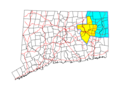
Route 6 at the Rhode Island state line. Other north–south routes include Route 12, which parallels I-395 through many local communities, Route 169, a...
27 KB (2,221 words) - 16:50, 11 June 2024

Interstate Route 12 (also known as the "Keene Way"). Present-day Vermont Route 12, New Hampshire Route 12, Massachusetts Route 12 and Connecticut Route 12 still...
18 KB (1,312 words) - 08:15, 16 April 2024
route through downtown Springfield—Boston Road and State Street—crossing the Connecticut River via the older Memorial Bridge (now Massachusetts Route...
44 KB (4,417 words) - 02:37, 16 July 2024

Massachusetts, the highway division of the Massachusetts Department of Transportation (MassDOT) assigns and marks a system of state-numbered routes....
70 KB (169 words) - 06:35, 12 March 2024

the Connecticut Colony. The settlement defected from Connecticut after four years, however, later joining forces with the coastal Massachusetts Bay Colony...
134 KB (13,683 words) - 22:16, 2 March 2024
modern Route 85, Route 2, Route 189, Route 20 Route 10: north-south from New London to Thompson, roughly modern Route 32, Route 169, Route 12, Route 193...
84 KB (1,553 words) - 04:13, 1 January 2024

and the seat of Hampden County, Massachusetts, United States. Springfield sits on the eastern bank of the Connecticut River near its confluence with three...
192 KB (17,520 words) - 17:57, 11 July 2024

Connecticut Route 10. Its number is derived from its original 1922 designation as New England Interstate Route 10. NH 10 begins at the Massachusetts state...
18 KB (1,257 words) - 02:38, 25 March 2023

writing of the Fundamental Orders of Connecticut, which provided a framework for Connecticut's separation for Massachusetts Bay Colony and the formation of...
186 KB (15,300 words) - 11:44, 6 July 2024