Rumsey is a hamlet in southern Alberta, Canada within Starland County. It is located 8 kilometres (5.0 mi) west of Highway 56, approximately 80 kilometres...
3 KB (98 words) - 21:10, 12 February 2024
Rumsey may refer to: Rumsey, Alberta Rumsey, California Rumsey, Kentucky Rumsey (surname) This disambiguation page lists articles associated with the...
167 bytes (43 words) - 23:58, 29 December 2019

been paved. All of Alberta's provincial highways are maintained by Alberta Transportation (AT), a department of the Government of Alberta. The network includes...
257 KB (2,635 words) - 05:43, 2 July 2024

Saskatchewan (1906), also known as Yid'n Bridge (Jews' Bridge) Trochu, Alberta (1906) Rumsey, Alberta (1906) Pine Ridge, Manitoba (1907) Birds Hill, Manitoba (1911)...
38 KB (2,975 words) - 07:55, 24 February 2024

"Highway 93 in Alberta" (Map). Google Maps. Google. Retrieved October 23, 2017. "Shell British Columbia-Alberta Highway Map". David Rumsey Map Collection...
18 KB (1,011 words) - 08:07, 20 April 2024

The province of Alberta, Canada, is divided into ten types of local governments – urban municipalities (including cities, towns, villages and summer villages)...
26 KB (8,110 words) - 16:26, 26 January 2024

Starland County (redirect from Dinosaur, Alberta)
Starland County is a municipal district located in southern Alberta, Canada. The municipality was incorporated in 1912, and established in the current...
10 KB (349 words) - 03:57, 2 May 2022
Our Roots: Canada's Local Histories Online - Pioneer Days : Scollard, Rumsey, Rowley 49°11′06″N 113°09′55″W / 49.18500°N 113.16528°W / 49.18500; -113...
2 KB (123 words) - 03:41, 10 September 2023

hamlet within Banff National Park in Alberta, Canada. Named after Princess Louise, Duchess of Argyll, it lies in Alberta's Rockies on the Bow River, 3 km (1...
12 KB (837 words) - 19:46, 27 June 2024

Hamlets in the Canadian province of Alberta are unincorporated communities administered by, and within the boundaries of, specialized municipalities or...
107 KB (2,593 words) - 19:51, 18 June 2024
List of postal codes of Canada: T (category Communications in Alberta)
Postal codes beginning with T are located within the Canadian province of Alberta. Only the first three characters are listed, corresponding to the Forward...
54 KB (208 words) - 17:16, 15 May 2024
Dead Man's Flats (redirect from Pigeon Mountain, Alberta)
designated place under the name of Pigeon Mountain. It is located within Alberta's Rockies at Highway 1 exit 98, approximately 7 kilometres (4.3 mi) southeast...
11 KB (872 words) - 20:30, 22 April 2024
clubs in Alberta are organized by the provincial governing body, Curling Alberta. Curling Alberta was formed in 2018 as an amalgamate of the Alberta Curling...
12 KB (910 words) - 18:45, 7 December 2023

Waterton Park (redirect from Waterton, Alberta)
Waterton Park, commonly referred to as Waterton, is a hamlet in southwestern Alberta, Canada within Improvement District No. 4 Waterton (Waterton Lakes National...
9 KB (395 words) - 03:47, 10 November 2023

ˈbɪʃ/ LAK lə BISH) is a hamlet in Lac La Biche County within northeast Alberta, Canada. It is located approximately 220 km (140 mi) northeast of the provincial...
39 KB (2,234 words) - 19:39, 8 May 2024

Fort McKay (redirect from Fort Mackay, Alberta)
Fort McKay (/məˈkaɪ/ mə-KY) or Fort MacKay is a community in northeast Alberta, Canada, located at the confluence of the Athabasca and MacKay rivers....
15 KB (902 words) - 22:22, 5 March 2024
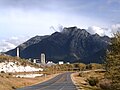
Exshaw (redirect from Exshaw, alberta)
Exshaw is a hamlet in Alberta, Canada within Municipal District (MD) of Bighorn No. 8. Located approximately 90 kilometres (56 mi) west of downtown Calgary...
18 KB (1,575 words) - 18:22, 9 June 2024

Fort Chipewyan (redirect from Chipewyan Settlement, Alberta)
ˈtʃɪpəwən/, commonly referred to as Fort Chip, is a hamlet in northern Alberta, Canada, within the Regional Municipality (RM) of Wood Buffalo. It is located...
25 KB (2,084 words) - 12:36, 10 December 2023
WAH-bə-skah), also known as Wabasca-Desmarais, is a hamlet in northern Alberta, Canada within the Municipal District (MD) of Opportunity No. 17. It is...
35 KB (2,457 words) - 17:34, 1 April 2024

an urban municipality status type used in the Canadian province of Alberta. Alberta villages are created when communities with populations of at least...
52 KB (1,892 words) - 20:29, 1 July 2023

Grande Cache (redirect from Grande Cache Lake Settlement, Alberta)
Grande Cache is a hamlet in West-Central Alberta, Canada within and administered by the Municipal District of Greenview No. 16. It is located on Highway...
17 KB (1,153 words) - 16:43, 17 June 2024

Nordegg (redirect from Brazeau, Alberta)
Nordegg is a hamlet in west-central Alberta, Canada within Clearwater County. It is in the North Saskatchewan River valley in the foothills of the Canadian...
19 KB (1,253 words) - 04:09, 10 September 2023

Lyalta Michichi Mossleigh Namaka Nightingale Queenstown Rosebud Rowley Rumsey Shouldice Sunnyslope Swalwell Torrington Travers Wimborne In the 2021 Census...
6 KB (317 words) - 15:02, 27 January 2024
Chasia Shumiatcher. Her father and brother homesteaded briefly in Rumsey, Alberta, before the rest of the family joined them in Calgary in August 1911...
8 KB (715 words) - 03:22, 16 September 2023

Maskwacis (redirect from Hobbema, Alberta)
from Hobbema (/hoʊˈbiːmə/), is an unincorporated community in central Alberta, Canada at intersection of Highway 2A and Highway 611, approximately 70...
17 KB (1,205 words) - 03:31, 10 September 2023

Alberta Provincial Highway No. 21, commonly referred to as Highway 21, is a north–south highway in Alberta, Canada that parallels Highway 2 between Calgary...
20 KB (1,356 words) - 21:48, 14 January 2024
Fort Vermilion (redirect from Fort Vermilion Settlement, Alberta)
northern Alberta, Canada, within Mackenzie County. Established in 1788, Fort Vermilion shares the title of oldest European settlement in Alberta with Fort...
29 KB (2,606 words) - 04:28, 28 May 2024

Lac des Arcs is a hamlet in Alberta, Canada within the Municipal District (MD) of Bighorn No. 8. It is located on the south side of the Bow River opposite...
7 KB (341 words) - 01:48, 7 May 2024
Thorhild is a hamlet in Alberta, Canada within Thorhild County. It is located at the intersection of Highway 18 and Highway 827, approximately 86 kilometres...
7 KB (421 words) - 08:30, 23 June 2024
La Crete (redirect from La Crête, Alberta)
(/ləˈkriːt/ lə-KREET), also spelled La Crête, is a hamlet in northern Alberta, Canada, within Mackenzie County. It is located on Highway 697, approximately...
15 KB (982 words) - 19:32, 18 May 2024