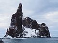
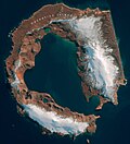
Sabrina Island is the largest of three small islets lying 1.5 km (0.93 mi) south of Buckle Island in the Balleny Islands of Antarctica and are part of...
3 KB (205 words) - 06:12, 12 November 2023
Sabrina Coast, a part of the coast of Antarctica Sabrina Ridge, Antarctica Sabrina Island, off Antarctica Sabrina Island (Azores), a temporary island...
2 KB (329 words) - 16:54, 3 August 2024

Island: Row Island, Borradaile Island (with Swan Base shelter hut) south of Buckle Island: Scott Cone, Chinstrap Islet, Sabrina Islet (with Sabrina Refuge...
10 KB (870 words) - 02:57, 11 July 2024
of small islets located off the southern tip of Sabrina Island within the Ross Dependency of Antarctica. The smaller of the two islets rises at a steep...
1 KB (63 words) - 16:30, 3 December 2023
Antarctic and sub-Antarctic islands. Antarctic islands are, in the strict sense, the islands around mainland Antarctica, situated on the Antarctic Plate...
74 KB (12,543 words) - 10:20, 25 June 2024

The geography of Antarctica is dominated by its south polar location and, thus, by ice. The Antarctic continent, located in the Earth's southern hemisphere...
23 KB (2,673 words) - 15:44, 4 June 2024
Deception Island (Antarctica) – via researchgate.net. "Deception Island". Global Volcanism Program. Smithsonian Institution. Portals: Geography Islands Engineering...
39 KB (4,065 words) - 11:57, 20 July 2024

Cape Evans (redirect from Inaccessible Island (Antarctica))
633; 166.400 (Cape Evans)) is a rocky cape on the west side of Ross Island, Antarctica, forming the north side of the entrance to Erebus Bay. The cape was...
7 KB (1,027 words) - 15:39, 14 February 2024

Drake Passage (category Straits of Antarctica)
South America's Cape Horn, Chile, Argentina, and the South Shetland Islands of Antarctica. It connects the southwestern part of the Atlantic Ocean (Scotia...
24 KB (2,628 words) - 18:29, 30 July 2024
Young Island, the largest of which is Borradaile Island. Several small islets lie off the island's southern extremity, Cape McNab, including Sabrina Islet...
3 KB (250 words) - 21:16, 22 May 2024

in Antarctica, including: the Balleny Islands Buckle Island Sabrina Island Sturge Island Young Island Scott Island Roosevelt Island Coulman Island the...
30 KB (1,787 words) - 02:30, 21 June 2024
Charlton Island is the westernmost of the Frazier Islands, lying in Vincennes Bay off Wilkes Land in East Antarctica. The island was mapped from air photographs...
2 KB (150 words) - 22:35, 11 July 2024
This article incorporates public domain material from "Lamarck Island (Antarctica)". Geographic Names Information System. United States Geological Survey...
3 KB (264 words) - 06:39, 26 December 2022

birth on Antarctica on January 7. Margaret Winslow of the United States is the first woman to lead an expedition to Livingston Island, Antarctica 1979 First...
39 KB (3,758 words) - 15:26, 26 July 2024

Cape Royds (redirect from Blue Lake (Antarctica))
dark rock cape forming the western extremity of Ross Island, facing on McMurdo Sound, Antarctica. It was discovered by the British National Antarctic...
12 KB (1,875 words) - 13:08, 29 March 2024

Wilkes Land (category East Antarctica)
Wilkes Land is a large district of land in eastern Antarctica, formally claimed by Australia as part of the Australian Antarctic Territory, though the...
5 KB (438 words) - 23:25, 10 June 2023
Fruitcake Bluff, Thompson Spur, Daniels Range, Victoria Land, Antarctica; an outcrop Fruit Cake Island, a fictional location from the 1896 fantasy novel The Magical...
3 KB (430 words) - 21:39, 3 March 2024

Coronation Island is the largest of the South Orkney Islands, 25 nautical miles (46 km) long and from 3 to 8 nautical miles (5.6 to 14.8 km) wide. The island extends...
5 KB (532 words) - 18:15, 4 June 2023

Hut Point Peninsula (redirect from Crater Hill (Antarctica))
long, projecting south-west from the slopes of Mount Erebus on Ross Island, Antarctica. McMurdo Station (US) and Scott Base (NZ) are Antarctic research stations...
16 KB (2,687 words) - 05:54, 8 July 2024
features a list of islands sorted by their name beginning with the letter S. A B C D E F G H I J K L M N O P Q R S T U V W X Y Z List of islands (by country)...
39 KB (63 words) - 04:59, 21 July 2024

Māori people (category Articles containing Cook Islands Māori-language text)
Government. Retrieved 22 August 2023. Imbler, Sabrina (2 July 2021). "The Maori Vision of Antarctica's Future". The New York Times. ISSN 0362-4331. Retrieved...
120 KB (12,366 words) - 17:13, 4 August 2024
John Balleny (category British explorers of Antarctica)
towards Antarctica in the early 1830s, and had decided to send a third - the 156–ton (bm), schooner Eliza Scott and the 54-ton cutter HMS Sabrina (18216)...
6 KB (686 words) - 16:12, 30 March 2024
barrio Paris Basin, a geological region of France Paris Peak, Anvers Island, Antarctica 3317 Paris, a minor planet named after the legendary figure of the...
8 KB (1,044 words) - 06:41, 29 June 2024
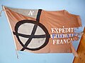
French Antarctic Expedition (category 1904 in Antarctica)
On their return trip from Antarctica, a party was briefly landed on 3 March 1949 on Sabrina Island, one of the Balleny Islands. The expedition also visited...
10 KB (1,351 words) - 09:59, 9 August 2024

Charcot. Cape Mascart forms the northernmost extremity of Adelaide Island, Antarctica, and is by the IHO regarded as the northernmost and easternmost border...
11 KB (1,362 words) - 21:23, 29 April 2024
120.750) is a small bay at the eastern end of the Sabrina Coast, Antarctica, with the Henry Islands lying in its western part. The bay was delineated...
1 KB (152 words) - 17:53, 20 January 2020

Cape Crozier (redirect from Wood Point (Antarctica))
169.400°E / -77.517; 169.400) is the most easterly point of Ross Island in Antarctica. It was discovered in 1841 during James Clark Ross's polar expedition...
13 KB (1,571 words) - 04:48, 29 May 2024

Antarctic toothfish (category Fish of Antarctica)
McMurdo Sound, Antarctica". Copeia. 1982 (2): 385–393. doi:10.2307/1444619. ISSN 0045-8511. JSTOR 1444619. Near, Thomas J.; Russo, Sabrina E.; Jones, Christopher...
39 KB (4,843 words) - 11:57, 9 August 2024

28E2274C. doi:10.1016/j.cub.2018.05.066. PMID 29983312. S2CID 51600014. Shawn Sabrina Murray (January 2004). "Searching for the Origins of African Rice Domestication"...
206 KB (21,218 words) - 20:39, 12 August 2024
Antarctic Specially Protected Area (category Antarctica agreements)
Specially Protected Area (ASPA) is an area on the continent of Antarctica, or on nearby islands, which is protected by scientists and several different international...
82 KB (191 words) - 18:25, 7 August 2024