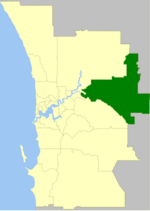
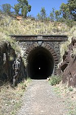
The Shire of Mundaring is a local government area in eastern metropolitan Perth, the capital of Western Australia. The Shire covers an area of 645 square...
13 KB (894 words) - 07:36, 28 February 2024
Newspaper Group) – weekly Mundaring magazine – monthly The only railway line current in the Mundaring Shire – is the third route of the Eastern Railway which...
9 KB (994 words) - 02:31, 17 October 2024
Greenmount, Western Australia (category Suburbs and localities in the Shire of Mundaring)
is a locality and a geographical feature in the Shire of Mundaring, Western Australia, on the edge of the Darling Scarp. It is a vital point in the transport...
11 KB (1,257 words) - 16:09, 24 August 2024
Mount Helena, Western Australia (category Suburbs and localities in the Shire of Mundaring)
government in the Shire of Mundaring. Mundaring: Mundaring Shire. ISBN 0-9592776-3-3. Mount Helena on Geoscience Australia Mundaring and Hills Historical...
6 KB (599 words) - 04:02, 31 March 2024
construction of the dam in the late 1890s. This involved the building of a Mundaring Weir railway line from Mundaring to the Mundaring Weir site. The...
12 KB (1,296 words) - 12:26, 3 November 2024
Bellevue, Western Australia (category Suburbs and localities in the Shire of Mundaring)
community and local government in the Shire of Mundaring. Mundaring: Mundaring Shire. ISBN 0-9592776-3-3. Mundaring and Hills Historical Society website...
9 KB (954 words) - 02:30, 17 October 2024
Perth metropolitan region (category Regions of Western Australia)
City of Wanneroo and the City of Swan to the north, the Shire of Mundaring, City of Kalamunda, and the City of Armadale to the east, the Shire of Serpentine-Jarrahdale...
9 KB (794 words) - 21:39, 15 March 2024
Mundaring Cemetery is located at the intersection of Yarri Grove and Railway Terrace, Mundaring, Western Australia. Mundaring Cemetery was gazetted as...
4 KB (236 words) - 05:05, 27 January 2023
of the Darling Scarp and hinterland east of the scarp that lies within the Shire of Mundaring, City of Swan, and the City of Kalamunda and as part of...
7 KB (724 words) - 14:09, 26 August 2023
Lake Leschenaultia (category State Register of Heritage Places in the Shire of Mundaring)
Retrieved 12 January 2020. Elliot, Ian (1983). Mundaring - A History of the Shire (2nd ed.). Mundaring: Mundaring Shire. ISBN 0-9592776-0-9. Spillman, Ken (2003)...
5 KB (374 words) - 15:10, 23 July 2024
the Shire of Kalamunda, the remainder of the Shire of Mundaring and further territory in the City of Swan from the Division of Pearce. As a result of adding...
15 KB (697 words) - 17:35, 28 April 2024
Stoneville, Western Australia (category Suburbs and localities in the Shire of Mundaring)
government in the Shire of Mundaring. Mundaring: Mundaring Shire. ISBN 0-9592776-3-3. Stoneville on Geoscience Australia Mundaring and Hills Historical...
4 KB (390 words) - 04:33, 31 March 2024
City of Armadale to the division of Canning, and most of the Shire of Kalamunda, a small part of the Shire of Mundaring and a small part of the City of Swan...
27 KB (2,340 words) - 22:49, 1 June 2024
Perth (redirect from Geography of Perth)
City of Wanneroo and the City of Swan to the north, the Shire of Mundaring, City of Kalamunda and the City of Armadale to the east, the Shire of Serpentine-Jarrahdale...
153 KB (13,536 words) - 15:52, 10 November 2024
Wooroloo, Western Australia (category Suburbs and localities in the Shire of Mundaring)
the outer fringe of the Perth metropolitan region, located off Great Eastern Highway in the eastern part of the Shire of Mundaring. At the 2021 census...
6 KB (604 words) - 07:44, 10 April 2024
was elected unopposed by the board on 12 May 1938 for the following term. Elliot, Ian (1983). Mundaring – A History of the Shire. Shire of Mundaring....
3 KB (121 words) - 15:02, 18 December 2023
Darlington, Western Australia (category Suburbs and localities in the Shire of Mundaring)
locality in the Shire of Mundaring on the Darling Scarp, bisected by Nyaania Creek and north of the Helena River. About one kilometre to the west of Darlington...
12 KB (1,318 words) - 02:33, 17 October 2024
Sawyers Valley, Western Australia (category Suburbs and localities in the Shire of Mundaring)
government in the Shire of Mundaring. Mundaring: Mundaring Shire. ISBN 0-9592776-3-3. Sawyer's Valley on Geoscience Australia Mundaring and Hills Historical...
4 KB (306 words) - 06:16, 1 May 2023
Helena Valley, Western Australia (category Suburbs and localities in the Shire of Mundaring)
4 February 2024]. Elliot, Ian (1983). Mundaring - A History of the Shire (2nd ed.). Mundaring: Mundaring Shire. ISBN 0-9592776-0-9. Spillman, Ken (2003)...
4 KB (327 words) - 13:11, 29 March 2024
Chidlow, Western Australia (category Suburbs and localities in the Shire of Mundaring)
government in the Shire of Mundaring. Mundaring: Mundaring Shire. ISBN 0-9592776-3-3. Watson, Lindsay (1995). The railway history of Midland Junction :...
6 KB (585 words) - 03:52, 20 March 2024
Glen Forrest, Western Australia (category Suburbs and localities in the Shire of Mundaring)
government in the Shire of Mundaring. Mundaring: Mundaring Shire. ISBN 0-9592776-3-3. Glen Forrest on Geoscience Australia Mundaring and Hills Historical...
6 KB (546 words) - 02:20, 29 March 2024
Goldfields Water Supply Scheme (redirect from River of Steel)
railway line at Mundaring closed in 1954. The sudden Darling Range height rise between Mundaring and Northam required the location of Pumping Station...
25 KB (2,705 words) - 02:01, 17 October 2024
Swan View, Western Australia (category Suburbs and localities in the Shire of Mundaring)
local government in the Shire of Mundaring. Mundaring: Mundaring Shire. ISBN 0-9592776-3-3. Swan View Community Association Mundaring and Hills Historical...
7 KB (682 words) - 01:16, 22 August 2024
Parkerville, Western Australia (category Suburbs and localities in the Shire of Mundaring)
Parkerville is a suburb in the Shire of Mundaring in Perth Western Australia. Jane Brook flows through Parkerville on its way down to the Swan River through...
5 KB (523 words) - 11:20, 30 April 2024
The Mundaring and Hills Historical Society (MHHS) is a local history society for the Shire of Mundaring, based in Mundaring, Western Australia. Affiliated...
5 KB (522 words) - 02:27, 17 October 2024
The Lakes, Western Australia (category Suburbs and localities in the Shire of Mundaring)
retrieved 13 November 2016 Elliot, Ian (1983). Mundaring - A History of the Shire (2nd ed.). Mundaring: Mundaring Shire. ISBN 0-9592776-0-9. Spillman, Ken (2003)...
5 KB (368 words) - 18:09, 23 March 2023
state of Australia, with an area of 2,527,013 square kilometres (975,685 sq mi), and its fourth most populous, with a population of 2,660,026 as of the...
25 KB (543 words) - 05:42, 30 December 2022
unique in the Shire of Mundaring. Sitting opposite the Railway Reserve Heritage Trail, the site also has historic significance as the location of Lot Leather's...
12 KB (1,133 words) - 15:14, 2 June 2022
Mahogany Creek, Western Australia (category Suburbs and localities in the Shire of Mundaring)
from 12 June 2023]. Elliot, Ian (1983). Mundaring - A History of the Shire (2nd ed.). Mundaring: Mundaring Shire. ISBN 0-9592776-0-9. Spillman, Ken (2003)...
5 KB (406 words) - 06:58, 20 March 2024
John Forrest National Park (category State Register of Heritage Places in the Shire of Mundaring)
ISBN 978-0-646-24461-7 Elliot, Ian; Elliot, Ian (1983), Mundaring : a history of the shire, Shire of Mundaring, ISBN 978-0-9592776-0-9 - has a specific chapter...
10 KB (1,053 words) - 02:28, 12 July 2024


