The Shuttle Radar Topography Mission (SRTM) is an international research effort that obtained digital elevation models on a near-global scale from 56°S...
21 KB (2,107 words) - 07:49, 3 May 2024
STS-99 (category Space Shuttle missions)
Center, Florida. The primary objective of the mission was the Shuttle Radar Topography Mission (SRTM) project. This was also the last solo flight of Endeavour;...
18 KB (1,155 words) - 19:32, 16 October 2024
(75 mi) wide swath. The new radar system is smaller than, but similar to, the one that flew on NASA's Shuttle Radar Topography Mission (SRTM), which made high-resolution...
16 KB (1,696 words) - 20:07, 5 November 2024
separate shuttle missions. Once from the Space Shuttle Endeavour in April 1994 on (STS-59) and again in October 1994 on (STS-68). The radar was run by...
6 KB (538 words) - 23:08, 25 April 2024
500 m. All elevations have been checked or chosen to match the Shuttle Radar Topography Mission-based contour lines in the Google terrain maps. The highest...
28 KB (537 words) - 00:40, 25 June 2024
NISAR (satellite) (redirect from NASA-ISRO Synthetic Aperture Radar mission)
satellite Indian Remote Sensing List of Indian satellites Seasat Shuttle Radar Topography Mission "Satellite: NISAR". World Meteorological Organization (WMO)...
14 KB (1,181 words) - 04:37, 8 November 2024
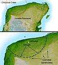
Shaded Relief with Height as Color, Yucatan Peninsula, Mexico". Shuttle Radar Topography Mission. NASA. Archived from the original on March 13, 2017. Retrieved...
84 KB (8,238 words) - 20:07, 26 October 2024
for the Space Shuttle Launch on Need (LON) missions to be launched on short notice for STS-114 and STS-121, in the event that the shuttle became disabled...
127 KB (4,414 words) - 16:15, 29 October 2024
Shaded Relief with Height as Color, Yucatan Peninsula, Mexico". Shuttle Radar Topography Mission. NASA. Retrieved October 28, 2010. Renne, P. R.; Deino, A....
28 KB (3,035 words) - 22:20, 9 October 2024
Remote-Sensing Satellite (ERS, 1991) using the same method, the Shuttle Radar Topography Mission (SRTM, 2000) using single-pass SAR and the Advanced Spaceborne...
30 KB (3,236 words) - 06:45, 14 October 2024
(scatterometer, United States, 1999-2008) Shuttle Imaging Radar on the Shuttle Radar Topography Mission (SAR, United States, 2000) Envisat (SAR, altimeter, European...
10 KB (1,333 words) - 18:13, 30 October 2024
fifth and final operational Shuttle built. It embarked on its first mission, STS-49, in May 1992 and its 25th and final mission, STS-134, in May 2011. STS-134...
61 KB (4,636 words) - 20:43, 21 October 2024
Earth uses digital elevation model data collected by NASA's Shuttle Radar Topography Mission. This creates the impression of three-dimensional terrain,...
94 KB (8,574 words) - 10:50, 7 November 2024
OpenStreetMap data for the road network and elevation data from the Shuttle Radar Topography Mission is used. The front-end is open-source too and called GraphHopper...
7 KB (631 words) - 05:43, 18 June 2024
One of the most important missions is the Shuttle Radar Topography Mission which was launched in February 2000 on the shuttle Endeavor. In 2003, van Zyl...
5 KB (499 words) - 01:47, 6 November 2024
Earth's surface with unprecedented accuracy using data from the Shuttle Radar Topography Mission. If the two samples are separated in time, perhaps from two...
78 KB (11,070 words) - 09:32, 2 November 2024
NASA STS-99 mission in February 2000 used a SAR antenna mounted on the Space Shuttle to gather data for the Shuttle Radar Topography Mission (SRTM). In...
39 KB (4,698 words) - 00:04, 6 November 2024
mountain is located in the Guinea Highlands range. Data from the Shuttle Radar Topography Mission revealed that the summit is higher in elevation than the previously...
3 KB (222 words) - 11:42, 9 November 2024
Jahre-radar.de: "100 Years of Radar"—(in German) Jahre-radar.de: "The Century of Radar – from Christian Hülsmeyer to Shuttle Radar Topography Mission"—(in...
151 KB (22,275 words) - 23:04, 2 November 2024
employs 25% of the population. Estimated based on DEM data from Shuttle Radar Topography Mission "ILO census data". Cornell University. 2002. Retrieved 2008-05-03...
6 KB (126 words) - 17:30, 7 August 2023
Satellite image PCD Foulepointe Estimated based on DEM data from Shuttle Radar Topography Mission La Gazette de la Grande Ile - 14 May 2013 Eaux et hydrographie...
6 KB (189 words) - 08:31, 7 May 2024
Wayback Machine, World Heritage Site, accessed on April 10, 2009. Elevation data supplied by the Shuttle Radar Topography Mission. Peakbagger listing v t e...
2 KB (94 words) - 14:24, 12 September 2024
(born 1953), ESA astronaut and geophysicist, who was on the Shuttle Radar Topography Mission in February 2000 Georg Thiele (1881–1914), Imperial German...
5 KB (655 words) - 10:47, 8 August 2024
STS-2 (category Space Shuttle missions)
helped adjust the Shuttle's orbit for use of the radar. During the mission, President Reagan called the crew of STS-2 from Mission Control Center in Houston...
21 KB (1,970 words) - 01:36, 4 November 2024
hypsometric tints instead of contour lines to indicate elevation. Shuttle Radar Topography Mission Advanced Spaceborne Thermal Emission and Reflection Radiometer...
6 KB (128 words) - 21:28, 14 September 2023
mineral resources in the area. Estimated based on DEM data from Shuttle Radar Topography Mission "ILO census data". Cornell University. 2002. Retrieved 2008-03-11...
5 KB (138 words) - 20:23, 22 October 2024
Jet Propulsion Laboratory (redirect from Outer Planets Mission Analysis Group)
Pioneer 3 and 4 Psyche: Journey to a Metal World Ranger program Shuttle Radar Topography Mission Soil Moisture Active Passive (SMAP) Spitzer Space Telescope...
66 KB (6,121 words) - 08:16, 8 November 2024
airborne and spacecraft radars have mapped the entire planet, for various purposes. One example is the Shuttle Radar Topography Mission, which mapped large...
14 KB (1,520 words) - 17:26, 4 September 2024
Mamoru Mohri (category Space Shuttle program astronauts)
Endeavour's flight deck during STS-99 Flight Day 4 of the Shuttle Radar Topography Mission (14 February 2000) STS-47 Endeavour, crew members with Mamoru...
5 KB (351 words) - 23:10, 27 October 2024
Gerhard Thiele (category Space Shuttle program astronauts)
STS-99 Shuttle Radar Topography Mission. During 2003 and 2004, he trained in Russia as the backup for André Kuipers on the Soyuz TMA-4 mission. He retired...
3 KB (294 words) - 03:25, 20 March 2024


