
The Tehachapi Loop is a 3,779-foot-long (0.72 mi; 1.15 km) spiral, or helix, on the Union Pacific Railroad Mojave Subdivision through Tehachapi Pass,...
12 KB (1,112 words) - 00:53, 16 August 2024

Desert. The southern boundary is at Tehachapi Pass. Physiographically, the Sierra is a section of the Cascade–Sierra Mountains province, which in turn is...
72 KB (7,401 words) - 04:36, 19 August 2024

the western tip of the Mojave Desert. It is situated between the Tehachapi, Sierra Pelona, and the San Gabriel Mountains. The valley was named for the...
41 KB (4,581 words) - 19:16, 7 July 2024

Walker Pass (category Mountain passes of the Sierra Nevada (United States))
along the Sierra Crest, with more southerly Tehachapi Pass traditionally marking the geographic divide between the Sierra Nevada and Tehachapi Mountains...
7 KB (615 words) - 23:42, 15 August 2024
California City Delano Maricopa McFarland Ridgecrest Shafter Taft Tehachapi Wasco Alta Sierra Bakersfield Country Club Bear Valley Springs Bodfish Boron Buttonwillow...
121 KB (6,561 words) - 21:57, 5 September 2024
Endurance (TV series) (redirect from Endurance: Tehachapi)
umbrella from 2002 to 2006. Three seasons of Endurance (Hawaii, Tehachapi and High Sierras) were each nominated for a Daytime Emmy Award in the category...
90 KB (5,781 words) - 13:30, 2 August 2024
Laguna, Santa Rosa, San Jacinto, San Bernardino, San Gabriel, Liebre, Tehachapi, Sierra Nevada, and Klamath ranges in California, and the Cascade Range in...
49 KB (4,776 words) - 19:41, 29 August 2024
the common definition of the Sierra Nevada as the mountain range extending from Fredonyer Pass in the north to Tehachapi Pass in the south. It is also...
53 KB (1,282 words) - 05:15, 10 November 2023

Tejon Pass (category Tehachapi Mountains)
known as Portezuelo de Cortes, Portezuela de Castac, and Fort Tejon Pass is a mountain pass between the southwest end of the Tehachapi Mountains and northeastern...
22 KB (2,391 words) - 06:37, 14 August 2024

Mexico Sierra de San Francisco, Central Baja California, Mexico Sierra de Guadalupe cave paintings, Central Baja California, Mexico Sierra de la Giganta...
17 KB (1,775 words) - 14:24, 15 June 2024
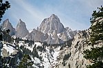
elevation of 14,505 feet (4,421 m). It is in East–Central California, in the Sierra Nevada, on the boundary between California's Inyo and Tulare counties, and...
31 KB (2,662 words) - 07:28, 1 August 2024

Geography of California (section Sierra Nevada)
970 km2), California is among the most geographically diverse states. The Sierra Nevada, the fertile farmlands of the Central Valley, and the arid Mojave...
31 KB (3,822 words) - 17:08, 20 August 2024
Incline Village, Nevada (redirect from Sierra Nevada Wood and Lumber)
the CDP Crystal Bay, Nevada was counted jointly with Incline Village. Sierra Nevada University's main campus is located in Incline Village. It has some...
18 KB (1,557 words) - 21:04, 6 September 2024

and the Great Basin Desert.: 408 The Mojave Desert is bounded by the Tehachapi Mountains on the northwest, the San Gabriel and San Bernardino Mountains...
17 KB (1,708 words) - 17:40, 8 August 2024
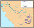
Kern River (category Rivers of the Sierra Nevada (United States))
approximately 165 miles (270 km) long. It drains an area of the southern Sierra Nevada mountains northeast of Bakersfield. Fed by snowmelt near Mount Whitney...
51 KB (5,747 words) - 02:10, 24 May 2024

Mountains, California Shandin Hills, California Sierra Pelona Ridge, California Simi Hills, California Tehachapi Mountains, California Topatopa Mountains, California...
51 KB (4,774 words) - 13:49, 4 August 2024

the north to the Tehachapi Mountains in the south, and from the California coastal ranges (Diablo and Temblor) in the west to the Sierra Nevada in the east...
66 KB (7,226 words) - 14:02, 21 August 2024

American River (redirect from Río de los Americanos)
River is a 30-mile-long (50 km) river in California that runs from the Sierra Nevada mountain range to its confluence with the Sacramento River in downtown...
40 KB (4,164 words) - 02:45, 4 September 2024

Program in two locations, the California City Correctional Facility and Tehachapi California Correctional Institution. The 420-acre (1.7 km2) Indian Wells...
8 KB (467 words) - 22:19, 30 June 2024

communities of Tehachapi and Arvin. The earthquake's destructive force bent cotton fields into U shapes, slid a shoulder of the Tehachapi Mountains across...
136 KB (12,121 words) - 21:13, 31 August 2024
Buttes Sherburne Hills Ship Mountains Sierra Azul Sierra de Salinas Sierra Madre Mountains Sierra Nevada Sierra Pelona Mountains Silurian Hills Simi Hills...
13 KB (1,166 words) - 22:52, 4 September 2024
1857 Fort Tejon earthquake (category Tehachapi Mountains)
junction of the San Andreas and Garlock Faults, where the Tehachapi, San Emigdio, and Sierra Pelona Transverse Ranges come together. The earthquake is...
25 KB (2,834 words) - 20:40, 21 June 2024

The Tehachapi Railroad Depot was a railroad station in Tehachapi, California. The Southern Pacific Railroad built the line through the area in 1876. The...
5 KB (324 words) - 21:52, 19 August 2024
Rancho La Liebre (category Tehachapi Mountains)
area. The rancho was mostly in the mountainous terrain of the Tehachapi Mountains and Sierra Pelona Mountains, in the northwest part of Los Angeles County...
4 KB (514 words) - 16:13, 5 April 2024

Gorman, California (category Tehachapi Mountains)
three Transverse System mountain ranges meet, namely the Sierra Pelona Mountains, the Tehachapi Mountains, and the San Emigdio Mountains. One of the Mountain...
28 KB (3,086 words) - 03:22, 15 August 2024

bounded by the Sierra Nevada in the east, the coastal mountain ranges in the west, the Cascade Range to the north and by the Tehachapi Mountains in the...
275 KB (23,796 words) - 00:57, 1 September 2024
Rosamond High School, Rosamond Taft Union High School, Taft Tehachapi High School, Tehachapi Wasco High School, Wasco Buena Vista High School (continuation)...
91 KB (6,684 words) - 01:14, 22 July 2024
Sierra National Forest is a U.S. national forest located on the western slope of the central Sierra Nevada in California, bounded on the northwest by...
17 KB (1,687 words) - 03:01, 31 March 2024

Feather River (category Rivers of the Sierra Nevada (United States))
Feather Rivers. These and other tributaries drain part of the northern Sierra Nevada, and the extreme southern Cascades, as well as a small portion of...
32 KB (3,938 words) - 05:26, 4 April 2024

List of mountain passes (section Tehachapi Mountains)
Pass Yuba Pass Aeroplane Pass Metsantan Pass Sifton Pass Oak Creek Pass Tehachapi Pass Tejon Pass Emory Pass – New Mexico, NM Highway 152 crosses this pass...
43 KB (3,236 words) - 20:26, 25 July 2024