
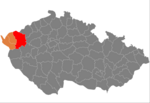
The Slavkov Forest (formerly also Emperor's Forest; Czech: Slavkovský les, German: Kaiserwald) is a highland and geomorphological mesoregion of the Czech...
10 KB (1,051 words) - 06:37, 17 July 2024
Slavkov may refer to: Slavkov (Opava District), a municipality and village in the Moravian-Silesian Region Slavkov (Uherské Hradiště District), a municipality...
1 KB (176 words) - 07:49, 5 September 2023

Slavkov u Brna (Czech pronunciation: [ˈslafkof ˈu br̩na]; German: Austerlitz) is a town in Vyškov District in the South Moravian Region of the Czech Republic...
12 KB (1,087 words) - 14:21, 7 June 2024

lies in a flat area of the Upper Palatine Forest Foothills, and the northern tip lies in the Slavkov Forest. The Teplá River originates in the woods in...
19 KB (1,846 words) - 11:58, 19 May 2024
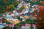
including the valley of the Teplá River, lies in a hilly landscape of the Slavkov Forest and in the eponymous protected landscape area. The highest point is...
36 KB (3,389 words) - 04:32, 22 July 2024

Franconian Heights, Franconian Switzerland, the Fichtel Mountains and the Slavkov Forest. The Castle Road has a length of over 1,000 kilometres (600 mi). The...
7 KB (522 words) - 16:53, 13 June 2024

sub-Mediterranean forest habitats. Broadleaf forests (Teutoburger Forest, Germany) Conifer in the montane parts Inside the conifer forests (Black Forest, Germany)...
15 KB (556 words) - 15:41, 3 August 2024

Horní Slavkov is located about 11 kilometres (7 mi) southeast of Sokolov and 11 km (7 mi) southwest of Karlovy Vary. It lies in the Slavkov Forest. The...
8 KB (617 words) - 05:32, 28 May 2024

10 m 26 ft 7 in × 20 ft 0 in 9 The Meeting at Křížky [cs] Utraquism Slavkov Forest, Czech Republic 1419 1916 4.05 m × 6.20 m 13 ft 3 in × 20 ft 4 in 10...
19 KB (1,324 words) - 00:19, 30 April 2024

harmonic landscape with a typical relief, with a considerable share of natural forest and permanent grassy ecosystems, there can also be preserved human settlement...
11 KB (660 words) - 20:34, 1 January 2024

Massif. It runs between two ranges: Ore Mountains in the north and Slavkov Forest in the south. It is no further subdivided into microregions. The highest...
4 KB (388 words) - 13:24, 2 March 2024

Battle of Austerlitz (redirect from Battle of Slavkov)
battle occurred near the town of Austerlitz in the Austrian Empire (now Slavkov u Brna in the Czech Republic). Around 158,000 troops were involved, of...
69 KB (7,821 words) - 04:25, 16 August 2024

Sokolov and 8 km (5 mi) southwest of Karlovy Vary. It lies mostly in the Slavkov Forest, only the northwestern part of the town extends into the Sokolov Basin...
9 KB (729 words) - 17:51, 28 May 2024

entire flow of the river is located in the protected landscape area of Slavkov Forest. The area of bogs where the Teplá originates is protected as Prameniště...
5 KB (465 words) - 08:24, 12 December 2023

Basin. The eastern part of the municipal territory extends into the Slavkov Forest and includes the highest point of Sokolov, the hill Zelený močál at...
11 KB (1,030 words) - 17:51, 17 May 2024

Mountains (west), Upper Palatine Forest (southwest), Upper Palatine Forest Foothills (south), Teplá Highlands (east), Slavkov Forest (northeast) and Ore Mountains...
11 KB (732 words) - 11:55, 15 August 2024

municipal territory lies in the Upper Palatine Forest Foothills, the northeastern part lies in the Slavkov Forest. The highest point is 928 metres (3,045 ft)...
10 KB (753 words) - 08:03, 18 July 2024
Ore Mountains (north), Doupov Mountains (east), Sokolov Basin (west), Slavkov Forest (west), Teplá Highlands (south) and Rakovník Uplands (small part in...
13 KB (858 words) - 11:55, 15 August 2024

flows through the Eger Graben and separates the Ore Mountains from the Slavkov Forest and the Doupov Mountains. The trench continues to the northeast along...
3 KB (308 words) - 16:33, 17 March 2023

located about 16 kilometres (10 mi) south of Karlovy Vary. It lies in the Slavkov Forest. The highest point is the Besídka hill at 713 m (2,339 ft) above sea...
7 KB (451 words) - 05:20, 22 May 2024

highest point of the whole Slavkov Forest, is located in the municipality. A large part of Dolní Žandov belongs to the Slavkov Forest Protected Landscape Area...
7 KB (544 words) - 07:21, 18 July 2024

geomorphological mesoregions: Ore Mountains (north), Sokolov Basin (centre), Slavkov Forest (south), Cheb Basin (small part in the west) and Fichtel Mountains (very...
10 KB (581 words) - 11:55, 15 August 2024

small part of the municipal territory in the east extends into the Slavkov Forest. The highest point is at 500 m (1,600 ft) above sea level. The Ohře...
8 KB (542 words) - 06:40, 28 May 2024

geomorphological subsystems. The Bohemian Massif within the sub-system of Hercynian Forest forms three quarters of the country. The southeastern and eastern part of...
17 KB (292 words) - 04:08, 24 July 2024

The southeastern part of the municipal territory extends into the Slavkov Forest and includes the highest point of Kynšperk nad Ohří at 580 m (1,900 ft)...
6 KB (362 words) - 06:46, 28 May 2024

proper lies in the Teplá Highlands. The northwestern part lies in the Slavkov Forest. The highest point is the hill U Odolenovických hranic at 739 m (2,425 ft)...
6 KB (337 words) - 06:37, 22 May 2024

Sokolov and 15 km (9 mi) southwest of Karlovy Vary. It lies in the Slavkov Forest. The highest point is the hill Špičák at 829 m (2,720 ft) above sea...
8 KB (694 words) - 06:42, 28 May 2024

town proper lies in the Teplá Highlands, the western part lies in the Slavkov Forest, and a small part in the northeast extends into the Doupov Mountains...
8 KB (630 words) - 05:27, 22 May 2024

about 7 kilometres (4 mi) southeast of Karlovy Vary. It lies in the Slavkov Forest. The highest point is the hill Andělská hora at 713 m (2,339 ft) above...
6 KB (397 words) - 05:17, 22 May 2024

fishponds. The western part of the municipal territory is situated in the Slavkov Forest Protected Landscape Area. The Teplá Abbey was founded in 1193 by nobleman...
8 KB (555 words) - 06:10, 24 June 2024