
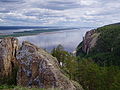
The Sokolov Basin or Falkenau Basin (Czech: Sokolovská pánev; German: Falkenauer Becken, formerly also Falkenau-Elbogen-Karlsbader Becken) is a structural...
4 KB (388 words) - 13:24, 2 March 2024

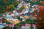
Front in World War II. Sokolov is located about 16 kilometres (10 mi) southwest of Karlovy Vary. It lies mostly in the Sokolov Basin. The eastern part of...
11 KB (1,030 words) - 17:51, 17 May 2024

geomorphological mesoregions: Ore Mountains (north), Sokolov Basin (centre), Slavkov Forest (south), Cheb Basin (small part in the west) and Fichtel Mountains...
10 KB (581 words) - 08:29, 19 June 2024

Loket (redirect from Loket (Sokolov District))
Slavkov Forest, only the northwestern part of the town extends into the Sokolov Basin. The highest point is the hill Zelenáč at 707 m (2,320 ft) above sea...
9 KB (729 words) - 17:51, 28 May 2024
most of the built-up area lies in a relatively flat landscape of the Sokolov Basin. The southern part, including the valley of the Teplá River, lies in...
37 KB (3,471 words) - 20:58, 16 June 2024
north east. Areas affected the most by heavy industry are the Sokolov Basin and the Most Basin in the north-west of the Czech Republic. The extensive deposits...
20 KB (954 words) - 20:26, 12 June 2024
by narrow fingers of the aforementioned basin. South(east) of the Western Ore Mountains lie the Sokolov Basin, the Eger Graben and the Doupov Mountains...
65 KB (7,096 words) - 10:13, 2 June 2024

northeast along the valley of the Bílina and later, as the North Bohemian Basin, separates the Ore Mountains from the Bohemian Central Mountains, where...
3 KB (308 words) - 16:33, 17 March 2023
geomorphological mesoregions: Ore Mountains (north), Doupov Mountains (east), Sokolov Basin (west), Slavkov Forest (west), Teplá Highlands (south) and Rakovník...
12 KB (858 words) - 08:29, 19 June 2024

kilometres (7 mi) west of Sokolov and 26 km (16 mi) southwest of Karlovy Vary. It lies on the border of the Cheb Basin and Sokolov Basin. The highest point is...
5 KB (285 words) - 06:12, 28 May 2024

kilometres (1 mi) northwest of Sokolov and 17 km (11 mi) west of Karlovy Vary. The municipal territory lies mostly in the Sokolov Basin, only the northern part...
6 KB (393 words) - 06:21, 28 May 2024

northeast of Karlovy Vary. Most of the municipal territory lies in the Sokolov Basin, but it also extends to the Doupov Mountains in the east and to the...
15 KB (1,405 words) - 05:22, 22 May 2024

9 kilometres (6 mi) northeast of Sokolov and 7 km (4 mi) west of Karlovy Vary. It lies mostly in the Sokolov Basin, only the northernmost part of the...
8 KB (619 words) - 13:24, 19 May 2024

of the municipal territory with half of the town proper lies in the Sokolov Basin. The highest point is near the top of the Lazský vrch hill at 847 m...
7 KB (486 words) - 05:17, 28 May 2024

the Sokolov Basin. Along the underflow of the Svatava, there is the market town of Svatava. After 41 km (25 mi), the Svatava joins the Ohře in Sokolov. Glasbach...
4 KB (343 words) - 15:35, 12 May 2024

6 kilometres (4 mi) northeast of Sokolov and 9 km (6 mi) west of Karlovy Vary. It lies mostly in the Sokolov Basin, only a small part of the municipal...
8 KB (542 words) - 06:40, 28 May 2024
Sergeyevich Sokolov (Russian: Борис Серге́евич Соколов; April 9, 1914 – September 2, 2013) was a Russian geologist and paleontologist. Sokolov authored reference...
7 KB (612 words) - 05:54, 20 June 2024

Pyotr Petrovich Sokolov (Russian: Пётр Петрович Соколов; 1821, Saint Petersburg - 2 October 1899, Saint Petersburg) was a Russian painter and illustrator...
3 KB (247 words) - 19:03, 17 March 2024

The remaining two provinces, Western Pannonian Plain within the Pannonian Basin and North European Plain within the European Plain, cover only a small part...
17 KB (292 words) - 03:12, 19 May 2024

north of Karlovy Vary. Most of the municipal territory lies in the Sokolov Basin, but it also extends to the Ore Mountains in the north. The highest...
7 KB (517 words) - 05:28, 22 May 2024
Lena (river) (category Lena basin)
Climate Models" (PDF). 2018. http://www.abratsev.narod.ru/biblio/sokolov/p1ch23b.html, Sokolov, Eastern Siberia // Hydrography of USSR. (in russian) "River...
19 KB (1,594 words) - 03:53, 11 June 2024

kilometres (4 mi) northwest of Karlovy Vary. The town proper lies in the Sokolov Basin, but the municipal territory also extends to the north into the Ore...
6 KB (430 words) - 07:07, 22 May 2024

about 2 kilometres (1 mi) northeast of Karlovy Vary. It lies in the Sokolov Basin. The highest point is the hill Ptačí vrch at 489 m (1,604 ft) above...
6 KB (361 words) - 05:17, 22 May 2024

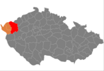
Habartov (category Populated places in Sokolov District)
of the Ore Mountains, the southern part of Habartov extends into the Sokolov Basin. The highest point is the hill Částkovský vrch at 598 metres (1,962 ft)...
6 KB (391 words) - 05:24, 28 May 2024
Blagoveshchensk. List of rivers of Russia "Amur-Heilong River Basin Reader" (PDF). ISBN 9789881722713. Sokolov, Far East // Hydrography of USSR. (in Russian) "Река...
5 KB (280 words) - 14:43, 28 March 2024

Vintířov (category Populated places in Sokolov District)
8 kilometres (5 mi) northeast of Sokolov and 9 km (6 mi) west of Karlovy Vary. It lies mostly in the Sokolov Basin, only the northwestern part of the...
7 KB (432 words) - 06:17, 28 May 2024

earlier, in 1952, proposed by Russian geologist and paleontologist Boris Sokolov. The Vendian concept was formed stratigraphically top-down, and the lower...
36 KB (3,591 words) - 17:33, 28 June 2024

Ohře (category Ohře basin)
river passes the towns of Cheb, (German: Eger, like the river), Loket, Sokolov, Karlovy Vary, Klášterec nad Ohří, Kadaň, Žatec, Louny, Libochovice, Budyně...
10 KB (914 words) - 19:04, 2 June 2024
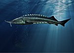
order Acipenseriformes. It is found primarily in the Caspian and Black Sea basins, and formerly in the Adriatic Sea. Based on maximum size, it is the third-most-massive...
25 KB (2,843 words) - 13:37, 11 May 2024

part of Central Asia and sits in the Balkhash-Alakol Basin, an endorheic (closed) basin. The basin drains seven rivers, the primary of which is the Ili...
41 KB (4,249 words) - 00:08, 8 April 2024