
055°W / 42.346; -71.055 The South Bay Harbor Trail is a mixed-use path in Boston, Massachusetts opened in 2011 The rail trail extends from Ruggles Station...
2 KB (212 words) - 08:30, 14 March 2022

Boston Harborwalk (redirect from Boston Harbor Walk)
Millers River Trail Somerville Community Path extension Rose Kennedy Greenway Walk to the Sea South Bay Harbor Trail Lower Neponset River Trail Quincy RiverWalk...
26 KB (2,060 words) - 00:25, 6 March 2024

The Marvin Braude Bike Trail (also known as the Beach Bike Path, Coastal Bike Trail, The Strand, or the South Bay Bicycle Trail) is a 22-mile (35 km) paved...
22 KB (2,036 words) - 05:00, 28 July 2024

Black Heritage Trail Archived July 2, 2010, at the Wayback Machine Boston National Historic Park The Boston Harbor Walk The Freedom Trail – Boy Scouts of...
8 KB (663 words) - 18:14, 30 April 2024

several important smaller bays, including Northport Bay, Suttons Bay, Omena Bay, Bowers Harbor, and Old Mission Bay. Northport Bay, located at the northwest...
15 KB (1,220 words) - 13:42, 30 July 2024

issue of the bay's size. Despite its value as a waterway and harbor, many thousands of acres of marshy wetlands at the edges of the bay were, for many...
55 KB (5,592 words) - 01:33, 5 August 2024

Francisco Bay Trail is a bicycle and pedestrian trail that when finished will allow continuous travel around the shoreline of San Francisco Bay. As of 2020...
7 KB (761 words) - 17:51, 4 January 2024
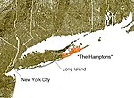
also used to name a trail that navigates the entirety of the South Fork (as well as parts of Long Island), the Paumanok Path. The South Fork and North Fork...
5 KB (626 words) - 09:50, 11 October 2023

Palm Harbor, Dunedin, Belleair, Clearwater, Largo, Seminole, South Pasadena, and Gulfport. It is utilized for walking, jogging, and cycling. Some trail users...
6 KB (532 words) - 01:00, 1 September 2023

Charlotte Flatwoods Environmental Park Charlotte Harbor Preserve State Park: North Cape Flats Trail Charlotte Harbor Preserve State Park: Little Pine Island Cayo...
6 KB (609 words) - 12:37, 21 May 2024

"Allegheny Trail Info". West Virginia Scenic Trails Association. 2021-01-24. Retrieved 2021-01-24The Allegheny Trail is a 288-mile north-south trail with its...
42 KB (537 words) - 19:55, 28 June 2024

0684222°W / 42.6278417; -71.0684222 The Bay Circuit Trail and Greenway or Bay Circuit is a Massachusetts rail trail and greenway connecting the outlying...
11 KB (975 words) - 00:03, 30 May 2024

Charlotte Harbor Estuary, the second largest bay in Florida, is located on the Gulf of Mexico coast of west Florida with two thirds lying in Charlotte...
16 KB (1,630 words) - 19:37, 11 July 2024

Raritan Bayshore (redirect from Sandy Hook Bay)
area around Raritan Bay from The Amboys to Sandy Hook, in Middlesex and Monmouth counties, including the towns of Perth Amboy, South Amboy, Sayreville,...
17 KB (1,502 words) - 22:46, 11 May 2024

The Back Bay is the colloquial term for the inland delta in Newport Beach, California. It connects the Upper Newport Bay with the Newport Harbor. It is...
16 KB (1,963 words) - 01:01, 4 January 2024

San Diego Bay is a natural harbor and deepwater port located in San Diego County, California, near the U.S.–Mexico border. The bay, which is 12 miles (19 km)...
19 KB (2,043 words) - 19:36, 12 August 2024

Harbor City is a highly diverse neighborhood in the South Bay and Harbor region of Los Angeles, California, with a population upward of 36,000 people....
14 KB (1,396 words) - 08:34, 2 July 2024

Bay is a large natural harbor and shallow estuary connected to the Gulf of Mexico on the west-central coast of Florida, comprising Hillsborough Bay,...
43 KB (4,304 words) - 18:51, 11 July 2024
Mexico at Clearwater Beach to areas near Tampa Bay at Safety Harbor. Parking is available where the trail runs by the Long Center, Coachman Ridge Park,...
3 KB (159 words) - 01:12, 28 May 2024

States. The trails are located south of Bodega Bay in Sonoma County. Automobile access from California State Route 1 is via Harbor Way just south of downtown...
2 KB (264 words) - 18:55, 17 May 2020
Beach. The bay is approximately two miles long and one third mile wide and features numerous marinas and private piers providing a safe harbor for boaters...
1 KB (216 words) - 17:08, 11 July 2019
of Sturgeon Bay. It was located on the south shore of Sturgeon Bay, an indentation of Lake Michigan, just west of where Sturgeon Bay Trail and Lakeshore...
6 KB (610 words) - 21:56, 6 August 2022
1957. It includes walking trails along Wellfleet Harbor of Cape Cod Bay as well as a nature center and a campground. Wellfleet Bay is located on land within...
6 KB (510 words) - 18:10, 5 June 2023

proposed as a possible source of the name. The bay has been referred to as Duwamish Bay and Seattle Harbor, especially before the US Board on Geographic...
19 KB (1,930 words) - 23:24, 8 July 2024

Cape Henlopen (category Delaware Bay)
Bay meets the Atlantic Ocean. Off the coast on the bay side are two lighthouses, called the Harbor of Refuge Light and the Delaware Breakwater East End...
10 KB (1,164 words) - 02:39, 3 May 2024
setting of wooded rolling sand hills approximately 3 miles (4.8 km) south of Good Harbor Bay and the Sleeping Bear Dunes National Lakeshore. The M-22, a State...
5 KB (573 words) - 00:05, 11 April 2024

(Jan 2002). "Ken Malloy Harbor Regional Park Improvement Program a Rescue Plan for the Most Precious Treasure of the South Bay". Proceedings of the Water...
11 KB (1,133 words) - 21:24, 11 April 2024

Kealakekua Bay is located on the Kona coast of the island of Hawaiʻi about 12 miles (19 km) south of Kailua-Kona. Settled over a thousand years ago, the...
25 KB (3,031 words) - 17:06, 21 March 2024

the city. WIS 42 Northbound travels to Egg Harbor, Fish Creek, Sister Bay, Ellison Bay and Gills Rock. South it travels to Algoma, Kewaunee, Two Rivers...
32 KB (2,652 words) - 01:16, 13 May 2024

Berkeley Marina (redirect from Berkeley Yacht Harbor)
Addison Street (one block south of University Avenue), and is traversed near Interstate 80 by a segment of the San Francisco Bay Trail. In addition, it is the...
9 KB (777 words) - 23:24, 22 April 2024