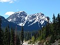
the community of McLeod Lake (Fort McLeod). It is at the head of the Crooked River, which flows north to McLeod Lake. Summit Lake is situated at the divide...
2 KB (165 words) - 13:49, 11 December 2023
Alta Lake (British Columbia) or Summit Lake Gates Lake or Summit Lake, Southern Interior Summit Lake (Crooked River), Central Interior Summit Lake (Vancouver...
3 KB (282 words) - 07:33, 18 December 2022
Land District: Summit Lake 52°19′00″N 123°34′00″W / 52.31667°N 123.56667°W / 52.31667; -123.56667 Summit Lake (Crooked River) Summit Lake 52°37′00″N 120°16′00″W...
2 KB (487 words) - 13:06, 4 November 2020
Lake (Salt Spring Island) Stuart Lake Stump Lake Sulphurous Lake Sumas Lake Summit Lake (Crooked River) Sustut Lake Swan Lake (Okanagan) Tagish Lake Takla...
11 KB (837 words) - 21:29, 31 July 2024
The Crooked River is a river in the Central Interior of British Columbia, Canada, beginning at Summit Lake and the community of the same name, flowing...
2 KB (228 words) - 16:11, 28 March 2024

of environmental resurgence". The name Cuyahoga is believed to mean "crooked river" from the Mohawk name Cayagaga, although the Mohawk were never in the...
72 KB (6,129 words) - 01:41, 2 August 2024

The Crooked River is a tributary, 125 miles (201 km) long, of the Deschutes River in the U.S. state of Oregon. The river begins at the confluence of the...
19 KB (2,036 words) - 15:06, 7 December 2020

Coos River Coquille River Crabtree Creek Crescent Creek Crooked River Cultus River D River Dead Indian Creek Dead River Deschutes River Dog River Donner...
97 KB (11,400 words) - 16:41, 4 August 2024

located in the Ozark Mountains along the banks of Crooked Creek, and neighbors the small town of Summit to the north. The population was 1,178 at the 2020...
21 KB (1,882 words) - 17:11, 24 July 2024

Chemung River Bentley Creek Seeley Creek South Creek Hammond Creek Tioga River Cowanesque River Troups Creek North Fork Cowanesque River Crooked Creek Mill...
73 KB (4,253 words) - 01:40, 15 May 2024

Grays River (Washington) Crooked Creek (Washington) Harlow's Creek (Washington): Formerly "Jim Crow Creek" Elochoman River (Washington) John Day River (Oregon)...
23 KB (1,609 words) - 19:52, 22 March 2024
Manson River Nation River Pack River McLeod Lake Crooked River Summit Lake McLeod River Carp Lake Parsnip River Misinchinka River Omineca River Mesilinka...
32 KB (2,458 words) - 22:19, 13 May 2024
the lake to Summit Lake. This flows via the Crooked River, McLeod River, Pack River, Williston Lake, Peace River, Slave River, Great Slave Lake and the...
2 KB (172 words) - 11:32, 5 November 2023

Harden Lake Cedar Lake Chamberlain Lake, St. Joseph County Chapman Lake, Kosciusko County Clear Lake, Steuben County Cordry Lake Crooked Lake, Steuben...
8 KB (759 words) - 21:03, 15 September 2023

Volcanoes–Fort Rock basin maar field". Deschutes & Ochoco National Forests – Crooked River National Grassland. United States Forest Service. 2004-01-09. Retrieved...
20 KB (1,662 words) - 14:02, 7 July 2023

Cowan Lake Crean Lake Cree Lake Crooked Lake Crystal Lake Culdesac Lake Cumberland Lake Cypress Lake Cyprian Lake Davey Lake Davin Lake Davy Lake Delaronde...
19 KB (937 words) - 19:54, 24 July 2024
Arkdale Lake (Millpond) Arrowhead Lake (Manchester) Big Roche A Cri Lake Camelot Lake Castle Rock Lake Crooked Lake Deep Lake Easton Lake Fawn Lake Fenner...
103 KB (12,380 words) - 16:35, 20 June 2024
Butter Creek Lake Creek (Packwood Lake) Muddy Fork Cowlitz River Ohanapecosh River Summit Creek Clear Fork Cowlitz River Kalama River Lewis River East Fork...
24 KB (2,328 words) - 09:49, 11 June 2024
Crooked Bum is a 6,937-foot-elevation (2,114 meter) mountain summit on the crest of the North Cascades in the U.S. state of Washington. It is located...
5 KB (473 words) - 21:32, 6 January 2024
"crooked streams" Quaboag River: (Nipmuck) "before the pond" or abbreviation of "red pond" (m'squ'boag) Quinebaug River: (Nipmuck) "long pond" Lake Quinsigamond:...
30 KB (3,164 words) - 09:16, 17 June 2024

Camp Creek (Fulton) Charlie's Trapping Creek (Fulton) Crooked Creek (Fulton and Gwinnett) Dog River (Douglas) Hewlett Creek (Fulton) Long Island Creek (Fulton)...
33 KB (3,048 words) - 15:22, 9 June 2024

Indian Reserve No. 2 McLeod Lake Indian Reserve No. 1 Parsnip Indian Reserve No. 5 Bear Lake Salmon Valley Summit Lake Willow River As a census division in...
19 KB (654 words) - 04:01, 7 July 2024

Lake Erie Basin consists of Lake Erie and surrounding watersheds, which are typically named after the river, creek, or stream that provides drainage into...
14 KB (1,125 words) - 03:36, 22 October 2023

Indiana into northwestern Ohio and Lake Erie. It is formed at the confluence of the St. Joseph and St. Marys rivers, where Fort Wayne, Indiana has developed...
20 KB (1,961 words) - 19:57, 22 July 2024
Applegate Lake in Jackson County Lake Billy Chinook Bull Run Lake and Mount Hood Cleawox Lake on the coast Cougar Reservoir on the South Fork McKenzie River Crater...
21 KB (209 words) - 07:22, 31 July 2024

Cumbrian toponymy (section Lakes)
'lake of the crooked river', linking the name with the River Cocker which flows through it. Related to Br *crumbaco Derwentwater named after the River...
23 KB (2,942 words) - 10:25, 1 May 2024
List of tautological place names (redirect from Lake lake)
Coosawhatchie River, South Carolina, United States (Hatchie = river) Cuyahoga River, Ohio (Cuyahoga derives from the Mohawk word for "crooked river") Fishkill...
53 KB (5,868 words) - 00:53, 25 July 2024

Mystery Mountain (Idaho) (category North American 2000 m summits)
from Highway 21 and from Stanley Lake. Precipitation runoff from the mountain drains to the Salmon River via Crooked Creek and Valley Creek. Topographic...
4 KB (255 words) - 23:45, 22 July 2024

Recreation Area Crooked Creek State Recreation Site Johnson Lake State Recreation Area Kasilof River State Recreation Site Kenai River Special Management...
8 KB (763 words) - 05:49, 2 August 2023

Cuyahoga Valley National Park (category Protected areas of Summit County, Ohio)
Portage Path was located in modern-day Summit County, Ohio. The trail connected the Cuyahoga and Tuscarawas Rivers and was approximately eight miles in...
68 KB (5,654 words) - 15:02, 31 July 2024