
Tamabil (Bengali: তামাবিল) is a hilly region in Sylhet on the border between Bangladesh and the Indian state of Meghalaya about 5 km from Jaflong. It stands...
3 KB (194 words) - 19:22, 4 July 2023

N2 (Bangladesh) (redirect from Dhaka-Sylhet Road)
capital Dhaka and the town of Tamabil in the Sylhet District at the Indian border. The route passes through the city of Sylhet, crossing the Surma River on...
7 KB (516 words) - 13:19, 17 July 2024
Jorabat NH 6: Jorabat - Shillong NH 206: Shillong - Dawki N2: Tamabil, Sylhet - Sylhet - Kanchpur - Dhaka N8: Dhaka-Mawa-Bhanga Expressway N804: Bhanga...
17 KB (994 words) - 22:51, 14 June 2024

(India) and Nakugaon post (Bangladesh) Shillong–Sylhet via Dawki integrated checkpost crossing (India) and Tamabil post (Bangladesh) Tripura Agartala–Dhaka via...
30 KB (2,584 words) - 09:51, 1 September 2024

other side inside Bangladesh the Tamabil bus station, 1.5 kilometres (0.93 mi) away, has regular bus service to Sylhet 55 kilometres (34 mi) away. Dawki...
6 KB (359 words) - 08:01, 29 August 2024

Bangladesh Last House (category Tourist attractions in Sylhet)
Bangladesh before the Bangladesh–India border at Jaintia Hill Resort, Tamabil, Sylhet District in Bangladesh. It has a view of two waterfalls with a mountain...
2 KB (103 words) - 20:41, 24 September 2023

Doboka — Jorabat NH 6: Jorabat — Shillong NH 206: Shillong — Dawki N2: Tamabil — Sylhet — Kanchpur — Dhaka N3: Dhaka — Joydebpur N4: Joydebpur — Tangail —...
13 KB (664 words) - 13:57, 16 July 2024
Jalalabad Cantonment, around eight kilometers northwest of Sylhet, beside the Sylhet - Tamabil Highway, and is temporarily set up at the campus of Jalalabad...
4 KB (327 words) - 12:40, 5 February 2024
Greater Sylhet region predominantly included the Sylhet Division in Bangladesh, and Karimganj district in Assam, India. The history of the Sylhet region...
68 KB (8,822 words) - 14:29, 11 September 2024

Sasaram – Kolkata – Petrapole – Benapole – Jashore – Dhaka – Kachpur – Sylhet – Tamabil – Dawki – Shillong – Jorabat (– Guwahati) – Nagaon – Dimapur – Chümoukedima...
37 KB (2,161 words) - 19:24, 31 August 2024
Mymensingh Koraitali, Mymensingh Nakugao, Sherpur Ramgarh, Khagrachari Tamabil, Sylhet Phuentsholing Dry Port, Phuentsholing Gelephu, Sarpang Gomtu, Samtse...
17 KB (1,273 words) - 12:09, 29 August 2024

tourist spot in Jaintiapur, Sylhet District, Bangladesh. Lalakhal is a wide channel in the Sharee River near the Tamabil road. The river is not very deep...
3 KB (100 words) - 17:29, 8 July 2024
Gowainghat Upazila (category Upazilas of Sylhet District)
Gowainghat (Bengali: গোয়াইনঘাট) is an upazila of Sylhet District in the Division of Sylhet, Bangladesh. The British Empire conquered the Jaintia Kingdom...
6 KB (499 words) - 15:58, 12 July 2024

formed at Koishal, India, opposite Sylhet border area. From 10, 2 October FA battery assisted Z Force in the Sylhet sector in direct fire support and ground...
22 KB (1,474 words) - 12:17, 2 September 2024

Kanaighat Upazila (category Upazilas of Sylhet District)
(Bengali: কানাইঘাট) is an upazila of Sylhet Division of Bangladesh. It is the second-largest upazila (sub-district) of Sylhet District after Gowainghat Upazila...
12 KB (1,207 words) - 16:51, 31 August 2024

Akhaura–Kulaura–Chhatak line (category Rail transport in Sylhet)
accessible from Sylhet and Srimangal. Tamabil-Dawki road border-crossing across the Bangladesh–India border is 55 km (34 mi) north of Sylhet. Fida, Quazi...
5 KB (384 words) - 12:38, 13 April 2024

Chittagong–Cox’s Bazar Expressway Gabtoli–Nabinagar–Paturia Expressway Tamabil–Gundum Expressway Gobrakura–Payra port Expressway Kotalipara–Mongla Port...
90 KB (220 words) - 13:17, 8 September 2024
alphabetical order by country. N2 (Bangladesh), connects Dhaka and Tamabil via Sylhet N2 road (Belgium), connects Brussels and Maastricht National Road...
2 KB (244 words) - 13:01, 5 January 2023

substation was established in 1954 on 5.00 acres of land in Chailakhal, Tamabil. The purpose was to collect and evaluate the selection and acceptance of...
5 KB (340 words) - 23:32, 2 September 2023

the Indian state of Meghalaya which adjoins the Tamabil area of the Bangladeshi border in the Sylhet district. Although an effective status quo had been...
28 KB (2,489 words) - 05:07, 13 September 2024

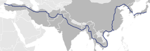
standards. The routes are: AH1: Tamabil to Benapole (492 kilometres (306 mi)), connecting to India at both ends. AH2: Tamabil to Banglabandha (517 kilometres...
57 KB (6,161 words) - 02:20, 1 July 2024

Independent Power Plant Project 60.0 ADB 3 April 2020 Bangladesh Sylhet to Tamabil Road Upgrade Project 404.0 None 3 April 2020 Uzbekistan Bukhara Region...
86 KB (5,962 words) - 18:32, 12 September 2024

Jaintiapur Upazila (category Upazilas of Sylhet District)
upazila of Sylhet District in the Division of Sylhet, Bangladesh. Jaintapur is widely recognized as a significant upazila within the Sylhet division of...
18 KB (2,197 words) - 17:28, 27 July 2024