Tasman Council is a local government body in Tasmania, situated in the south-east of the state. Tasman is classified as a rural local government area and...
6 KB (375 words) - 01:57, 19 April 2024
Tasman District Council (Māori: Te Kaunihera o te tai o Aorere) is the unitary local authority for the Tasman District of New Zealand. The council is led...
7 KB (437 words) - 15:47, 6 June 2024
up Tasman in Wiktionary, the free dictionary. Tasman most often refers to Abel Tasman (1603–1659), Dutch explorer. Tasman may also refer to: Tasman booby...
3 KB (453 words) - 16:16, 4 January 2024

Marlborough Region and Nelson City. It is administered by the Tasman District Council, a unitary authority, which sits at Richmond, with community boards...
19 KB (1,413 words) - 22:27, 4 August 2024

Abel Janszoon Tasman (Dutch: [ˈaːbəl ˈjɑnsoːn ˈtɑsmɑn]; 1603 – 10 October 1659) was a Dutch seafarer and explorer, best known for his voyages of 1642...
40 KB (4,811 words) - 02:34, 10 August 2024
The Tasman Peninsula, officially Turrakana / Tasman Peninsula, is a peninsula located in south-east Tasmania, Australia, approximately 75 km (47 mi) by...
10 KB (1,112 words) - 17:41, 24 May 2024

Trans-Tasman is an adjective used primarily to signify the relationship between Australia and New Zealand. The term refers to the Tasman Sea, which lies...
22 KB (2,476 words) - 00:58, 17 August 2024

Doo Town (category South-east area council geography stubs)
Archived 23 March 2012 at the Wayback Machine Totaltravel, Destinations, Tasman Peninsula & Port Arthur, Doo Town. "Doo Town Information and Attractions"...
4 KB (387 words) - 20:12, 9 February 2024

Tasman District Council in New Zealand. It lies 13 kilometres (8 mi) south of Nelson in the South Island, close to the southern extremity of Tasman Bay...
22 KB (1,490 words) - 03:46, 14 August 2024

The Tasman Bridge is a prestressed concrete girder bridge connecting the Tasman Highway over the River Derwent in Hobart, Tasmania, Australia. When it...
29 KB (2,955 words) - 04:00, 23 June 2024

Port Arthur, Tasmania (category Localities of Tasman Council)
Port Arthur is a town and former convict settlement on the Tasman Peninsula, in Tasmania, Australia. It is located approximately 97 kilometres (60 mi)...
25 KB (2,618 words) - 16:41, 1 July 2024
widespread controversy within Tasmania itself. Kelly Spaulding, mayor of the Tasman Council, which includes Port Arthur, condemned the choice to make the film....
20 KB (1,650 words) - 14:48, 10 July 2024
Clarence, Tasman Council Amalgamation (without GSBC) of; Sorell Council, City of Clarence, Tasman Council Amalgamation (without CoC) of; Sorell Council, Glamorgan–Spring...
12 KB (1,112 words) - 04:38, 6 August 2024
Shipstern Bluff (category Tasman Peninsula)
coast of Tasmania, Australia, on the Tasman Peninsula. Shipstern Bluff is located on the southern point of the Tasman Peninsula Tasmania, near Cape Raoul...
4 KB (349 words) - 13:21, 26 July 2024
Nubeena (category Localities of Tasman Council)
Nubeena is a town and fishing village on the Tasman Peninsula, Tasmania, Australia a township of Tasman Council, and seat of the municipality. At the 2016...
3 KB (241 words) - 09:45, 17 February 2023
Dunalley, Tasmania (category Localities of Tasman Council)
residential locality in the local government areas (LGA) of Sorell (37%) and Tasman (63%) in the South-east LGA region of Tasmania. The locality is about 31...
7 KB (521 words) - 16:56, 25 July 2024

The Tasman Highway (or A3) is a highway in Tasmania, Australia. Like the Midland Highway, it connects the major cities of Hobart and Launceston – however...
25 KB (1,378 words) - 10:33, 19 May 2024

Abel Tasman National Park is a national park at the north end of New Zealand's South Island. It covers 237.1 km2 (91.5 sq mi) of land between Golden Bay...
17 KB (1,779 words) - 02:58, 13 August 2024
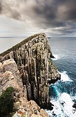
Cape Raoul (category Localities of Tasman Council)
a rural locality and a natural feature in the local government area of Tasman in the South-east region of Tasmania. It is located about 13 kilometres...
6 KB (547 words) - 16:44, 25 July 2024

Eaglehawk Neck (category Localities of Tasman Council)
officially Teralina / Eaglehawk Neck, is a narrow isthmus that connects the Tasman Peninsula with the Forestier Peninsula and hence to the rest of Tasmania...
9 KB (786 words) - 16:56, 25 July 2024

Retrieved 23 February 2018. "Local History – History of the Tasman Peninsula". Tasman Council. Retrieved 4 July 2015. "Port Arthur Historic Sites Statutory...
153 KB (16,556 words) - 15:31, 16 August 2024
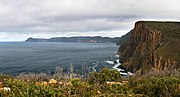
Cape Pillar (category Localities of Tasman Council)
Cape Pillar is a rural locality in the local government area (LGA) of Tasman in the South-east LGA region of Tasmania. The locality is about 27 kilometres...
5 KB (357 words) - 16:44, 25 July 2024

The mayor of Tasman is the head of the municipal government of Tasman District, New Zealand. The mayor is directly elected using the first-past-the-post...
5 KB (366 words) - 14:25, 3 May 2024

Banking regulation and supervision are co-ordinated through the Trans-Tasman Council on Banking Supervision and there are also ongoing discussions about...
135 KB (12,542 words) - 01:23, 5 August 2024

Forestier Peninsula (category South-east area council geography stubs)
to the Tasman Peninsula. The peninsula measures about 20 kilometres (12 mi) long by 15 kilometres (9.3 mi) wide, and is a part of the Tasman municipality...
4 KB (339 words) - 03:58, 25 April 2024
Fortescue, Tasmania (category Localities of Tasman Council)
Fortescue is a rural locality in the local government area of Tasman in the South-east region of Tasmania. It is located about 21 kilometres (13 mi) east...
3 KB (179 words) - 17:02, 25 July 2024
Murdunna (category Localities of Tasman Council)
Murdunna is a rural locality in the local government area (LGA) of Tasman in the South-east LGA region of Tasmania. The locality is about 36 kilometres...
4 KB (336 words) - 17:43, 25 July 2024
The Tasman Rugby Union is the governing body for rugby union in Tasman Bay / Te Tai-o-Aorere, a bay at the north end of the South Island in New Zealand...
33 KB (2,603 words) - 06:23, 18 August 2024
Boxalls Bay (category South-east area council geography stubs)
This Tasman Council geography article is a stub. You can help Wikipedia by expanding it....
1 KB (98 words) - 22:03, 17 October 2022
District Rangiora 19,600 Canterbury Waimakariri District Richmond 19,200 Tasman Tasman District Rolleston 29,600 Canterbury Selwyn District Timaru† 28,900...
26 KB (188 words) - 20:38, 1 August 2024