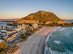
Tauriko is a suburb of Tauranga, in the Bay of Plenty Region of New Zealand's North Island. According to Place Names of New Zealand by A. W. Reed and...
5 KB (493 words) - 09:52, 4 October 2024
Maunganui, Arataki, Pāpāmoa, Welcome Bay, Matua-Otūmoetai, Bethlehem, Tauriko and Te Papa) and one Māori ward (Te Awanui, covering the entire city)....
58 KB (4,729 words) - 09:31, 4 October 2024

Retrieved 15 March 2014. "Tauranga City - the place to do business!". Tauriko Business Estate. Archived from the original on 9 December 2012. Auckland...
169 KB (14,149 words) - 23:27, 5 October 2024

Maunganui, Arataki, Pāpāmoa, Welcome Bay, Matua-Otūmoetai, Bethlehem, Tauriko and Te Papa) and one Māori ward (Te Awanui, covering the entire city) which...
20 KB (776 words) - 09:30, 27 August 2024

Bethlehem Judea Tauranga South Gate Pa Merivale Tauriko Greerton...
7 KB (576 words) - 06:53, 4 October 2024
shopping mall in Tauranga, New Zealand, located at 2 Taurikura Drive, Tauriko. It features more than 70 shops and 25 eateries. It has four anchor stores...
3 KB (284 words) - 05:27, 27 August 2024

The trust bought roughly 2150 square meters of land in the suburb of Tauriko for around $400,000. Despite being inaugurated in 2012, work on the actual...
32 KB (2,614 words) - 16:34, 6 October 2024

Zealand City Tauranga Local authority Tauranga City Council Electoral ward Tauriko General Ward Area • Land 129 ha (319 acres) Population (June 2023) • Total...
4 KB (392 words) - 09:52, 4 October 2024
Local authority Tauranga City Council Electoral ward Te Papa General Ward Tauriko General Ward Area • Land 421 ha (1,040 acres) Population (June 2023)...
9 KB (690 words) - 09:39, 4 October 2024
(Tauranga Harbour) Bellevue Te Puna Bethlehem Judea Tauriko Gate Pa...
14 KB (1,077 words) - 07:13, 4 October 2024
Zealand City Tauranga Local authority Tauranga City Council Electoral ward Tauriko General Ward Area • Land 1,086 ha (2,684 acres) Population (June 2023)...
12 KB (1,035 words) - 09:39, 4 October 2024

156 97 Tauranga Harbour Bridge Te Maunga 164 102 SH 29A – Maungatapu, Tauriko Tauranga Eastern Link begins Papamoa 171 106 (Domain Road / Te Puke Highway)...
25 KB (2,143 words) - 20:07, 28 September 2024

Tauranga (141,600): Omokoroa to Papamoa Beach; and Mount Maunganui to Tauriko and Pyes Pa Rotorua (59,500): Ngongotahā to Owhata Gisborne (37,200): Makaraka...
63 KB (2,910 words) - 00:15, 17 July 2024
176°06′08″E / 37.7379036°S 176.1021862°E / -37.7379036; 176.1021862 Tauriko Tauranga Bay of Plenty 2016 Unknown 45, 637 m2 (2 floors) 70 1,700 The...
110 KB (3,701 words) - 08:07, 15 July 2024

section (now SH 29A) and SH 36. SH 29 turns west through the village of Tauriko. From here SH 29 roughly follows the Wairoa River as it climbs the Kaimai...
14 KB (1,313 words) - 19:59, 25 August 2024
Kaimai Ranges Tapapa 20.8 SH 1 (12 km west of Tīrau) SH 2 at Tauranga Tauriko 53.7 Crosses the Kaimai Ranges. Route K (Takitimu Drive) became part of...
34 KB (323 words) - 19:58, 25 August 2024
Maunganui, Arataki, Pāpāmoa, Welcome Bay, Matua-Otūmoetai, Bethlehem, Tauriko and Te Papa) and one Māori ward (Te Awanui, covering the entire city),...
13 KB (1,073 words) - 09:40, 8 August 2024

Tauranga operates a toll road running between the outlying settlement of Tauriko on State Highway 2 and central business district of the city. This toll...
48 KB (6,242 words) - 16:08, 4 August 2024
School 1–8 Coed Welcome Bay State integrated 209 [49] 1187 1187 Tauriko School 1–8 Coed Tauriko State 266 - 1994 [50] Te Akau ki Papamoa Primary School 1–6...
51 KB (586 words) - 01:29, 11 November 2023
(7.83 sq mi). Parts of the statistical area were moved to the existing Tauriko and new Pyes Pa South West statistical areas for the 2023 census as Tauranga's...
6 KB (444 words) - 09:57, 4 October 2024
Maunganui Central Judea Te Reti Bethlehem South Omanu Beach Tauranga Hospital Tauriko Gate Pa Greerton South Tauranga South Arataki North Matapihi Pyes Pa West...
62 KB (4,617 words) - 09:01, 19 August 2024
Territorial authority Location km mi Exit Name Destinations Notes Tauranga City Tauriko SH 29 west – Hamilton, Auckland SH 29 north – City Centre, Port () SH 29A...
4 KB (344 words) - 20:00, 25 August 2024

(24 cu mi) Welded hard deposit almost reached Tokoroa in west and about Tauriko in north east. The vent still has some uncertainty and may be in the Ōkataina...
16 KB (1,596 words) - 21:43, 21 September 2024