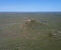
Thunder Butte (Lakota: Wakíŋyaŋ Pahá) is a prominent butte landmark located in the northwest corner of Ziebach County, South Dakota, in the United States...
10 KB (1,278 words) - 14:32, 10 March 2024

Cheyenne River Reservation. Their communities are Iron Lightning and Thunder Butte. Four Bear Creek, a tributary of the Missouri River, is located in the...
22 KB (1,795 words) - 00:21, 24 June 2024

across the Cheyenne River Indian Reservation, past Iron Lightning, Thunder Butte, Green Grass and Whitehorse. It joins the Missouri in Lake Oahe, with...
8 KB (405 words) - 01:16, 2 June 2024

(735 m) Saint Patrick Butte 2,356 feet (718 m) Squaw Teat Butte 2,365 feet (721 m) Thunder Butte 2,733 feet (833 m) U.S. Highway 212 South Dakota Highway...
15 KB (1,285 words) - 18:22, 27 April 2024

to eat the dead infected flesh in his wounds.[citation needed] Using Thunder Butte as a navigational landmark, Glass crawled overland south toward the...
26 KB (2,805 words) - 09:55, 31 July 2024
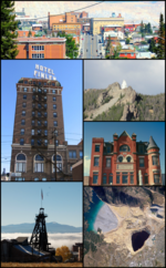
Butte (/bjuːt/ BEWT) is a consolidated city-county and the county seat of Silver Bow County, Montana, United States. In 1977, the city and county governments...
134 KB (12,255 words) - 00:45, 12 July 2024
Perkins County in the U.S. state of South Dakota. It is a tributary to Thunder Butte Creek. The headwaters arise at 45°32′01″N 102°19′42″W / 45.53361°N...
1 KB (177 words) - 12:23, 8 September 2021

Devil and Dr. O'Hara" (February 5) "Assassin" (March 4) "The Hanging at Thunder Butte Creek (March 18) "The Hostage" (September 9, 1956) Coy also appeared...
12 KB (1,045 words) - 23:39, 22 June 2024

NGVD 29 to NAVD 88. The summit of Thunder Butte is the highest point of Douglas County, Colorado. The elevation of Thunder Butte includes an adjustment of +1...
32 KB (3,828 words) - 20:51, 20 May 2024
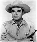
anthology series in the role of a sheriff in the episode "The Hanging at Thunder Butte Creek". In 1960, Bromfield retired from acting to produce sports shows...
8 KB (516 words) - 21:39, 24 June 2024
12,695' Thirtynine Mile Mountain 11,553' Thunder Butte 9,837' – highest summit of the Rampart Range Thunder Mountain 13,108' Tijeras Peak 13,610' Tomichi...
140 KB (11,156 words) - 04:12, 8 August 2024

south of the South Fork of the Grand River and near the headwaters of Thunder Butte Creek. It is just south of the Grand River National Grassland. According...
15 KB (888 words) - 20:30, 6 May 2024

the landform included Capital Butte, Gray Mountain, Grayback Mountain, and Judge Oteys Tombstone. Locals call it "Thunder Mountain." According to the Köppen...
5 KB (393 words) - 04:26, 2 July 2024
458 m) Thunder Butte, 48°13′16″N 109°07′27″W / 48.22111°N 109.12417°W / 48.22111; -109.12417 (Thunder Butte), el. 5,384 feet (1,641 m) Timber Butte, 48°15′18″N...
9 KB (2,257 words) - 06:15, 5 August 2024
Cheyenne River Reservation. Their communities are Iron Lightning and Thunder Butte. "History of the Southern Ute". Southern Ute Indian Tribe. Retrieved...
4 KB (401 words) - 06:22, 19 June 2023

the army, until the summer of 1907. The Ute were then moved to the Thunder Butte area of the Cheyenne River Indian Reservation. However, the situation...
21 KB (2,749 words) - 03:09, 26 April 2024
The community is just northeast of the confluence of Hart Creek and Thunder Butte Creek. A post office called Chance was established in 1901, and remained...
2 KB (150 words) - 21:47, 17 November 2023

burros", among other species. Other notable parks in the state include Bear Butte State Park near Sturgis and Lewis and Clark State Recreation Area near Yankton...
66 KB (5,938 words) - 20:28, 16 July 2024
Anaconda Copper (category Butte, Montana)
The novel Sweet Thunder (2013) by Ivan Doig recounts a journalistic duel between a union newspaper and a company newspaper in 1920s Butte. The term copper...
33 KB (4,294 words) - 08:02, 17 May 2024

Thunder Creek was a provincial electoral district for the Legislative Assembly of Saskatchewan, Canada. Originally created for the 3rd Saskatchewan general...
10 KB (156 words) - 21:47, 4 January 2024
Geological Survey Geographic Names Information System: Thunder Hawk Creek Black Horse Butte NW, SD, 7.5 Minute Topographic Quadrangle, USGS, 1972 Federal...
1 KB (104 words) - 17:27, 6 August 2024
Moose Jaw. Thunder Creek, a major tributary of the Moose Jaw River, begins west of the community. The town is served by the Central Butte Airport (TC...
8 KB (404 words) - 17:44, 16 July 2024

Thunderegg (redirect from Thunder egg)
A thunderegg (or thunder egg) is a nodule-like rock, similar to a filled geode, that is formed within rhyolitic volcanic ash layers. Thundereggs are rough...
8 KB (744 words) - 08:39, 26 December 2023
Prairie Junior Hockey League (redirect from Carrot River Outback Thunder)
PJHL. For example, the Pilot Butte Storm advanced to the finals eleven years (2005–15) in a row, while the Ochapawace Thunder (0-40-0-0) didn't win a game...
13 KB (434 words) - 13:34, 27 July 2024
one season due to lack of players) Eugene Thunder / Butte Roughriders (2000–11; franchise rights moved to Butte in 2003; folded in 2011) Fairbanks Ice Dogs...
12 KB (949 words) - 15:57, 10 January 2022

participated in the Army's November and December 1907 expedition to Thunder Butte, South Dakota, with the mission of "quieting" Ute Indians. He also served...
6 KB (689 words) - 05:09, 13 March 2024

through Prairie City. Almost immediately, it crosses over the South Fork Thunder Butte Creek. Approximately 1.2 miles (1.9 km) east of Divide Road, it crosses...
36 KB (3,314 words) - 16:14, 23 December 2023

Leander Creek Rush Creek Pine Creek Butte Creek Ponca Creek Choteau Creek Garden Creek Platte Creek White River White Thunder Creek Little White River Pine...
42 KB (2,052 words) - 05:19, 14 November 2023

Green Mountain Green Mountain (left) and Thunder Butte viewed from Pikes Peak Highest point Elevation 10,427 ft (3,178 m) Prominence 1,859 ft (567 m)...
3 KB (184 words) - 00:50, 23 December 2021
Grand Junction Jackalopes (redirect from Butte Copper Kings)
league becoming independent. The Butte Copper Kings, named for the once-powerful owners of the copper mines of Butte, Montana, began play in the Pioneer...
11 KB (698 words) - 17:56, 6 July 2024