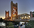
The Tower Bridge is a vertical lift bridge across the Sacramento River, linking West Sacramento in Yolo County to the west, with the capital of California...
15 KB (1,348 words) - 23:34, 31 August 2024

connecting West Sacramento, California and Downtown Sacramento. Since 1996, the highway has been legally defined to be the length of the Tower Bridge crossing...
21 KB (2,509 words) - 06:28, 22 August 2023

Shasta Bally is visible to the West looking upstream the Sacramento. The support tower of the bridge forms a single 217-foot (66 m) mast that points due north...
12 KB (1,224 words) - 03:37, 13 October 2024

seat of Sacramento County. Located at the confluence of the Sacramento and American Rivers in Northern California's Sacramento Valley, Sacramento's 2020...
160 KB (14,926 words) - 16:03, 17 October 2024

University Sacramento—DUS was a satellite campus of Drexel University, located in downtown Sacramento, California. It was in Old Sacramento, beside the Tower Bridge...
8 KB (635 words) - 01:46, 31 October 2023

part of the direct route between San Francisco and Sacramento. A second parallel cantilever bridge was completed in 1958 to deal with the increased traffic...
25 KB (2,681 words) - 20:10, 9 August 2024
The history of Sacramento, California, began with its founding by Samuel Brannan and John Augustus Sutter, Jr. in 1848 around an embarcadero that his father...
54 KB (6,873 words) - 13:02, 30 April 2024

Capitol Mall (category Transportation in Sacramento, California)
the Tower Bridge, and runs east to the California State Capitol. Capitol Mall begins at the eastern end of Tower Bridge, which crosses the Sacramento River...
20 KB (1,816 words) - 19:45, 18 September 2024

neighborhood of Sacramento, California located in the southernmost region of the city. It is adjacent to the Sacramento “City of Trees” Water Tower and home...
27 KB (2,575 words) - 19:43, 18 September 2024

located within the Old Sacramento State Historic Park, situated along the Sacramento River between the Tower Bridge and I Street Bridge. The museum originally...
9 KB (730 words) - 21:32, 6 June 2024

Sacramento River (Spanish: Río Sacramento) is the principal river of Northern California in the United States and is the largest river in California....
123 KB (12,490 words) - 03:58, 7 September 2024

West Sacramento (also known as West Sac) is a city in Yolo County, California, United States. The city is separated from Sacramento by the Sacramento River...
35 KB (3,091 words) - 09:31, 3 October 2024

The Sacramento Northern Railway (reporting mark SN) was a 183-mile (295 km) electric interurban railway that connected Chico in northern California with...
50 KB (6,249 words) - 20:00, 19 October 2024
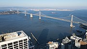
Francisco–Oakland Bay Bridge, commonly referred to as the Bay Bridge, is a complex of bridges spanning San Francisco Bay in California. As part of Interstate...
121 KB (13,184 words) - 06:04, 16 October 2024

over the Tower Bridge up to the door of the capitol but was once designated as SR 275. I-80 Bus/US 50/unsigned I-305 then crosses the Sacramento River on...
27 KB (2,351 words) - 19:43, 18 September 2024

I Street Bridge is a historic metal truss swing bridge which crosses the Sacramento River to link the capital city of Sacramento, California, with Yolo...
17 KB (1,612 words) - 16:40, 15 October 2024

12 across the Sacramento River at Rio Vista, California. The present bridge was completed in 1960 and is one of several moveable bridges spanning rivers...
24 KB (2,407 words) - 04:58, 27 March 2024
Sacramento Republic FC is an American professional soccer team based in Sacramento, California, that plays in the Western Conference of the USL Championship...
49 KB (3,862 words) - 04:22, 4 October 2024

Towers on Capitol Mall were two 53-story, 615 foot (187 m) mixed-use towers to be built in downtown Sacramento, California. The buildings (The Towers...
3 KB (297 words) - 14:09, 11 December 2023

Isleton is a city in Sacramento County, California, United States. The population was 794 at the 2020 census, down from 804 at the 2010 census. It is...
17 KB (1,611 words) - 19:11, 28 August 2024

Pocket) is a suburban community within the city of Sacramento, California, 5 miles south of downtown Sacramento. It is bordered by Interstate 5 on the east and...
23 KB (3,310 words) - 22:20, 17 June 2024
Forks of the Sacramento River. All locations are in California. Transport portal Engineering portal California portal "Sacramento River Bridge". bridgehunter...
14 KB (317 words) - 00:45, 14 October 2024
The following is a timeline of the history of the city of Sacramento, California, United States. 1839 – Sutter's Fort (or “New Helvetia”) established....
19 KB (1,479 words) - 15:51, 22 July 2024

baseball in Sacramento, California. Agricultural Park Occupants: Sacramento Eurekas – California State League (1883–1884) Sacramento Altas – California State...
4 KB (418 words) - 14:50, 30 September 2024

The San Mateo–Hayward Bridge (commonly called the San Mateo Bridge) is a bridge crossing the American state of California's San Francisco Bay, linking...
53 KB (4,912 words) - 22:23, 4 August 2024

self-anchored suspension bridge (SAS) and a pair of viaducts. The bridge is in the U.S. state of California and crosses the San Francisco Bay between Yerba Buena...
107 KB (12,498 words) - 15:58, 2 September 2024
September 2020). "New light rail line over Tower Bridge between Sacramento, West Sacramento moves forward". Sacramento Bee. Retrieved 15 September 2020. Downtown...
7 KB (589 words) - 19:50, 5 August 2024

northwest of Downtown Sacramento in Sacramento County, California, United States and covers 6,000 acres (2,400 ha). It serves the Sacramento Metropolitan Area...
85 KB (6,274 words) - 10:24, 18 October 2024

Highway, stretching from West Sacramento, California, in the west to Ocean City, Maryland, in the east. The California portion of US 50 runs east from...
63 KB (6,126 words) - 20:39, 9 September 2024

state of California that consists of two unconnected segments, one in the San Francisco Bay Area and the other primarily in the Sacramento–San Joaquin...
24 KB (1,815 words) - 15:37, 2 August 2024