
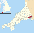
Trerulefoot (pronounced /ˈtruːlfʊt/, Cornish: Bentreriwall) is a village in southeast Cornwall, England, United Kingdom. It is located on the A38 trunk...
1 KB (137 words) - 19:43, 14 August 2023

section became part of an extended A361. A374 Marsh Mills, Plymouth Trerulefoot Runs through Union Street, Plymouth. Originally followed the current...
54 KB (56 words) - 15:45, 8 July 2024
company currently has outlet stores from Loch Lomond in Scotland, to Trerulefoot in southeast Cornwall. Pavers continues to be a family-run business,...
6 KB (550 words) - 16:59, 1 May 2024

(2,400 ha) which extends into the neighbouring villages of Tideford, Trerulefoot and Polbathic. Both house and garden are Grade I listed. Originally built...
6 KB (503 words) - 04:38, 15 March 2024

with the A38 trunk road, from the outskirts of Plymouth in Devon to the Trerulefoot roundabout in Cornwall. Starting at the Marsh Mills junction of the A38...
5 KB (591 words) - 23:08, 13 February 2023
Trenoweth, Isles of Scilly, Trenwheal, Trequite, Trerair, Trerise, Trerose, Trerulefoot, Tresamble, Tresarrett, Tresavean, Tresawle, Tresawson, Trescoll, Trescowe...
45 KB (1,828 words) - 12:56, 26 June 2024

Polbathic (Cornish: Polbarthek) is a small village situated on the A374 Trerulefoot to Torpoint road, within the parish of St Germans, in south-east Cornwall...
2 KB (183 words) - 13:57, 17 September 2023
Shop is a hamlet in Cornwall, England. It is half a mile northwest of Trerulefoot. According to the Post Office the 2011 census population was included...
1 KB (70 words) - 06:15, 20 April 2023
Council PL12 SALTASH Saltash, Hatt, Landrake, St Germans, Tideford, Trerulefoot Cornwall Council PL13 LOOE Looe, Lansallos, Polperro Cornwall Council...
8 KB (199 words) - 09:37, 3 September 2023

Tideford Cricket Club who re-located from a site they had been using near Trerulefoot. The views from the ground stretch out to the East as far as Maker Church...
14 KB (1,637 words) - 16:03, 1 June 2024

double back on themselves after taking the main A38 road from Plymouth at Trerulefoot and onto the A374. There are no main railway stations within the area;...
5 KB (598 words) - 11:12, 29 May 2024

bypass, stretching for 6 miles (10 km) from the west of Liskeard to Trerulefoot, opened in June 1976. A public inquiry was held for the Dobwalls bypass...
62 KB (7,772 words) - 18:18, 4 July 2024

Tideford Cricket Club who re-located from a site they had been using near Trerulefoot. The club made the press in the late 70s when they were able to put out...
5 KB (611 words) - 05:08, 27 March 2024
Lakes or Bake Pools; is the name for a group of lakes at Bake Farm, near Trerulefoot, Cornwall, England, UK. There are seven lakes in total; they are used...
1 KB (123 words) - 08:23, 4 July 2024

reference SX 321 585, 1 kilometre (0.62 mi) south-west of the A38/A374 Trerulefoot roundabout. Bake is the seat of the Moyle family (although Bake itself...
3 KB (199 words) - 22:30, 9 June 2024
records that the proposed railway was to commence at a new junction at Trerulefoot, 1+3⁄4 miles (2.8 km) west of St Germans although GWR plans indicate...
10 KB (1,146 words) - 14:24, 14 November 2023
Western Railway considered constructing a new seven-mile branch from Trerulefoot, near St Germans, to Looe, in the 1930s. This was coupled with an awareness...
37 KB (5,053 words) - 16:23, 18 July 2024
and St Germans. St Germans and Landulph represented the villages of Trerulefoot, Polbathic, St Germans, Tideford, Landrake, Pillaton, Botusfleming, and...
6 KB (163 words) - 09:10, 8 December 2021

Limit) Order 1999 (Revocation) Order (SI 2010/1351) The A38 Trunk Road (Trerulefoot Roundabout to Carkeel Roundabout, Cornwall) (40 and 50 MPH Speed Restrictions)...
214 KB (31,547 words) - 06:51, 8 December 2023
2012/54 - A38 Trunk Road (Trerulefoot Roundabout to Stoketon Cross, Near Saltash) (Temporary Prohibition and Restriction of Traffic) Order 2012 In Force...
20 KB (242 words) - 06:51, 8 December 2023
Order (SI 2009/3349) The London – Penzance Trunk Road (A38) (Dobwalls to Trerulefoot Roundabout) (Prohibition of Waiting) (Clearways) Order 1978 (Variation)...
190 KB (27,374 words) - 23:54, 8 January 2024
(England) (Amendment) Regulations (SI 2011/833) The A38 Trunk Road (Trerulefoot to Liskeard, Cornwall) (Temporary Prohibition and Restriction of Traffic)...
335 KB (49,601 words) - 06:51, 8 December 2023
Cornwall 50°06′N 5°06′W / 50.10°N 05.10°W / 50.10; -05.10 SW7827 Trerulefoot Cornwall 50°23′N 4°22′W / 50.39°N 04.36°W / 50.39; -04.36 SX3258 Tresaith...
82 KB (26 words) - 18:29, 22 June 2024