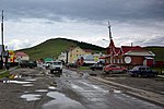
Ulagan (Russian: Улага́н, Altay: Улаган) is a rural locality (a selo) and the administrative center of Ulagansky District of the Altai Republic, Russia...
3 KB (656 words) - 09:58, 24 January 2023

Republic in Russia by the Telengits. It is widespread in the Kosh-Agach and Ulagan districts of the Altai Republic. The Telengit are also known as the Telengit-kiji...
9 KB (453 words) - 07:26, 28 July 2024

Its maximum lifetime is 800–850 years. Pinus sibirica Ulagansky Pass near Ulagan, Russia Pinus sibirica in Ergaki, Ermakovskiy district Siberian pine, Pinus...
6 KB (575 words) - 13:50, 18 August 2024
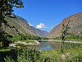
Ulagansky District (Russian: Улага́нский райо́н; Altay: Улаган аймак, Ulagan aymak) is an administrative and municipal district (raion), one of the ten...
7 KB (941 words) - 09:59, 24 January 2023
Ulan (Mongolian: ᠬᠣᠲᠠ; born November 1962), also romanized as Ulagan, or Wulan (Chinese: 乌兰; pinyin: Wūlán), is a Chinese politician of Mongol heritage...
3 KB (376 words) - 11:59, 14 August 2024
streets. Saratan is located 30 km southeast of Ulagan (the district's administrative centre) by road. Ulagan is the nearest rural locality. Карта Улаганского...
3 KB (88 words) - 23:21, 19 December 2022
earthquake on December 20, 1761. Landslides affected the Kosh-Agachsky and Ust’-Ulagan Districts. List of earthquakes in 2003 List of earthquakes in Russia ISC...
5 KB (305 words) - 17:17, 28 July 2024

streets. Balyktyul is located 16 km northeast of Ulagan (the district's administrative centre) by road. Ulagan is the nearest rural locality. "Карта села Балыктуюля...
4 KB (112 words) - 23:15, 19 December 2022

into a rocky canyon. The mean annual flow rate near the village of Ust’-Ulagan measures about 30 cubic metres per second (1,100 cu ft/s). It is widely...
2 KB (248 words) - 02:36, 29 June 2022
район selo of Turochak 12484 Ulagansky District Улаганский район selo of Ulagan 11388 Ust-Kansky District Усть-Канский район selo of Ust-Kan 15007 Ust-Koksinsky...
276 KB (538 words) - 09:46, 27 July 2024

documented by modern archaeologists include the kurgans at Pazyryk in the Ulagan (Red) district of the Altai Republic, south of Novosibirsk in the Altai...
198 KB (21,803 words) - 01:31, 11 August 2024
first sites discovered by modern archaeologists were the kurgans Pazyryk, Ulagan district of the Altay Republic, south of Novosibirsk. The name Pazyryk culture...
50 KB (5,835 words) - 23:37, 28 July 2024

as of 2016. There are 11 streets. Chibit is located 63 km southwest of Ulagan (the district's administrative centre) by road. Aktash is the nearest rural...
3 KB (92 words) - 23:22, 19 December 2022

including how to ethnically classify them. It was the political leaders of the Ulagan district who first advocated that the Telengits be recognized as a separate...
12 KB (1,212 words) - 07:27, 28 July 2024

is located on the southern slope of Kuray Mountains, 55 km southwest of Ulagan (the district's administrative centre) by road. Chibit is the nearest rural...
4 KB (114 words) - 14:44, 11 June 2023

Koo is located on the left bank of the Chulyshman River, 84 km north of Ulagan (the district's administrative centre) by road. The village is inhabited...
3 KB (108 words) - 23:19, 19 December 2022
276 as of 2016. There are 2 streets. Pasparta is located 34 km north of Ulagan (the district's administrative centre) by road. Balyktuyul is the nearest...
3 KB (90 words) - 23:19, 19 December 2022

Balyktyul Bele Chibilya Chibit Kara-Kudyur Kokbesh Koo Pasparta Saratan Ulagan Yazula Rural localities in Ust-Kansky District: Bely Anuy Chyorny Anuy Karakol...
8 KB (494 words) - 21:39, 12 August 2024
streets. Chibilya is located 3 km southwest of Ulagan (the district's administrative centre) by road. Ulagan is the nearest rural locality. Карта села Чибиля...
3 KB (100 words) - 23:22, 19 December 2022

Zhang Daili 张岱梨 1954 ♀ Han — — 150 Chen Quanguo 陈全国 1955 — Han — — 151 Ulagan 乌兰 1958 ♀ Mongolian — — 152 Fu Zhifang 付志方 1956 — Han — — 153 Xia Baolong...
139 KB (1,035 words) - 12:59, 23 July 2024
information about this phenomenon is documented. Yazula is located 87 km east of Ulagan (the district's administrative centre) by road. Saratan is the nearest rural...
3 KB (160 words) - 23:23, 19 December 2022
9 streets. Balykcha is located on the Chulyshman River, 115 km north of Ulagan (the district's administrative centre) by road. Kordon Atyshtu is the nearest...
4 KB (115 words) - 23:16, 19 December 2022
of 2016. There are 4 streets. Kara-Kudyur is located 13 km northwest of Ulagan (the district's administrative centre) by road. Chibilya is the nearest...
3 KB (96 words) - 23:17, 19 December 2022
the Lake Teletskoye in the valley of the Barchik creek, 125 km north of Ulagan (the district's administrative centre) by road. Kordon Atyshtu is the nearest...
4 KB (131 words) - 23:16, 19 December 2022