
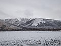
The Ulakhan-Sis Range (Russian: Улахан-Сис; Yakut: Улахан Сис) is a mountain range in the Sakha Republic, Far Eastern Federal District, Russia. This range...
4 KB (369 words) - 03:46, 7 June 2024
north of the Arctic Circle, there is a branch of the main range running northwards named Ulakhan Sis. It is about 100 kilometres (62 mi) long and its highest...
4 KB (389 words) - 21:32, 2 January 2024

Krasnoyarsk Krai Sail Rock, Krasnodar Krai Taganay National Park, Chelyabinsk Ulakhan-Sis, Yakutia, topped by kigilyakh formations Đavolja Varoš (Devil's Town)...
22 KB (1,725 words) - 18:27, 22 May 2024

Siberian Islands Oymyakon Highlands Polousny Range Stolbovoy Island, Laptev Sea Suor Uyata range Ulakhan Sis Outside of Yakutia, similar formations are...
7 KB (574 words) - 10:04, 5 December 2023
East Siberian Mountains (section Ranges)
Range Chibagalakh Range Nendelgin Tas-Kystabyt Upper Kolyma Highlands Angachak Range Kyun-Tas Polousny Range Kondakov Plateau Suor Uyata Ulakhan-Sis Range...
7 KB (595 words) - 00:14, 23 January 2024

such as Muostakh Island, Stolbovoy Island, Kotelny Island and the Ulakhan-Sis Range, as well as in scattered places of the Yana-Indigirka Lowland. In...
3 KB (353 words) - 09:14, 27 March 2024

Verkhoyansk Range (Russian: Верхоянский хребет, Verhojanskiy Hrebet; Yakut: Үөһээ Дьааҥы сис хайата, Üöhee Caaŋı sis xayata) is a mountain range in the Sakha...
10 KB (976 words) - 16:17, 4 May 2024
4,170 square kilometres (1,610 sq mi). It has its sources in the Ulakhan-Sis Range and flows roughly northeastwards across the Kondakov Plateau. Leaving...
4 KB (320 words) - 15:35, 28 March 2024
Suor Uyata (redirect from Ulakhan-Tas)
kilometers (12 mi) to the east of the eastern end of the Ulakhan-Sis Range. It is a smaller range than the latter, of which it can be considered an eastern...
5 KB (432 words) - 10:06, 5 December 2023

of the Indigirka. It has its sources in the northern slopes of the Ulakhan-Sis range. The river flows first northwestwards in its uppermost section, and...
4 KB (295 words) - 16:09, 28 March 2024
original sources of the uppermost river in the network are in the Ulakhan-Sis Range. The Rassokha flows across the Middle Kolyma District and the Lower...
4 KB (269 words) - 16:57, 5 June 2022
delta of the Indigirka to the north. To the south it is bound by the Ulakhan-Sis Range and by the Kolyma Lowland to the east. The Kondakov Plateau is crossed...
5 KB (526 words) - 06:17, 19 May 2023

highest peak is 968 metres (3,176 ft) high. In the east, the Ulakhan-Sis, a prolongation of the range on the other side of the Indigirka River, stretches eastwards...
5 KB (470 words) - 10:05, 5 December 2023
Ulakhan-Sis ranges of the East Siberian Lowlands, Maydell reached the Indigirka. Going about 100 km (62 mi) upriver he found out that the Ulakhan-Sis...
3 KB (299 words) - 21:44, 16 January 2023

the Moma and the Chersky ranges. Meanwhile Maydell crossed the Kolyma Lowland. He charted the Suor-Uyata and Ulakhan-Sis ranges of the lowlands, reaching...
9 KB (1,006 words) - 07:24, 10 November 2023

break the generally flat relief, including the Kyundyulyun, Polousny Range, Ulakhan-Sis, Kondakov Plateau and Suor Uyata, as well as by isolated hills rising...
8 KB (859 words) - 13:12, 21 February 2024

Taba-Bastaakh in the southern slopes of the Ulakhan-Sis. It flows roughly southwards away from the range, first following its southern flank eastwards...
4 KB (394 words) - 21:14, 16 January 2023
of the Yana-Indigirka Lowland and Kolyma Lowland. The Polousny Range and the Ulakhan-Sis are located to the south and the Kondakov Highland rises to the...
10 KB (1,318 words) - 09:24, 17 June 2023