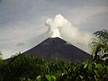
Ulawun is a basaltic and andesitic stratovolcano in West New Britain Province, on the island of New Britain in Papua New Guinea. About 130 km (81 mi) southwest...
6 KB (582 words) - 13:03, 2 August 2024
largely formed by volcanic processes, and has active volcanoes including Ulawun (highest volcano nationally), Langila, the Garbuna Group, the Sulu Range...
19 KB (1,986 words) - 17:59, 27 August 2024
Teide Nyiragongo Vesuvius Etna Santorini Unzen Sakurajima Taal Merapi Ulawun Mauna Loa Colima Santa María Avachinsky Koryaksky Galeras Rainier The Decade...
18 KB (1,388 words) - 02:52, 8 October 2024

Manila Bulletin. Retrieved 1 March 2020. "Ulawun". Global Volcanism Program. Smithsonian Institution. "Ulawun volcano (New Britain, Papua New Guinea) activity...
48 KB (1,924 words) - 14:21, 14 September 2024

A stratovolcano in Ulawun on the island of New Britain in Papua New Guinea...
83 KB (8,731 words) - 05:52, 3 October 2024
ancient Mount Kapberg stratovolcano. Mount Kapberg Sulu Range Hargy Bamus Ulawun Ulawun is one of the several Decade Volcanoes. Likuruanga Tavurvur It recently...
33 KB (2,769 words) - 18:29, 27 September 2024
death toll List of volcanic eruptions by death toll Lists of volcanoes "Ulawun". Global Volcanism Program. Smithsonian Institution. "Rabaul". Global Volcanism...
76 KB (1,973 words) - 08:25, 27 September 2024

Cyclades, Greece Taal Volcano, Luzon, Philippines Teide, Canary Islands, Spain Ulawun, New Britain, Papua New Guinea Mount Unzen, Nagasaki Prefecture, Japan Vesuvius...
90 KB (10,068 words) - 16:05, 6 October 2024
Quetrupillán 2,350 7,710 Chile Mount Malabar 2,343 7,687 Java, Indonesia Ulawun 2,334 7,657 New Britain, Papua New Guinea – highest mountain in the Bismarck...
37 KB (59 words) - 10:13, 2 August 2024
Popomanaseu 2335 m 7661 ft 5302 0.0568 Solomon Islands 52 New Britain Mount Ulawun 2334 m 7657 ft 36520 0.0216 Papua New Guinea 53 Adelaide Island Mount Gaudry...
78 KB (253 words) - 22:41, 27 September 2024
20°E / -4.12; 152.20 (Tavui) 5150 BC Ulawun 2334 7657 5°03′S 151°20′E / 5.05°S 151.33°E / -5.05; 151.33 (Ulawun) 2023 Unnamed - - 4°45′S 150°51′E /...
10 KB (69 words) - 21:39, 13 July 2024
islands are generally mountainous. The highest point on New Britain is Mount Ulawun at 2,334 m (7,657 ft), and the highest point on New Ireland is Mount Taron...
7 KB (722 words) - 01:53, 30 September 2024

Santorini, Cyclades; Taal Volcano, Luzon Volcanic Arc; Teide, Canary Islands; Ulawun, New Britain; Mount Unzen, Nagasaki Prefecture; Mount Vesuvius, Naples);...
65 KB (4,457 words) - 23:24, 11 July 2024

Bamus Volcano is a volcano on New Britain near Ulawun. It last erupted in 1886. It is classified as a stratovolcano and noted to have a breached crater...
948 bytes (71 words) - 15:42, 13 November 2023

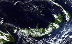
Ulawun Volcano and Lolobau Island in the Bismarck Sea....
8 KB (684 words) - 13:44, 20 August 2024

nasa.gov. 18 January 2003. Retrieved 10 August 2017. "Plume rises from Ulawun : Natural Hazards". Earthobservatory.nasa.gov. 30 November 2012. Retrieved...
7 KB (602 words) - 16:53, 16 July 2024

group. It is located just north of New Britain island in the archipelago. Ulawun is an active volcano across the strait from Lolobau Island. Bismarck Archipelago...
2 KB (185 words) - 21:13, 31 July 2024
point in West Papua and the Bird's Head Peninsula. The active stratovolcano Ulawun is the apex of New Britain in Papua New Guinea. Mount Kosciuszko is the...
13 KB (695 words) - 08:22, 5 July 2024
Likuruanga Left to right: Likuruanga, Ulawun and Bamus. Lolobau Island is at the bottom of image. Highest point Elevation 904 m (2,966 ft) Coordinates...
2 KB (101 words) - 19:42, 19 June 2022

volcanoes are still active. The islands are generally mountainous, with Mount Ulawun on New Britain reaching 2,334 m (7,657 ft). The portions of New Britain...
6 KB (520 words) - 03:15, 16 April 2024
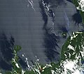
Pago volcano. On the right there is a steam plume over the sea from the Ulawun volcano. Highest point Elevation 400 m (1,300 ft) Coordinates 5°3′20″S 150°6′30″E...
3 KB (316 words) - 13:20, 2 August 2024
Ireland The arc volcanoes are grouped into western, Willaumez Peninsula-Mount Ulawun and Rabaul areas. The Gazelle Volcanic Zone extends for 65 km (40 mi) across...
16 KB (1,323 words) - 00:50, 23 March 2024