Umiat (OO-mee-yat) is an unincorporated community in North Slope Borough, Alaska, United States. It is located on the Colville River, 140 miles southwest...
12 KB (652 words) - 11:31, 9 May 2024
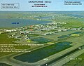
Umiat Airport (IATA: UMT, ICAO: PAUM, FAA LID: UMT) is a state owned, public use airport located in Umiat, in the North Slope Borough of the U.S. state...
6 KB (372 words) - 23:27, 14 January 2021

Principal meridians of Alaska (redirect from Umiat meridian)
Kateel River meridian (adopted 1956), Seward meridian (adopted 1911) and Umiat meridian (adopted 1956).[citation needed] List of principal and guide meridians...
2 KB (124 words) - 23:40, 10 December 2021

(Borough seat) Wainwright Point Lay Prudhoe Bay Alpine Deadhorse Sagwon Umiat The borough has a single school district: North Slope Borough School District...
23 KB (1,954 words) - 18:45, 27 August 2024

in Alaska. The detachment's mission was: Do a detailed geologic study at Umiat and Cape Simpson Drill test and core holes Drill a deep well Do complete...
189 KB (20,115 words) - 02:20, 17 October 2024

precipitation in this place is about 5 times that of places such as Utqiagvik and Umiat. Atigun Pass, after an avalanche. "Gold Rush Days and Endless Nights at...
7 KB (305 words) - 01:49, 25 January 2024

and Allakaket, Yukon-Koyokuk, Alaska April −50 °F (−46 °C) April 5, 1995 Umiat, North Slope, Alaska May −25 °F (−32 °C) May 5, 1992 Chandalar Lake, Yukon-Koyukuk...
52 KB (5,737 words) - 02:49, 15 October 2024

14306; -151.73361. It is in Section 18, Township 15 South, Range 2 East, Umiat Meridian, within the Utqiaġvik Recording District. According to the United...
23 KB (1,847 words) - 20:57, 17 July 2024

forays in 1943. Starting in 1944, the U.S. Navy funded oil exploration near Umiat Mountain, on the Colville River in the foothills of the Brooks Range. Surveyors...
96 KB (11,492 words) - 04:24, 27 September 2024

Meridian) Utah Umiat Meridian 1956 69°23′29.654″N 152°00′04.55″W / 69.39157056°N 152.0012639°W / 69.39157056; -152.0012639 (Umiat Meridian) Alaska...
53 KB (6,039 words) - 19:16, 28 August 2024

Skagway Seaplane Base Summit Tanacross Tokeen Seaplane Base Ugashik Bay Umiat Waterfall Seaplane Base Yankee Creek Zachar Bay Seaplane Base Government...
31 KB (2,349 words) - 05:51, 24 September 2024
the Navy drilled eighty wells, including the area at Cape Simpson and Umiat but none flowed more than 250 barrels per day. The discovery of the Swanson...
40 KB (3,876 words) - 03:02, 15 August 2024
Skagway Seaplane Base Summit Tanacross Tokeen Seaplane Base Ugashik Bay Umiat Waterfall Seaplane Base Yankee Creek Zachar Bay Seaplane Base Government...
3 KB (221 words) - 13:45, 23 September 2024
Skagway Seaplane Base Summit Tanacross Tokeen Seaplane Base Ugashik Bay Umiat Waterfall Seaplane Base Yankee Creek Zachar Bay Seaplane Base Government...
89 KB (5,502 words) - 21:42, 23 October 2024

Grande, Oregon in 1948. In 1951, he moved to Alaska, living in Fairbanks and Umiat. From 1951 to 1953, he served in the United States Army Signal Corps. In...
5 KB (358 words) - 03:28, 24 August 2024
Skagway Seaplane Base Summit Tanacross Tokeen Seaplane Base Ugashik Bay Umiat Waterfall Seaplane Base Yankee Creek Zachar Bay Seaplane Base Government...
20 KB (1,399 words) - 20:31, 15 October 2024

Skagway Seaplane Base Summit Tanacross Tokeen Seaplane Base Ugashik Bay Umiat Waterfall Seaplane Base Yankee Creek Zachar Bay Seaplane Base Government...
29 KB (2,909 words) - 15:38, 21 October 2024

Skagway Seaplane Base Summit Tanacross Tokeen Seaplane Base Ugashik Bay Umiat Waterfall Seaplane Base Yankee Creek Zachar Bay Seaplane Base Government...
8 KB (543 words) - 19:19, 15 October 2024

Skagway Seaplane Base Summit Tanacross Tokeen Seaplane Base Ugashik Bay Umiat Waterfall Seaplane Base Yankee Creek Zachar Bay Seaplane Base Government...
50 KB (4,440 words) - 20:40, 31 July 2024
Tanana, Tatalina, Tin City, Trinity, Tunalik, Tungak, Tyonek, Ugashik, Umiat, Unalakleet, Ungalik, Utopia Creek (Indian Mountain), Valdez, Wainwright...
25 KB (2,597 words) - 04:31, 10 October 2024

Skagway Seaplane Base Summit Tanacross Tokeen Seaplane Base Ugashik Bay Umiat Waterfall Seaplane Base Yankee Creek Zachar Bay Seaplane Base Government...
18 KB (1,718 words) - 20:33, 15 October 2024
the Colville River, which it joins about 17 miles (27 km) northeast of Umiat. List of rivers of Alaska "Chulitna River". Geographic Names Information...
3 KB (115 words) - 19:30, 17 May 2021

Skagway Seaplane Base Summit Tanacross Tokeen Seaplane Base Ugashik Bay Umiat Waterfall Seaplane Base Yankee Creek Zachar Bay Seaplane Base Government...
6 KB (547 words) - 09:35, 10 February 2024
Skagway Seaplane Base Summit Tanacross Tokeen Seaplane Base Ugashik Bay Umiat Waterfall Seaplane Base Yankee Creek Zachar Bay Seaplane Base Government...
8 KB (599 words) - 02:34, 24 June 2024
WNC Naukati Bay Seaplane Base (was Nichin Cove Seaplane Base) Umiat UMT UMT PAUM Umiat Airport Valdez L93 Robe Lake Seaplane Base Wasilla D75 Blodgett...
67 KB (758 words) - 14:07, 4 September 2024

Skagway Seaplane Base Summit Tanacross Tokeen Seaplane Base Ugashik Bay Umiat Waterfall Seaplane Base Yankee Creek Zachar Bay Seaplane Base Government...
42 KB (4,675 words) - 15:43, 20 October 2024

southeastern border of the National Petroleum Reserve. At the Iñupiat village of Umiat it turns north to flow across the Arctic plain, entering the western Beaufort...
14 KB (1,296 words) - 17:12, 10 April 2024

Skagway Seaplane Base Summit Tanacross Tokeen Seaplane Base Ugashik Bay Umiat Waterfall Seaplane Base Yankee Creek Zachar Bay Seaplane Base Government...
18 KB (1,538 words) - 14:21, 22 August 2024
1824 Florida Alabama Uintah 109°56′06″W 40°25′59″N 1875 Utah (part of NE) Umiat 152°00′04.551″W 69°23′29.654″N 1956 Alaska Ute 108°31′59″W 39°06′23″N 1880...
18 KB (449 words) - 09:51, 16 July 2024

Skagway Seaplane Base Summit Tanacross Tokeen Seaplane Base Ugashik Bay Umiat Waterfall Seaplane Base Yankee Creek Zachar Bay Seaplane Base Government...
44 KB (4,777 words) - 11:36, 15 October 2024