
The Upper Harbour Local Board is one of the 21 local boards of the Auckland Council, and is one of the two boards overseen by the council's Albany Ward...
10 KB (768 words) - 10:23, 26 June 2024
Upper Harbour is a local government area in Auckland, in New Zealand's Auckland Region, governed by the Upper Harbour Local Board and Auckland Council...
2 KB (115 words) - 07:26, 18 December 2023

The Upper Harbour Bridge (also called the Greenhithe Bridge) is a motorway bridge in west Auckland, New Zealand. It is technically two bridges, spanning...
5 KB (479 words) - 21:52, 8 November 2023

Hobsonville (category Upper Harbour Local Board Area)
west and the Upper Harbour Bridge in the east. Hobsonville is a peninsula between the Upper Waitematā Harbour and the central Waitematā Harbour. Hobsonville...
22 KB (2,294 words) - 00:02, 24 May 2024

The Upper Waitematā Harbour is an estuary of the Waitematā Harbour in the Auckland Region of New Zealand. It flows south-east from the town of Riverhead...
15 KB (1,329 words) - 08:00, 25 April 2024
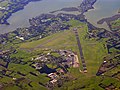
Whenuapai (category Upper Harbour Local Board Area)
North Island of New Zealand. It is located on the shore of the Upper Waitematā Harbour, 15 kilometres to the northwest of Auckland's city centre. It is...
18 KB (1,941 words) - 06:55, 28 April 2024
his resignation in June 2015. The party had two members on the Upper Harbour Local Board in Auckland from 2013 to 2016. The party has contested the four...
90 KB (8,205 words) - 02:25, 3 July 2024

the Waitematā Harbour. West Harbour is under the governance of Auckland Council after the amalgamation of district councils in 2010. Local features include...
8 KB (631 words) - 05:41, 1 May 2024

Lucas Creek (category Upper Harbour Local Board Area)
Lucas Creek is a stream and tidal estuary of Upper Waitematā Harbour in the Auckland Region of New Zealand's North Island. It flows through Albany on...
19 KB (1,682 words) - 23:29, 10 May 2024

Oruamo or Hellyers Creek (category Upper Harbour Local Board Area)
Oruamo or Hellyers Creek is a stream and tidal estuary of Upper Waitematā Harbour in the Auckland Region of New Zealand's North Island. It flows through...
10 KB (915 words) - 07:58, 25 April 2024

The Upper Harbour local board area in Auckland has the lowest concentration of Māori people at 6.1%, followed by the Devonport-Takapuna local board area...
121 KB (12,389 words) - 15:12, 26 June 2024
Rosedale, Auckland (redirect from North Harbour, New Zealand)
Albany. It is under the local governance of the Auckland Council. Northern Rosedale is also known by the name Upper Harbour. The business and light industrial...
11 KB (1,193 words) - 07:52, 18 December 2023
2023 New Zealand census (section Population counts by territorial authority and Auckland local board areas)
Rodney local board area 66,417 77,949 11,532 17.4 Auckland - Hibiscus and Bays local board area 104,010 114,033 10,023 9.6 Auckland - Upper Harbour local board...
35 KB (2,028 words) - 00:18, 19 June 2024

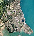
Herald Island, New Zealand (category Populated places around the Waitematā Harbour)
acres (40 ha) in the Upper Waitematā Harbour in Auckland, New Zealand. Herald Island is located in the Upper Waitematā Harbour between Whenuapai (to...
8 KB (944 words) - 05:05, 22 April 2024
State Highway 18 (New Zealand) (redirect from Upper Harbour Motorway)
carriageway Upper Harbour Drive. The motorway heads south-west, crossing the upper reaches of the Waitematā Harbour over the Upper Harbour Bridge. At Squadron...
5 KB (279 words) - 22:11, 9 June 2024

The Howick local board area of Auckland has the highest concentration of Chinese people at 25.6%, followed by the Upper Harbour local board area (23.6%)...
32 KB (3,271 words) - 22:43, 20 June 2024
Local Board; 4 each from the Hibiscus Coast and East Coast Bays subdivisions: 6 candidates were elected as members of the Upper Harbour Local Board:...
54 KB (583 words) - 07:06, 30 June 2024
Shore Action (section Devonport-Takapuna local board)
beyond the North Shore for the Upper Harbour Local Board. Of the two candidates that ran for the Devonport-Takapuna Local Board both were elected. However...
17 KB (1,415 words) - 16:55, 28 November 2023

Albany, New Zealand (category Populated places around the Waitematā Harbour)
Auckland Council, Albany is a part of the Upper Harbour local government area governed by the Upper Harbour Local Board. It is a part of the Albany ward, which...
49 KB (4,895 words) - 06:08, 28 June 2024
metropolitan area in northern New Zealand. New Zealand State Highway 18 (Upper Harbour Highway) passes to the north of the suburb, and the Albany Highway to...
6 KB (510 words) - 09:27, 26 May 2024
members were elected to local boards in the 2013 Auckland local board elections, an election held as part of the 2013 New Zealand local elections. This table...
41 KB (58 words) - 09:37, 14 May 2024

Greenhithe, New Zealand (redirect from Upper Harbour Primary School)
Council, Greenhithe is a part of the Upper Harbour local government area governed by the Upper Harbour Local Board. It is a part of the Albany ward, which...
34 KB (3,308 words) - 02:39, 21 June 2024

Auckland Council (redirect from Local boards of Auckland Council)
of Auckland in public hands (after the deregulation of the Auckland Harbour Board) to fund the improvements with the dividends. Until 2010, the Auckland...
73 KB (6,169 words) - 11:13, 4 July 2024
New Zealand City Auckland Local authority Auckland Council Electoral ward Albany ward Local board Upper Harbour Local Board Area • Land 163 ha (403 acres)...
6 KB (494 words) - 19:02, 18 December 2023
The Upper Harbour local board area of Auckland had the highest concentration of Korean people at 6.9%, followed by the Devonport-Takapuna local board area...
18 KB (1,866 words) - 22:02, 19 June 2024
North Shore, directly west of Albany, and is located in the Albany ward for local government purposes. There is evidence of a Pā on the north bank of Lucas...
3 KB (193 words) - 11:23, 13 May 2024
New Zealand City Auckland Local authority Auckland Council Electoral ward Albany ward Local board Upper Harbour Local Board Area • Land 84 ha (208 acres)...
6 KB (587 words) - 14:58, 8 June 2024

Wellington Harbour Board was the body which formerly managed the shipping and commercial affairs of the port of Wellington in New Zealand. It was constituted...
52 KB (4,842 words) - 16:43, 29 June 2024
Brian Neeson (category Waitemata District Health Board members)
Auckland elections, Neeson was elected to the Upper Harbour Local Board and the Waitematā District Health Board. Orsman, Bernard (5 July 2002). "Key electorate:...
7 KB (567 words) - 20:07, 10 April 2024
of the Upper Harbour local government area, which also administers northeastern West Auckland, and is governed by the Upper Harbour Local Board. The East...
111 KB (10,008 words) - 03:34, 21 May 2024