Vermont Route 121 (VT 121) is a state highway in the U.S. state of Vermont. The highway runs 21.439 miles (34.503 km) from VT 11 in Londonderry east to...
7 KB (555 words) - 03:24, 19 March 2023

crossed by Interstate 91 (Exit 5 serves the town), U.S. Route 5, Vermont Route 121 and Vermont Route 123. The New England Central Railroad has track rights...
16 KB (1,161 words) - 22:11, 24 July 2024
elevation. The town is crossed by Interstate 91, U.S. Route 5, Vermont Route 103 and Vermont Route 121. The Bellows Falls train station was once served by...
19 KB (1,857 words) - 06:16, 7 July 2024
Route 121 or Highway 121 can refer to multiple roads: National Route 121 New Brunswick Route 121 Ontario Highway 121 Prince Edward Island Route 121 National...
5 KB (336 words) - 15:13, 9 April 2024

The entire route is in Chittenden County. Vermont Route 2B (VT 2B) is an alternate route of US 2 between Danville and St. Johnsbury. The route begins across...
25 KB (1,463 words) - 01:41, 5 August 2024

(275 km) from Montpelier, Vermont, beginning at US 2, to Portland, Maine, at U.S. Route 1. It passes through the states of Vermont, New Hampshire and Maine...
25 KB (1,430 words) - 22:28, 4 August 2024

Highways, and Vermont routes. Routes in Vermont are abbreviated as "VT #" by VTrans and also abbreviated as "VT Route #" and "Route #" in common usage...
62 KB (1,082 words) - 15:16, 10 July 2024

Vermont (/vərˈmɒnt/ vər-MONT) is a state in the New England region of the Northeastern United States. It borders Massachusetts to the south, New Hampshire...
217 KB (21,695 words) - 16:22, 12 August 2024

Vermont Route 30 (VT 30) is a 111.870-mile-long (180.037 km) north–south state highway in the U.S. state of Vermont. VT 30 runs from U.S. Route 5 (US...
11 KB (546 words) - 02:03, 26 July 2024
Londonderry. Vermont Route 35 (Chester Hill Road) runs north out of Grafton, leading 7 miles (11 km) to Chester. Route 35 joins Route 121 east out of Grafton...
4 KB (205 words) - 02:06, 11 July 2023

Windham County is a county located in the U.S. state of Vermont. As of the 2020 census, the population was 45,905. The shire town (county seat) is Newfane...
28 KB (2,323 words) - 19:02, 30 April 2024

Vermont Route 35 (VT 35) is a 21.220-mile-long (34.150 km) north–south state highway in southeastern Vermont, United States. It runs from an intersection...
4 KB (215 words) - 03:10, 19 March 2023

Killington is a town in Rutland County, Vermont, United States. The population was 1,407 at the 2020 census. Killington Ski Resort and numerous vacation...
9 KB (833 words) - 03:58, 11 May 2024

Interstate 89 (redirect from Interstate 89 (Vermont))
Montpelier, the state capital of Vermont; and Burlington, Vermont. I-89 is one of three main Interstate highways whose route is located entirely within New...
40 KB (3,126 words) - 13:01, 28 July 2024

New England road marking system (redirect from New England Interstate Route 17)
then U.S. Route 4, Vermont Route 30, U.S. Route 7, U.S. Route 2, and Vermont Route 225. Route 30A was superseded by Vermont Route 22A, and Route 30B was...
158 KB (6,445 words) - 17:10, 1 February 2024

South Burlington is a city in Chittenden County, Vermont, United States. Along with neighboring Burlington, it is a principal city of the Burlington metropolitan...
23 KB (2,145 words) - 22:48, 26 July 2024

Vermont Route 12 (VT 12) is a 101.627-mile-long (163.553 km) north-south state highway in Vermont that runs from Weathersfield to Morrisville. Route 12...
9 KB (258 words) - 23:11, 23 May 2024

Vermont Route 122 (VT 122) is a state highway in the U.S. state of Vermont. The highway runs 15.215 miles (24.486 km) from U.S. Route 5 (US 5) and VT...
7 KB (533 words) - 03:24, 19 March 2023

Saxtons River (category Rivers of Vermont)
stone dam, and joins the river near where Vermont Route 121 is crossed by Interstate 91 List of rivers of Vermont U.S. Geological Survey. National Hydrography...
7 KB (742 words) - 22:20, 1 April 2024

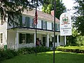
the early industrial areas of Grafton, Vermont. Located a short way east of Grafton Village on Vermont Route 121, it includes ten well-preserved 19th-century...
4 KB (412 words) - 00:47, 8 August 2023

Vermont Route 120 (VT 120) is a 10.554-mile-long (16.985 km) state highway located in Franklin County, Vermont, United States. The route begins at an intersection...
5 KB (496 words) - 03:24, 19 March 2023

Interstate 93 (redirect from Interstate 93 (Vermont))
Highway in the New England states of Massachusetts, New Hampshire, and Vermont in the United States. Spanning approximately 190 miles (310 km) along a...
77 KB (5,923 words) - 21:17, 28 July 2024

Vermont Route 11 (VT 11) is a 42.154-mile-long (67.840 km) east–west state highway in Vermont, United States. The western end of the highway is at VT...
11 KB (798 words) - 21:24, 18 October 2022
The town is crossed by Interstate 91, U.S. Route 5, Vermont Route 12, Vermont Route 44, and Vermont Route 44A. It is bordered by the town of Weathersfield...
24 KB (1,941 words) - 00:40, 6 May 2024

1926, the former Route 2 was commissioned as US 5. At this point, the road was not paved. It was not paved until the state of Vermont started overseeing...
27 KB (1,631 words) - 14:48, 17 February 2024
in Windham County, Vermont. List of National Historic Landmarks in Vermont National Register of Historic Places listings in Vermont National Park Service...
42 KB (212 words) - 00:24, 12 December 2023

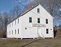
on the north side of Main Street (Vermont Route 121), just west of its junction with Chester Road (Vermont Route 35). It stands west of the former Grafton...
3 KB (327 words) - 15:59, 15 June 2024

Vermont Route 14 (VT 14) is a 108.946-mile-long (175.332 km) north–south state highway in northeastern Vermont, United States. It extends from U.S. Route...
22 KB (2,070 words) - 04:10, 7 June 2024

Lake Carmi (redirect from Lake Carmi, Vermont)
third largest peat bog in Vermont. At the southern end of the lake, Lake Carmi State Park offers camping facilities. Vermont Route 120 runs along the northern...
3 KB (281 words) - 11:27, 18 July 2022

by a freeway segment of U.S. Route 4, from which three interchanges serve the town. Vermont Route 4A and Vermont Route 22A also pass through Fair Haven...
13 KB (1,135 words) - 04:08, 11 May 2024