
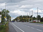
Walkley Road (Ottawa Road #74) is a major road in Ottawa, Ontario, Canada. It runs from Riverside Drive to Ramseyville Road (formerly Baseline Road)....
849 bytes (76 words) - 12:08, 12 April 2023
Conroy Road is a road in the City of Ottawa, Ontario, Canada. It runs from Walkley Road in the north to Bank Street in the south. Conroy Road forms the...
1 KB (182 words) - 06:03, 3 December 2023

billion and employed about 10,000 people. Its headquarters are located on Walkley Road in Ottawa. In 2018, the company opened a 600,000-square-foot (55,742 m2)...
18 KB (2,110 words) - 21:32, 3 August 2024
Walkley is a suburb of Sheffield, England, west of Burngreave, south of Hillsborough and north-east of Crookes. The area consists mainly of Victorian...
7 KB (948 words) - 19:12, 18 December 2022
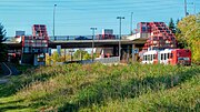
Walkley is a bus station on Ottawa's transitway served by OC Transpo buses. It is located in the south-eastern transitway section at Walkley Road in Ottawa...
7 KB (189 words) - 08:35, 30 July 2024

Walkley Library is a public lending library in Walkley, a suburb of the City of Sheffield in England. It stands at the junction of Walkley Road and South...
7 KB (1,026 words) - 21:41, 10 February 2024
Ottawa, Ontario, Canada. It is located in the south end of the city on Walkley road close to the intersection of Bank street. The Ottawa Jr. Senators of...
5 KB (454 words) - 20:03, 29 July 2024

Heron Road (Ottawa Road #16) is a major road in Ottawa, Ontario, Canada. It runs from Walkley Road at an angle to the Rideau River, where it turns into...
2 KB (218 words) - 11:46, 15 July 2024

St. Laurent Boulevard (category Roads in Ottawa)
slightly east of south, until it reaches Walkley Road. It then curves west and intersects with Conroy Road and Don Reid Drive. In Ottawa, the name of...
4 KB (511 words) - 22:12, 20 July 2024

Dolan Parkway Thomas Argue Road Trail Road Trim Road Vanier Parkway Veterans Memorial Highway (416) Victoria Street Walkley Road Waller Street Wellington...
14 KB (478 words) - 14:38, 25 July 2024
ward Walkley Road, a major road in Ottawa, Ontario, Canada Walkley Line, a bypass rail line operated by CNR in Ottawa, Ontario, Canada Walkley Library...
878 bytes (152 words) - 03:44, 18 April 2023

maintains many regional roads, like most counties and regional municipalities in Southern and Eastern Ontario. The regional road system was created by the...
44 KB (607 words) - 02:16, 29 December 2023
dedicated rights-of-way shared with Ottawa Central freight trains south of Walkley Yard, which occasionally serve the National Research Council of Canada's...
54 KB (4,400 words) - 08:19, 4 July 2024
Albion Road North, at Walkley Road. It runs only a short distance as a local road before being interrupted by the railway tracks and the Walkley O-Train...
6 KB (661 words) - 13:45, 15 July 2024

Association are that part of Alta Vista Ward south of Smyth Road in the north, north of Walkley Road and east of the Rideau River (and Bank Street), and west...
10 KB (853 words) - 17:24, 19 July 2024

Ottawa, Ontario, Canada. It is bounded by Walkley Road on the north, the Transitway on the west, Albion Road on the east, and Ledbury Park on the south...
7 KB (583 words) - 04:46, 26 January 2023

Airport Parkway (Ottawa) (category Infobox road maps tracking category)
meets Walkley Road with a partial interchange. After that, it is flanked by residential neighbourhoods before interchanging with Brookfield Road, and the...
8 KB (493 words) - 02:39, 3 September 2024

west by St. Laurent Boulevard, on the northeast by Russell Road and on the south by Walkley Road. According to the Canada 2016 Census, the population of...
5 KB (340 words) - 18:54, 3 January 2024

located on the south-western corner of the junction of Montague Road and Walkleys Road. Designated by the Metropolitan Adelaide Development Plan as a "District...
11 KB (1,411 words) - 04:17, 7 September 2024
which led to the Fitzgerald Inquiry. For this work, Dickie won the Gold Walkley in 1987. On 12 January 1987, The Courier-Mail published a front page story...
9 KB (811 words) - 15:44, 4 August 2024

Premier Sir Thomas Playford. The suburb (and one adjacent main road) is named after John Walkley, an early pioneer in South Australia The suburb had a population...
3 KB (289 words) - 18:35, 16 December 2023

south of Walkley Road is known as Riverside Park South. According to the Canada 2011 Census, the population of the neighbourhood north of Walkley (Census...
3 KB (343 words) - 05:10, 26 January 2023

Walkley Road and east of Conroy Road; the townships of Osgoode and Rideau; the northwest part of the Township of Cumberland lying north of Innes Road...
20 KB (1,194 words) - 20:01, 22 July 2024

Walkley is an electoral ward in Sheffield, South Yorkshire, England. Walkley ward—which includes the districts of Netherthorpe, Upperthorpe, Walkley and...
3 KB (306 words) - 11:58, 6 June 2024

A monument to John Innes was erected at the corner of Russell Road and Walkley Road in 1941, but was not maintained and it was removed when Gloucester...
6 KB (687 words) - 11:41, 15 July 2024

railway rights of way through Ottawa in exchange for land near Walkley Road, where the Walkley Train Yard would be extended. This reduced the number of trains...
41 KB (3,963 words) - 04:03, 25 July 2024

Walkley Yard was built in 1955 at a size of 129 acres and 9000 feet in length by the National Capital Commission to relocate the Canadian National Railway...
3 KB (238 words) - 08:35, 30 July 2024

Bank Street (Ottawa) (redirect from Ottawa Road 31)
Ottawa Road 16 (Heron Road) Ottawa Road 103 (Alta Vista Drive) Walkley Road Ottawa Road 32 (Hunt Club Road) Albion Road Ottawa Road 125 (Conroy Road) Ottawa...
11 KB (1,127 words) - 17:22, 26 February 2024
of Walkley Road south of Baseline Road. It also included part of the city of Gloucester north of Leitrim Road between Limebank Road and Conroy Road. It...
2 KB (180 words) - 13:33, 29 May 2024
neighbourhood of Ottawa, Ontario, Canada, at the intersection of Walkley Road and Heron Road. Prior to redevelopment in the mid-2010s, it was the site of...
9 KB (862 words) - 18:45, 23 August 2022