Warroo is a rural locality in the Goondiwindi Region, Queensland, Australia. In the 2021 census, Warroo had a population of 39 people. The locality was...
3 KB (106 words) - 02:53, 31 May 2024

The Shire of Warroo was a local government area in the Darling Downs region of Queensland, Australia. In March 2008, it became part of the new Maranoa...
4 KB (309 words) - 03:49, 28 January 2021

Warroo Shire Hall is a heritage-listed town hall at cnr Cordelia & William Streets, Surat, Maranoa Region, Queensland, Australia. It was designed by Harry...
13 KB (1,833 words) - 04:24, 5 February 2023
Warroo Parish is a remote civil Parish, of Irrara County, a cadasteral division of New South Wales. Warroo Parish is on the Queensland-New South Wales...
2 KB (200 words) - 21:27, 21 November 2020

1847, the first cattle stations were established: Burgorah (also known as Warroo, owned by Robert Fitzgerald and managed by Patrick Brennan); Boombah (owned...
38 KB (3,356 words) - 04:02, 1 September 2024

602352)". Queensland Heritage Register. Queensland Heritage Council. Retrieved 11 July 2013. "Warroo Shire Hall (entry 602612)". Queensland Heritage Register...
21 KB (1,864 words) - 16:47, 30 August 2024

Shire of Pine Rivers (redirect from Pine Rivers, Queensland)
kilometres (12 mi) north of Brisbane in the Moreton Bay region of South East Queensland, Australia. The shire covered an area of 771 square kilometres (297.7 sq mi)...
16 KB (1,473 words) - 03:28, 12 May 2024
numbers. In 1923 it reopened as a half-time school sharing a teacher with the Warroo Road Provisional School (formerly the Coolmunda Provisional School). From...
5 KB (363 words) - 11:36, 26 May 2024
shared a single teacher). Whycombe Provisional School closed in 1907 and Warroo Provisional School became a full-time school, but then closed too circa...
5 KB (389 words) - 05:06, 31 May 2024

areas in Queensland, see List of former local government areas of Queensland. Queensland portal List of former local government areas of Queensland List of...
28 KB (185 words) - 09:12, 8 August 2024
rural town and locality in the Goondiwindi Region, Queensland, Australia. It is on the border of Queensland and New South Wales. In the 2021 census, the locality...
5 KB (395 words) - 08:16, 15 June 2024
Pikedale is a rural locality in the Southern Downs Region, Queensland, Australia. It is one of the areas used for soldier settlements following service...
12 KB (1,122 words) - 23:58, 4 August 2024

Shire of Maroochy (redirect from Maroochy Shire, Queensland)
(62 mi) north of Brisbane in the Sunshine Coast region of South East Queensland, Australia. The shire covered an area of 1,162.7 square kilometres (448...
10 KB (747 words) - 00:27, 3 January 2024

Shire of Bendemere (category Former local government areas of Queensland)
amalgamated with the Town of Roma and the Shires of Booringa, Bungil and Warroo to form the Maranoa Region. The Shire of Bendemere was established on 12...
4 KB (371 words) - 05:38, 27 January 2023

Shire of Belmont (redirect from The Shire of Belmont, Queensland)
The Shire of Belmont is a former local government area of Queensland, Australia, located in eastern Brisbane including the current suburb of Belmont. The...
5 KB (466 words) - 13:26, 18 March 2024

Oman-ama and Omanama) is a rural locality in the Goondiwindi Region, Queensland, Australia. In the 2021 census, Oman Ama had a population of 31 people...
9 KB (650 words) - 06:23, 29 May 2024
coordinates) Glenlyon is a rural locality in the Southern Downs Region, Queensland, Australia. In the 2021 census, Glenlyon had a population of 32 people...
9 KB (749 words) - 17:07, 25 July 2024

County of Bentinck (redirect from County of Bentinck, Queensland)
located on the southern boundary of the state of Queensland, Australia. Like all counties in Queensland, it is a non-functional administrative unit, that...
6 KB (161 words) - 01:41, 18 December 2023

was a local government area located in the Wide Bay–Burnett region of Queensland, Australia, containing the urban locality of Maryborough as well as the...
19 KB (1,521 words) - 08:01, 29 August 2024
Terrica is a rural locality in the Goondiwindi Region, Queensland, Australia. In the 2021 census, Terrica had a population of 29 people. The locality takes...
3 KB (168 words) - 22:50, 30 May 2024

City of Redcliffe (category Former local government areas of Queensland)
The City of Redcliffe is a former local government area in South East Queensland, Australia. In 2008, it was amalgamated with the Shires of Pine Rivers...
14 KB (1,026 words) - 21:51, 18 June 2024

Town of Windsor (category Former local government areas of Queensland)
The Town of Windsor is a former local government area of Queensland, Australia, located in northern Brisbane. On 11 February 1887, a portion of the Ithaca...
5 KB (531 words) - 16:28, 18 July 2024

Shire of Jondaryan (redirect from Jondaryan Shire, Queensland)
Jondaryan was a local government area located in the Darling Downs region of Queensland, Australia, immediately west of the regional city of Toowoomba. The shire...
8 KB (722 words) - 01:12, 24 January 2021

City of Thuringowa (redirect from Thuringowa, Queensland)
/ -19.30722; 146.73167) was a city and local government area in North Queensland, Australia covering the northern and western parts of what is now Townsville...
15 KB (1,156 words) - 01:11, 19 August 2023

Shire of Booringa (category Former local government areas of Queensland)
Bendemere; the Shire of Booringa; the Shire of Bungil; and the Shire of Warroo. On 26 July 2009, Roma Region was renamed Maranoa Region. The Shire of Booringa...
6 KB (518 words) - 01:50, 27 July 2022
Pikes Creek is a rural locality in the Southern Downs Region, Queensland, Australia. In the 2021 census, Pikes Creek had a population of 19 people. The...
5 KB (386 words) - 17:55, 25 July 2024
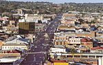
City of Toowoomba (category Former local government areas of Queensland)
Toowoomba was a local government area in the Darling Downs region of Queensland, Australia, encompassing the centre and inner suburbs of the regional...
6 KB (482 words) - 12:07, 12 March 2024

City of Bundaberg (category Former local government areas of Queensland)
was a local government area located in the Wide Bay–Burnett region of Queensland, Australia, encompassing the centre and inner suburbs of the regional...
7 KB (658 words) - 23:41, 18 July 2024

Town of Roma (category Former local government areas of Queensland)
Bendemere; the Shire of Booringa; the Shire of Bungil; and the Shire of Warroo. On 26 July 2009, Roma Region was renamed Maranoa Region. 1867: T. McEwen...
5 KB (432 words) - 11:22, 13 March 2023

City of Gympie (category Former local government areas of Queensland)
City of Gympie is a former local government area in the south-east of Queensland, Australia, responsible for governing Gympie. On 11 November 1879, the...
8 KB (831 words) - 04:36, 4 September 2023