
Wasdale Screes is a Site of Special Scientific Interest (SSSI) within the Lake District National Park in Cumbria, England. This protected area includes...
3 KB (249 words) - 23:04, 15 January 2025
54°25′30″N 3°21′00″W / 54.425°N 3.350°W / 54.425; -3.350 Wasdale (/ˈwɒzdeɪl/; traditionally /ˈwɒsəl, ˈwɒʃdəl/) is a valley and civil parish in the...
6 KB (555 words) - 01:07, 31 January 2025
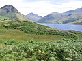
Wast Water (redirect from Wastwater Screes)
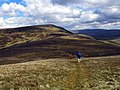
Rigg and Illgill Head, are known as the "Wastwater Screes" or on some maps as "The Screes". These screes formed as a result of ice and weathering erosion...
9 KB (979 words) - 00:03, 6 February 2025

Wastwater Screes across Wastwater is one of the most famous and awe-inspiring views in England. Poet Norman Nicholson described the Screes as ‘like the...
4 KB (399 words) - 23:59, 5 February 2025

on its northern side. This group also includes the Wastwater Screes overlooking Wasdale, the Glaramara ridge overlooking Borrowdale, the three tops of...
97 KB (9,980 words) - 03:48, 31 January 2025

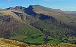
dramatic landscapes in that the rugged and impressive Wastwater Screes (also known as "The Screes") fall from the fells summit to Wast Water over 450 m (1,500 ft)...
5 KB (542 words) - 00:03, 6 February 2025

Windsor Farm into Nether Wasdale. Nether Wasdale contains the hotels the Screes Inn, the Strands Hotel and Low Wood Hall. Nether Wasdale was historically a...
6 KB (349 words) - 23:27, 30 January 2025
SSSI Armboth Fells SSSI Skiddaw Group SSSI Helvellyn & Fairfield SSSI Wasdale Screes SSSI (Wast Water is a separate SAC protecting the lake) Scafell Pikes...
5 KB (613 words) - 11:43, 26 January 2025

obstruct the view northward. The Scafells are well seen, as are the Wasdale Screes. From Overbeck Bridge on the Wastwater road a way can be found up to...
6 KB (801 words) - 00:03, 6 February 2025

Upper Solway Flats & Marshes Waberthwaite Quarry Wan Fell Wart Barrow Wasdale Screes Wast Water Water Crag Wedholme Flow Wet Sleddale Meadows Whitbarrow...
116 KB (1,056 words) - 19:34, 30 December 2024
Head Rannerdale Knotts Raven Crag Red Pike (Buttermere) Red Pike (Wasdale) Red Screes Rest Dodd Robinson Rossett Pike Rosthwaite Fell Sail Saint Sunday...
23 KB (2,842 words) - 18:49, 25 May 2024
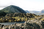
The view across Wastwater to the screes of Whin Rigg and Illgill Head is excellent. Also in view is the head of Wasdale and the more distant Coniston Fells...
5 KB (630 words) - 00:02, 6 February 2025

697 ft) Dove Crag, 792 m (2,598 ft) Watson's Dodd, 789 m (2,589 ft) Red Screes, 776 m (2,546 ft) Great Rigg, 766 m (2,513 ft) Hart Side, 756 m (2,480 ft)...
66 KB (2,878 words) - 15:00, 12 April 2024
District, United Kingdom. It is named after its appearance as a pyramid from Wasdale, though it is dome-shaped from most other directions. It is one of the...
12 KB (1,456 words) - 23:40, 5 February 2025

they occupy a broad area to the south of Great Langdale, Borrowdale and Wasdale. High and rocky towards the centre of the Lake District, the Southern Fells...
9 KB (1,078 words) - 15:35, 8 November 2023

the Lake District, bordered by the River Cocker to the north east and Wasdale to the south-east. Westwards the hills diminish toward the coastal plain...
6 KB (730 words) - 23:58, 5 February 2025

ring of fells surrounding the valley of Ennerdale, and also stands over Wasdale to the south. However, it is separated from its two higher neighbours by...
8 KB (1,053 words) - 00:00, 6 February 2025

running roughly parallel – via Megs Gill, Hunting Style and Red Bank. The Wasdale to Langdale route reaches the Sty Head Pass but does not descend north...
46 KB (2,578 words) - 16:58, 29 September 2024

36:01 (Jack Maitland, 1987), female record 44:34 (Hannah Horsburgh, 2018) Wasdale Fell Race AL 21 miles (34 km) 9,000 ft (2750 m) - male record 3:25:21 (Billy...
17 KB (2,032 words) - 13:49, 4 July 2024

lake at the foot of Whin Rigg, the southern peak of the famous Wastwater Screes, and flows in a south-westerly direction. In its first few miles the river...
5 KB (568 words) - 13:51, 22 December 2024

is a fell in the English Lake District, standing above the village of Wasdale Head. It is an outlier on the north-west flank of Scafell Pike, England’s...
5 KB (654 words) - 00:01, 6 February 2025

the Lake District, bordered by the River Cocker to the north east and Wasdale to the south east. Westwards the hills diminish toward the coastal plain...
8 KB (970 words) - 00:05, 6 February 2025

to be found in the park include mires, limestone pavement, upland heath, screes and arctic-alpine communities, lakeshore wetlands, estuary, coastal heath...
65 KB (6,976 words) - 10:46, 23 January 2025

the Lake District, bordered by the River Cocker to the north east and Wasdale to the south east. Westwards the hills diminish toward the coastal plain...
7 KB (921 words) - 23:22, 1 February 2025
the Lake District, bordered by the River Cocker to the north east and Wasdale to the south east. Westwards the hills diminish toward the coastal plain...
6 KB (762 words) - 00:04, 6 February 2025
2,552 423 34D 96 97 SD262977 Hu,Sim,Hew,N,W,B,Sy,Fel 143 England 56 Red Screes Cumbria 776 260 2,546 853 34C 90 NY396087 Ma,Sim,Hew,N,W,B,Sy,Fel 144 England...
91 KB (1,572 words) - 14:39, 16 December 2024

Crag 34B: LD C&W 828 34 2,717 112 89 NY166116 Sim,Hew,N,B,Sy 40 Red Pike (Wasdale) 34B: LD C&W Wainwright 826 62 2,710 203 89 NY165106 Sim,Hew,N,W,B,Sy,Fel...
71 KB (1,095 words) - 18:03, 27 January 2024

the Lake District, bordered by the River Cocker to the north east and Wasdale to the south east. Westwards, the hills diminish toward the coastal plain...
7 KB (879 words) - 10:09, 26 June 2024
Fells Cumbria 828 34 2,717 112 89 NY166116 Sim,Hew,N,B,Sy 39 111 Red Pike (Wasdale) Pillar 34B Lake District - Western Fells Cumbria 826 62 2,710 203 89 NY165106...
96 KB (1,917 words) - 18:06, 17 November 2024