
2,921.91 km². The intermunicipal community of Alto Tâmega consists of 6 municipalities: "CIM Alto Tâmega". Archived from the original on 2014-08-19. Retrieved...
4 KB (166 words) - 11:27, 9 August 2024
Alto Tâmega Dam (Portuguese: Barragem do Alto Tâmega) is a concrete double curvature arch dam on the Tâmega River. It is located in the municipalities...
4 KB (229 words) - 22:06, 19 March 2025
and reservoirs in Portugal, arranged by NUTS Regions and Subregions: Alto Tâmega Dam Daivões Dam Gouvães Dam Caniçada Dam, Parada do Bouro, Vieira do...
4 KB (246 words) - 18:58, 26 November 2024

proto-historic settlements and castros, show a human presence in the Alto Tâmega dating to the Chalcolithic. The region has seen persistent human settlement...
62 KB (7,337 words) - 15:11, 30 March 2025
covered by Terras de Trás-os-Montes and Alto Tâmega, the southern by Douro Subregion. Trás-os-Montes (region) Trás-os-Montes e Alto Douro Province v t e...
661 bytes (50 words) - 22:44, 30 August 2024

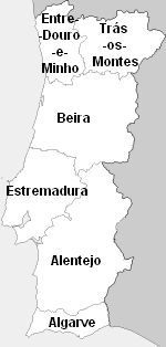
intermunicipal communities: Alentejo Central Alentejo Litoral Algarve Alto Alentejo Alto Minho Alto Tâmega Ave Baixo Alentejo Beira Baixa Beiras e Serra da Estrela...
42 KB (3,947 words) - 11:06, 16 January 2025

projects in Spain include: Tâmega hydroelectric complex – three new power plants: Gouvães, Daivões and Alto Tâmega on the Tâmega river, with a total installed...
130 KB (13,974 words) - 14:58, 28 March 2025

Districts (entirely or partly included) Norte Alto Minho Cávado Ave Porto Douro Tâmega e Sousa Alto Tâmega Trás-os-Montes Viana do Castelo, Braga, Porto...
11 KB (375 words) - 16:35, 3 January 2025

communities are: Alentejo Central Alentejo Litoral Algarve Alto Alentejo Alto Minho Alto Tâmega Ave Baixo Alentejo Beira Baixa Beiras e Serra da Estrela...
4 KB (273 words) - 11:35, 2 November 2024

Douro (to the south), Tâmega Subregion (in the southwest), Ave (in the southwest) and Cávado (in the west). The NUTS III region of Alto Trás-os-Montes includes...
11 KB (920 words) - 05:47, 9 August 2024

Santo André to the urban area of Porto. Alto Minho Alto Tâmega Ave Cávado Douro Porto Metropolitan Area Tâmega e Sousa Terras de Trás-os-Montes Politically...
22 KB (1,927 words) - 13:17, 2 February 2025

bordered to the north by Cávado, to the east by Alto Tâmega, to the southeast by Douro, to the south by Tâmega e Sousa and the southwest by the Metropolitan...
4 KB (240 words) - 05:47, 9 August 2024

community of Ave and the Metropolitan Area of Porto to the south, Alto Tâmega to the east, Alto Minho to the north and the Atlantic Ocean to the west. It is...
4 KB (240 words) - 11:16, 18 November 2024

July 2014 for the design, construction and operation of three projects: Alto Tâmega, Daivões and Gouvães dams. Construction of the dam completed in July...
5 KB (272 words) - 18:55, 26 November 2024

da Barca Ponte de Lima Valença Viana do Castelo Vila Nova de Cerveira Alto Tâmega [6 municipalities] Vila Real District [6] Boticas Chaves Montalegre Ribeira...
18 KB (1,816 words) - 01:41, 3 September 2024

Continental PT11 Norte PT111 Alto Minho PT112 Cávado PT119 Ave PT11A Área Metropolitana do Porto PT11B Alto Tâmega PT11C Tâmega e Sousa PT11D Douro PT11E...
12 KB (688 words) - 00:20, 9 March 2025
Trás-os-Montes 1,998,568,000 0.7% 18,632 73.7% 25 Alto Alentejo 1,991,348,000 0.7% 19,112 75.6% 26 Alto Tâmega 1,385,256,000 0.5% 16,572 65.6% Portugal 267...
7 KB (80 words) - 12:32, 14 January 2025
57°W / 41.65; -7.57 Country Portugal Region Norte Intermunic. comm. Alto Tâmega District Vila Real Municipality Chaves Area • Total 6.4 km2 (2.5 sq mi)...
3 KB (364 words) - 00:05, 1 May 2023

41.82306; -7.79167 Country Portugal Region Norte Intermunic. comm. Alto Tâmega District Vila Real Seat Montalegre Municipal Chamber Parishes 27 (see...
14 KB (782 words) - 16:32, 9 April 2025
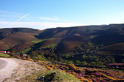
Pastoria. It is part of the group of municipalities referred to as the Alto Tâmega, integrated into the legendary "Region of the Barroso", that is constituted...
14 KB (1,565 words) - 12:10, 12 April 2025

Tavares [2] Archived June 19, 2013, at the Wayback Machine Diário do Alto Tâmega e Barroso, João Soares Tavares (in Portuguese) Afonso, Paulo (December...
38 KB (4,070 words) - 18:47, 7 April 2025
population in 2011 was 262, in an area of 29.58 km2. Located in the subregion of Alto Trás-os-Montes, it comprises three villages: Covas do Barroso, Romaínho and...
6 KB (555 words) - 20:17, 1 November 2024

market square, municipal slaughterhouse and well. Integrated into the Alto Tâmega subregion, the municipality of Vila Pouca de Aguiar is situated in the...
13 KB (1,262 words) - 12:04, 29 December 2024
734°W / 41.623; -7.734 Country Portugal Region Norte Intermunic. comm. Alto Tâmega District Vila Real Municipality Ribeira de Pena Area • Total 36.16 km2...
2 KB (65 words) - 10:27, 9 August 2024
Ribeira de Pena (Salvador) e Santo Aleixo de Além-Tâmega is a civil parish in the municipality of Ribeira de Pena, Portugal. It was formed in 2013 by the...
2 KB (98 words) - 06:59, 21 September 2022

950°W / 41.841; -7.950 Country Portugal Region Norte Intermunic. comm. Alto Tâmega District Vila Real Municipality Montalegre Area • Total 36.89 km2 (14...
3 KB (174 words) - 22:19, 18 April 2024

705°W / 41.849; -7.705 Country Portugal Region Norte Intermunic. comm. Alto Tâmega District Vila Real Municipality Montalegre Area • Total 21.59 km2 (8...
2 KB (85 words) - 00:10, 17 June 2024
July 2014 for the design, construction and operation of three projects: Alto Tâmega, Daivões and Gouvães dams. Construction of the dam completed in July...
5 KB (287 words) - 18:55, 26 November 2024

/ 41.8929; -7.9539 Country Portugal Region Norte Intermunic. comm. Alto Tâmega District Vila Real Municipality Montalegre Area • Total 16.61 km2 (6...
2 KB (103 words) - 15:36, 1 December 2023
470°W / 41.758; -7.470 Country Portugal Region Norte Intermunic. comm. Alto Tâmega District Vila Real Municipality Chaves Area • Total 13.38 km2 (5.17 sq mi)...
2 KB (150 words) - 18:58, 2 November 2024