is a list of secondary highways in Kenora District, most of which provide access to isolated and sparsely populated areas in the Kenora District of northwestern...
30 KB (2,153 words) - 02:37, 7 July 2023

Kenora District is a district and census division in Northwestern Ontario, Canada. The district seat is the City of Kenora. It is geographically the largest...
19 KB (1,056 words) - 21:32, 29 March 2024

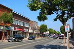
(130 mi) east of Winnipeg by road. It is the seat of Kenora District. The history of the name extends beyond the time of French settlers arriving in the region...
47 KB (3,936 words) - 03:10, 12 June 2024

in Kenora District. The highway extends 25.3 kilometres (15.7 mi) between the city of Kenora and the community of Redditt. For a decade, Highway 658...
6 KB (471 words) - 17:02, 20 June 2024
This is a list of secondary highways in Cochrane District, most of which serve as logging roads, mine and dam access roads, or provide access to isolated...
18 KB (1,354 words) - 10:20, 11 August 2022
This is a list of secondary highways in Thunder Bay District, most of which serve as logging roads or provide access to the isolated and sparsely populated...
30 KB (1,905 words) - 15:53, 3 September 2023
This is a list of secondary highways in Manitoulin District, which serve the isolated and sparsely populated areas in the Manitoulin District of Ontario...
11 KB (764 words) - 00:18, 19 June 2024
is a list of secondary highways in Rainy River District, most of which serve isolated and sparsely populated areas in the Rainy River District of northwestern...
8 KB (525 words) - 15:52, 3 September 2023
This is a list of secondary highways in Timiskaming District, most of which serve as logging roads or provide access to the isolated and sparsely populated...
17 KB (982 words) - 16:49, 10 April 2023
a list of secondary highways in Sudbury District, most of which serve as logging roads or provide access to provincial parks and isolated areas in the...
7 KB (491 words) - 20:51, 31 March 2022
a list of secondary highways in Algoma District, most of which serve as logging roads or provide access to isolated and sparsely populated areas in the...
35 KB (2,703 words) - 03:04, 20 June 2024
This is a list of secondary highways in Parry Sound District, many of which provide access to isolated settlements and recreational properties within...
25 KB (1,585 words) - 21:30, 1 September 2022
This is a list of secondary highways in Nipissing District, many of which serve as logging roads or provide access to Algonquin Park and sparsely populated...
13 KB (782 words) - 22:20, 31 March 2021
2018. "Provincial Highways Assumed in 1922". Annual Report (Report). Department of Public Highways. 1922. p. 31. "Highway 17A in Kenora". Hansard Transcripts...
118 KB (2,499 words) - 00:21, 19 June 2024

point, Highway 11 continues west while Highway 71 branches north and travels 154 kilometres (96 mi) to a junction with Highway 17 just east of Kenora. Highway 71...
23 KB (2,106 words) - 01:09, 25 June 2024
province of Ontario. It begins at the Manitoba boundary, 50 km (31 mi) west of Kenora, and the main section ends where Highway 417 begins just west of Arnprior...
89 KB (6,792 words) - 16:28, 20 June 2024

technically part of the Trans-Canada Highway, they are usually considered either secondary routes or different highways altogether. For example, Highway 16 throughout...
69 KB (8,114 words) - 21:01, 12 June 2024

of Highways to improve connections between King's Highways. The highway followed the route of present-day Muskoka District Road 18 north from Highway 11...
6 KB (610 words) - 20:25, 12 May 2021

road in Northwestern Ontario that travels generally southwest–northeast through the dense forests, lakes and hills of Thunder Bay and Kenora District. It...
12 KB (1,084 words) - 18:35, 15 March 2024
modern road in the 1920s. Highway 70 was designated in 1965 and renumbered as Highway 6 in 1997. Another Highway 70 existed near Kenora between 1937...
13 KB (1,430 words) - 09:05, 1 August 2023
King's Highway 17A, commonly referred to as Highway 17A or as the Kenora By-Pass, is an alternate route of Highway 17 around the city of Kenora, in the Canadian...
7 KB (479 words) - 01:52, 9 December 2023
as part of the King's Highway, secondary highways, and tertiary roads. Components of the system—comprising 16,900 kilometres (10,500 mi) of roads and...
119 KB (11,363 words) - 08:06, 29 May 2024
Kenora District of northern Ontario, the highway extends for 173.5 kilometres (107.8 mi) from an intersection with Highway 17 between Kenora and Dryden...
15 KB (1,461 words) - 16:41, 15 May 2024

Northern Ontario (redirect from Sports in Northern Ontario)
districts have provincially maintained secondary highways instead of county roads. Statistically, the districts in Northern Ontario (which appear in red...
62 KB (6,520 words) - 21:57, 12 June 2024
Shabaqua Corners, where the two highways split; Highway 17 continues northwest to Dryden and Kenora, while Highway 11 continues in a generally west direction...
131 KB (9,529 words) - 22:24, 9 June 2024

The districts of Ontario, each followed by its district seat: Algoma District (Sault Ste. Marie) Cochrane District (Cochrane) Kenora District (Kenora) Manitoulin...
65 KB (1,758 words) - 17:34, 23 May 2024
6 mi), the entirety of which is situated in Kenora District. There are no significant settlements between its endpoints. Highway 72 is a 68.5 km (42.6 mi)...
7 KB (679 words) - 03:54, 14 November 2021
Fort Frances (redirect from Coat of Arms of Fort Frances, Ontario)
community in Northwestern Ontario after Thunder Bay, Kenora and Dryden. The Fort Frances Paper Mill was formerly the main employer and industry in the town...
26 KB (2,152 words) - 00:55, 21 June 2024

formerly used the airport for glider operations in the spring and fall. Eabametoong First Nation, Kenora District, Ontario, Canada (January 1, 2017) Source:...
92 KB (7,568 words) - 18:37, 16 June 2024
Ontario (redirect from Transport in Ontario)
on a road from the Trans-Canada Highway near Kenora to the deposit, currently valued at CAD$60 billion. An abundance of natural resources, excellent transportation...
163 KB (13,511 words) - 20:12, 29 June 2024