
Petén (from the itz'a, Noj Petén, 'Great Island') is a department of Guatemala. It is geographically the northernmost department of Guatemala, as well...
19 KB (1,401 words) - 03:57, 2 January 2025
department of El Petén in Guatemala. The municipality is formed by the town of San Andrés, located on the north-western shore of Lake Petén Itzá, and 55 rural...
6 KB (134 words) - 08:30, 14 April 2024
Poptún (category Municipalities of the Petén Department)
(PDF) on 26 November 2011. Retrieved 29 June 2015. "Municipios del Departamento de El Petén". SEGEPLAN (in Spanish). Guatemala. Archived from the original...
3 KB (146 words) - 06:59, 21 October 2024
8. Collectif 2011, p. 9. SEGEPLAN. "Municipios del departamento de El Petén". Secretaría General de Planificación (in Spanish). Guatemala. Archived from...
9 KB (725 words) - 04:10, 15 August 2024

Maya civilization (section Central Petén)
The Petén region consists of densely forested low-lying limestone plain; a chain of fourteen lakes runs across the central drainage basin of Petén. To...
187 KB (22,910 words) - 13:13, 27 December 2024

Sayaxché (category Municipalities of the Petén Department)
Municipio de Sayaxché, departamento de Petén (PDF) (in Spanish). Guatemala: Facultad de Ciencias Económicas de la Universidad de San Carlos de Guatemala...
12 KB (755 words) - 08:04, 28 December 2024

Regional del Sureste de Petén ("Southeastern Petén Regional Museum") is an archaeological museum in the town of Dolores in the Petén Department of Guatemala...
14 KB (1,270 words) - 15:17, 9 October 2024

mountainous, except for the south coastal area and the vast northern lowlands of Petén department. The country is located in Central America and bounded to the...
16 KB (1,224 words) - 01:28, 23 June 2024

fourteen lakes runs across the central drainage basin of Petén. The largest lake is Lake Petén Itza; it measures 32 by 5 kilometres (19.9 by 3.1 mi). A...
169 KB (21,592 words) - 08:32, 31 December 2024
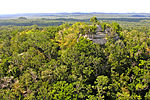
El Mirador (category Maya sites in Petén Department)
AD) Maya settlement, located in the north of the modern department of El Petén, Guatemala. It is part of the Mirador-Calakmul Karst Basin of northern Guatemala...
26 KB (3,102 words) - 22:48, 12 September 2024

calendario de esta antigua civilización (in Spanish) Departamento de Historia de América II (Antropología de América) (in Spanish) Hoy, 9 de Febrero de 2018...
4 KB (305 words) - 19:24, 12 November 2024

the central highlands and the mountain ranges of the Sierra de los Cuchumatanes, Sierra de Chuacús, and the foothills of the volcanic mountain range on...
13 KB (795 words) - 08:08, 18 September 2024

New Spain (redirect from Virreinato de la Nueva España)
organization, the Consulado de Comercio. There were regions that were not subjugated to Spanish rule, such as the Petén and the Mosquito Coast, and the...
112 KB (13,554 words) - 04:05, 31 December 2024
Spanish conquest of Guatemala (section Cortés in Petén)
and their Petén Neighbors". In Prudence M. Rice; Don S. Rice (eds.). The Kowoj: identity, migration, and geopolitics in late postclassic Petén, Guatemala...
145 KB (17,045 words) - 00:08, 18 August 2024
elite lineages. In the southern Yucatán and central Petén, kingdoms generally declined; in western Petén and some other areas, the changes were catastrophic...
60 KB (7,260 words) - 13:43, 3 December 2024

Holtun (category Maya sites in Petén Department)
a Maya archaeological site located in the Petén Department of northern Guatemala on the road to Melchor de Mencos from Flores. The city had a long period...
25 KB (3,353 words) - 02:59, 15 August 2024

city of the department is Cobán. Verapaz is bordered to the north by El Petén, to the east by Izabal, to the south by Zacapa, El Progreso, and Baja Verapaz...
9 KB (507 words) - 23:33, 12 August 2024
Guatemala (redirect from República de Guatemala)
and the Petén region, north of the mountains. All major cities are located in the highlands and Pacific coast regions; by comparison, Petén is sparsely...
199 KB (19,728 words) - 15:25, 20 December 2024

governmental decree on 8 May 1866, together with Huehuetenango, Izabal and Petén departments. In 1902 the eruption of the Santa María volcano in the neighbouring...
23 KB (1,638 words) - 09:53, 5 December 2024

departments of Petén to the northwest, Alta Verapaz to the west, and Zacapa to the south. The Izabal Department surrounds Lake Izabal (or Lago de Izabal), which...
8 KB (362 words) - 23:44, 12 August 2024

By 1528, the conquest of Guatemala was nearly complete, with only the Petén Basin remaining outside the Spanish sphere of influence. The last independent...
106 KB (7,892 words) - 04:48, 11 December 2024
1000 AD, most of the major Classic-era (250–900 AD) Maya cities in the Petén Basin, located in the northern lowlands, had been abandoned. The Maya states...
252 KB (30,358 words) - 04:26, 2 December 2024

Yucatán (redirect from Estado Libre y Soberano de Yucatán)
the Palms). The first Maya moved to the Peninsula circa 250 CE, from the Petén (today northern Guatemala), to settle the southeastern peninsula in the...
62 KB (5,377 words) - 04:02, 26 December 2024

2 de abril de 1930. El libro de Guatemala grande: Petén-Belice. Guatemala: Tipografía nacional. 1947. Los dos brujitos mayas: el cuento-novela de la...
5 KB (501 words) - 21:07, 10 September 2024

resolved. ISO 3166-2:GT "Republica de Guatemala Departamentos de Guatemala". Servicio de Información Municipal de Inforpress. Archived from the original...
15 KB (252 words) - 08:11, 1 September 2024

the Caribbean coast and the route from Copán to the major cities of the Petén Basin. As recorded on hieroglyphic inscriptions at Quiriguá, all dates are...
67 KB (8,510 words) - 02:53, 28 October 2024

Perú), also known as the Protectorate of San Martín (Spanish: Protectorado de San Martín), was a protectorate created in 1821 in present-day Peru after...
18 KB (1,929 words) - 16:33, 2 November 2024

El Zotz (category Maya sites in Petén Department)
archaeological site of the pre-Columbian Maya civilization, located in the Petén Basin region around 20 kilometres (12 mi) west of the major center of Tikal...
29 KB (3,921 words) - 06:28, 15 August 2024

Rivera (2013). "Determinación De La Subzonificacion De La Reserva De La Biosfera Sierra De Manantlan". Departamento de Ecología y Recursos Naturales-IMECBIO...
101 KB (6,285 words) - 12:34, 30 October 2024

Efraín Ríos Montt (section De facto presidency)
Montt's presidency. The first was in Plan de Sánchez, in Baja Verapaz, with 268 dead, and in Dos Erres in Petén, where 200 people were murdered.[citation...
77 KB (8,633 words) - 10:02, 6 November 2024