
Chibougamau (French pronunciation: [ʃibuɡamo]) is the largest town in Nord-du-Québec, central Québec, Canada. Located on Lake Gilman, it has a population...
20 KB (1,187 words) - 10:56, 22 August 2024

Chibougamau Lake is a freshwater body of the municipality of Chibougamau, in the administrative region of Nord-du-Québec, in province of Quebec, in Canada...
8 KB (1,014 words) - 10:02, 13 June 2024

exception of the Cree Category 1 lands and the enclaves of Chapais, Chibougamau, Lebel-sur-Quévillon and Matagami. In December 2001, the municipal council...
22 KB (1,384 words) - 18:56, 5 September 2024

The Barlow River is a tributary of the Chibougamau River, flowing into the Regional County Municipality (RCM) of Eeyou Istchee Baie-James, Jamésie, in...
9 KB (1,026 words) - 11:53, 26 September 2023
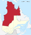
population of 12,090. The most populous community overall is the town of Chibougamau in Jamésie. The most populous community in Eeyou Istchee is Chisasibi...
31 KB (1,624 words) - 07:31, 30 August 2024
Chibougamau/Chapais Airport (IATA: YMT, ICAO: CYMT) is located 10.7 nautical miles (19.8 km; 12.3 mi) southwest of Chibougamau, Quebec, Canada, or about...
3 KB (142 words) - 17:36, 30 January 2024
Chibougamau/Lac Caché Water Aerodrome, formerly TC LID: CSZ7, was located on Lac Caché, 6 nautical miles (11 km; 6.9 mi) south southwest of Chibougamau...
2 KB (84 words) - 03:13, 28 January 2023
Blondeau River is a tributary of Chibougamau Lake (via McKenzie Bay), flowing entirely into the town of Chibougamau, in Jamésie, in the administrative...
7 KB (772 words) - 11:16, 16 October 2023

airport. It is 768 km (477 mi) northwest of Chibougamau via the Route du Nord and the James Bay Road. (Chibougamau is 700 km (430 mi) by road north of Montreal)...
113 KB (10,661 words) - 19:15, 2 September 2024
The Chibougamau River flows west in the Chibougamau, then Eeyou Istchee James Bay (municipality) in the administrative region of Nord-du-Québec, Quebec...
7 KB (616 words) - 03:13, 28 January 2023
The Nepton River is a tributary of Chibougamau Lake, flowing into the Municipality of Eeyou Istchee James Bay, in Jamésie, in the administrative region...
8 KB (911 words) - 04:44, 5 December 2023
Dorés Lake (redirect from Dorés Lake (Chibougamau River))
aux Dorés (English: Dorés Lake) is a freshwater body in the city of Chibougamau, in Jamésie, in the administrative region of Nord-du-Québec, in the province...
6 KB (734 words) - 03:17, 28 January 2023
The Brock River is a tributary of the Chibougamau River, flowing in Eeyou Istchee Baie-James, in the administrative region of Nord-du-Québec, in the province...
10 KB (1,116 words) - 11:11, 28 October 2023
River (Chibougamau River), Chibougamau River, Brock River North, Chibougamau Lake, Barlow River; South side: Opémisca Lake, Opémisca River, Chibougamau River;...
8 KB (856 words) - 11:11, 28 October 2023
is accessible through the road 113 which link Lebel-sur-Quevillon to Chibougamau. The surface of Lake Caupichigau is usually frozen from early November...
4 KB (546 words) - 03:11, 28 January 2023
CFS Chibougamau CFS Chibougamau, or RCAF Station Chibougamau (pre-1967), housed the 10 Radar Squadron (Royal Canadian Air Force). The facility was a military...
3 KB (223 words) - 03:09, 28 January 2023
connecting to the north at route 113 (linking Lebel-sur-Quévillon and Chibougamau) and the Canadian National Railway. The surface of Lake Chevrier is usually...
5 KB (600 words) - 03:13, 28 January 2023
The Mistago River is a tributary of the Barlow River (Chibougamau River), flowing into the Regional County Municipality (MRC) of Eeyou Istchee Baie-James...
7 KB (682 words) - 10:48, 31 May 2024

connecting to the north at route 113 (linking Lebel-sur-Quévillon and Chibougamau) and the Canadian National Railway. Haüy Township is located north of...
5 KB (668 words) - 05:31, 28 January 2023

slightly larger than Ecuador) and a 2016 population of 13,941 inhabitants. Chibougamau is the largest community in both Jamésie TE and Nord-du-Québec. The original...
5 KB (359 words) - 17:55, 5 June 2023
Michwacho Lake is a freshwater body crossed by the Chibougamau River, in the southern part of Eeyou Istchee James Bay (municipality), in the administrative...
4 KB (518 words) - 05:29, 28 January 2023
The Chebistuane River is a tributary of the Barlow River (Chibougamau River), flowing into the Regional County Municipality (RCM) of Eeyou Istchee Baie-James...
7 KB (765 words) - 04:56, 29 March 2023
Chevrillon Lake is a freshwater body crossed by the Chibougamau River, in the southern part of Eeyou Istchee James Bay (municipality), in the administrative...
4 KB (533 words) - 17:59, 15 July 2024
Brock River (Chibougamau River), Chibougamau River, Mistassini Lake, Chibougamau Lake, Barlow River; South side: Brock River (Chibougamau River), Opémisca...
9 KB (1,008 words) - 11:11, 28 October 2023
of the South Island of New Zealand Barlow River (Chibougamau River), a tributary of the Chibougamau River in Quebec, Canada This disambiguation page lists...
273 bytes (71 words) - 13:01, 27 December 2017
mid-November to mid-April. Lake Opemisca is fed on the east side by the Chibougamau River which crosses the "Rapides Entre les Îles" where a bridge is laid...
7 KB (1,009 words) - 06:01, 17 January 2024
River is a tributary of the Blondeau River (Chibougamau Lake), flowing entirely in the town of Chibougamau, in Jamésie, in the administrative region of...
8 KB (859 words) - 04:44, 5 December 2023
The Armitage River is a tributary of Chibougamau Lake, flowing in the town of Chibougamau, in Jamésie, in the administrative region of Nord-du-Québec,...
9 KB (1,033 words) - 18:49, 8 September 2023
Côte-de-Beaupré Capitale-Nationale Québec 4,126 3,834 7.6 229.55 88.63 18.0 47 Chibougamau Nord-du-Québec 7,504 7,541 −0.5 698.13 269.55 10.7 28 Clermont Charlevoix-Est...
77 KB (182 words) - 12:02, 3 August 2024
The Faribault River is a tributary of the east bank of the Chibougamau River flowing into Eeyou Istchee Baie-James (municipality), in Jamésie, in the...
8 KB (870 words) - 22:40, 1 February 2022