Geological structure measurement by LiDAR technology is a remote sensing method applied in structural geology. It enables monitoring and characterisation...
53 KB (5,217 words) - 04:14, 24 June 2024

Lidar (/ˈlaɪdɑːr/, also LIDAR, LiDAR or LADAR, an acronym of "light detection and ranging" or "laser imaging, detection, and ranging") is a method for...
130 KB (14,772 words) - 00:21, 24 September 2024

different specialized magnetic compasses used by geologists to measure orientation of geological structures, as they map in the field, to analyze and document...
8 KB (1,020 words) - 23:14, 19 April 2024
used in the geological sciences as a data acquisition method complementary to field observation, because it allows mapping of geological characteristics...
62 KB (7,081 words) - 03:56, 24 June 2024

surface structure. Areal roughness parameters are defined in the ISO 25178 series. The resulting values are Sa, Sq, Sz,... Many optical measurement instruments...
35 KB (3,727 words) - 14:25, 29 August 2024

Underwater exploration (section Direct measurements)
investigation of the geological characteristics of the seabed and freshwater equivalents, and investigation of the geological structure, strata, and sediments...
38 KB (4,737 words) - 19:27, 22 July 2024

Photogrammetry (category Articles covered by WikiProject Wikify from June 2019)
z direction [citation needed]. This range data can be supplied by techniques like LiDAR, laser scanners (using time of flight, triangulation or interferometry)...
31 KB (3,249 words) - 19:12, 6 August 2024

planetary body has a unique reference surface. Lidar Radar Stereo photogrammetry from aerial surveys Structure from motion / Multi-view stereo applied to...
30 KB (3,235 words) - 10:40, 4 July 2024

stereoplotter has been replaced by more modern photogrammetric methods, digital and automated, as in the case of structure from motion. Lidar (light radar) has also...
9 KB (1,351 words) - 20:49, 16 February 2021
EarthScope (category Regional geology)
Foundation (NSF) funded Earth science program using geological and geophysical techniques to explore the structure and evolution of the North American continent...
34 KB (4,457 words) - 19:57, 5 October 2024

Dataset (PDF). U.S. Geological Survey. 2009. Maceyka, Andy; Hansen, William F (2016). "Enhancing hydrologic mapping using LIDAR and high resolution aerial...
30 KB (3,165 words) - 05:31, 6 May 2024

Subsidence (category Depressions (geology))
Satellite System (GNSS) Interferometric Synthetic Apertura Radar (InSAR) LiDAR Tiltmeters. Tomás et al. conducted a comparative analysis of various land...
53 KB (5,499 words) - 00:16, 3 September 2024

Precipitation (redirect from Precipitation measurement)
centimeters by letting snow fall into a container and then measure the height. The snow can then optionally be melted to obtain a water equivalent measurement in...
88 KB (9,402 words) - 17:37, 20 September 2024

Underwater survey (section Geological surveys)
looking over and detailed study of a subject. One meaning is the accurate measurement of a geographical region, usually with the intention of plotting the...
32 KB (4,066 words) - 04:50, 20 July 2024

Digital outcrop model (category Geological techniques)
for interpretation and reproducible measurement of different geological features, e.g. orientation of geological surfaces, width and thickness of layers...
16 KB (1,888 words) - 14:30, 9 March 2024

Carolina bays (category Geology of the United States)
Plain Uplands of North and South Carolina Revealed by High-Resolution LiDAR Data. PDF version Geological Society of America Abstracts with Programs. v. 43...
42 KB (5,249 words) - 05:05, 16 July 2024

concurrent deployment of both a polarimeter and Lidar instrument from an airplane (airborne measurements). The survey recommended intentional, early development...
20 KB (1,999 words) - 11:46, 13 January 2024

Spectroradiometry for Earth and planetary remote sensing (category Geological techniques)
volcanic materials from hyperspectral field and satellite data compared with LiDAR data at Mt. Etna". International Journal of Applied Earth Observation and...
71 KB (6,336 words) - 21:33, 22 September 2024
particle sensor, electromagnetic & sonic wave measurement of dust, and short range LIDAR. Geology Geological description of the landing site including interior...
11 KB (728 words) - 12:04, 1 June 2024

sensors attached to a platform. Sensors include cameras, digital scanners and lidar, while platforms usually consist of aircraft and satellites. In England...
101 KB (13,118 words) - 10:22, 14 September 2024
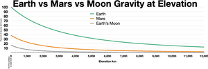
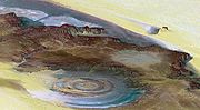
Gravity of Mars (section Measurement)
be further assisted by employment of LIDAR on site in determining the exact landing position and other protective measures. Geology of Mars Mars carbonate...
53 KB (6,283 words) - 10:38, 6 October 2024

Tiwanaku (category Buildings and structures in La Paz Department (Bolivia))
decorated ceramics, monumental structures, and megalithic blocks. It has been conservatively estimated that the site was inhabited by 10,000 to 20,000 people...
43 KB (4,958 words) - 22:35, 28 September 2024

Radar (redirect from Radar distance measurement)
make use of other parts of the electromagnetic spectrum. One example is lidar, which uses predominantly infrared light from lasers rather than radio waves...
99 KB (11,852 words) - 10:45, 21 September 2024

active remote sensing instruments: Lidar: Lidar (light detection and ranging) uses a laser (light amplification by stimulated emission of radiation) to...
135 KB (14,003 words) - 02:02, 28 September 2024
January–March 2012 in science (category Science timelines by year)
airborne LIDAR system, scientists produce the most detailed 3D image of the Amazon rainforest yet recorded, allowing the accurate measurement of the rainforest's...
103 KB (10,240 words) - 20:17, 25 August 2024

Sea level rise (redirect from Measurement of sea levels)
under warming of 3 °C (5.4 °F). This is close to the current trajectory. LiDAR-based research had established in 2021 that 267 million people worldwide...
207 KB (21,870 words) - 11:16, 24 September 2024


local people were aware of this cave for centuries. According to a GPS measurement in 2008, its altitude is 539 metres (1,768 ft) above sea level. Located...
20 KB (2,582 words) - 09:09, 2 October 2024
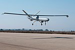
Unmanned aerial vehicle (section Geological hazards)
as: RGB, multispectral, hyper-spectral cameras or LiDAR, which may allow providing specific measurements or observations. UAV actuators include digital electronic...
150 KB (14,015 words) - 00:34, 5 October 2024

measures is demonstrated by the use of precise measurement for gold, and familiarity with rudimentary astronomy is shown by fixing the precise day within...
94 KB (11,415 words) - 00:47, 2 October 2024