Department of Transport and Main Roads, and about the state-controlled roads that intersect with it. The Bruce Highway runs from Bald Hills to Cairns in...
40 KB (3,348 words) - 15:45, 4 April 2024
Department of Transport and Main Roads, and about the state-controlled roads that intersect with it. The Warrego Highway runs from Ipswich to Charleville...
23 KB (1,932 words) - 00:40, 22 January 2024
Department of Transport and Main Roads, and about the state-controlled roads that intersect with it. The Cunningham Highway runs from Goodna to Goondiwindi...
22 KB (1,802 words) - 22:38, 9 February 2024

The Bruce Highway is a major highway in Queensland, Australia. Commencing in the state capital, Brisbane, it passes through areas close to the eastern...
103 KB (5,393 words) - 07:55, 6 August 2024

Gavial–Gracemere Road is a state-controlled district road (number 450). It runs from the Bruce Highway in Midgee to the Capricorn Highway in Gracemere, a...
15 KB (926 words) - 06:03, 27 April 2024
Marlborough–Sarina Road is a state-controlled district road (number 512) rated as a local road of regional significance (LRRS). It runs from the Bruce Highway in Marlborough...
18 KB (1,471 words) - 05:56, 19 December 2023
Department of Transport and Main Roads, and about the state-controlled roads that intersect with it. The Mount Lindesay Highway runs from Drewvale to Mount...
6 KB (516 words) - 02:20, 5 March 2024
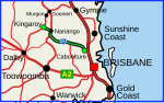
The D'Aguilar Highway is a two-lane highway linking the Bruce Highway near Caboolture with the Bunya Highway in Kingaroy in the state of Queensland, Australia...
22 KB (1,111 words) - 16:52, 25 July 2024
Transport and Main Roads, and about the state-controlled roads that intersect with it. The Queensland segment of the New England Highway runs from Yarraman...
12 KB (1,052 words) - 01:05, 22 January 2024

Bay Highway is a short state highway of Queensland, Australia running between Goomeri on the Burnett Highway and a junction on the Bruce Highway. From...
9 KB (642 words) - 21:06, 25 July 2024

addition to the Bruce, Leichhardt, Gregory and Landsborough Highways, and the Fitzroy Developmental Road, the following state-controlled roads, from east to...
18 KB (1,318 words) - 20:53, 18 May 2024
state-controlled district road (number 837). It runs from Bruce Highway exit and entry ramps in Douglas to the Douglas–Garbutt Road (University Road)...
29 KB (2,361 words) - 18:21, 25 July 2024
Connection Road is a state-controlled district road (number 1411) rated as a local road of regional significance (LRRS). It runs from the Bruce Highway in Gympie...
14 KB (1,173 words) - 03:15, 17 August 2024
Maryland highway system has several hundred former state highways. These highways were constructed, maintained, or funded by the Maryland State Roads Commission...
104 KB (12,452 words) - 18:24, 21 August 2023
Cook Highway, Cairns Western Arterial Road, and the Kennedy Highway, the network consists of the following state-controlled roads: Mulgrave Road Port...
6 KB (528 words) - 21:15, 5 April 2024
district road (number 914). Known as Old Bruce Highway, It runs from Cooroy Connection Road on the Black Mountain / Pomona midpoint to the Bruce Highway in...
10 KB (693 words) - 01:31, 31 October 2023

the Bruce, Burnett, Leichhardt, Carnarvon and Gregory Highways, and the Fitzroy and Dawson Developmental Roads, the following state-controlled roads, from...
20 KB (1,301 words) - 20:52, 28 July 2024
following state-controlled roads intersect with this road: Eumundi–Kenilworth Road Emu Mountain Road Eumundi–Kenilworth Road is a state-controlled district...
13 KB (1,026 words) - 16:59, 25 July 2024
Wallaville, this road was part of the Bruce Highway. This road intersects with the following state-controlled roads: Isis Highway Moore Park Road Bundaberg–Miriam...
13 KB (1,025 words) - 16:41, 25 July 2024
This road intersects with the following state-controlled roads: Homebush Road Peak Downs Highway Mirani–Eton Road North Eton Road Mackay–Eungella Road Homebush...
13 KB (1,015 words) - 03:46, 17 August 2024

Highways in Australia are generally high capacity roads managed by state and territory government agencies, though Australia's federal government contributes...
49 KB (4,938 words) - 12:17, 8 August 2024
Bli Bli before reaching the Bruce Highway, which it passes under at a dumbbell intersection. It runs southeast as State Route 10, and then northeast...
11 KB (732 words) - 23:27, 8 May 2024
is signed as 'State Route 6' and is a state-controlled district road (number 142) for most of its length. The road, known locally as Diamond Street, starts...
10 KB (771 words) - 13:50, 12 August 2024

Westwood. The highway is a state-controlled strategic road, except for the section concurrent with the Gore Highway, which is a state-controlled part of the...
9 KB (266 words) - 22:59, 27 May 2024
Maryland highway system has several hundred former state highways. These highways were constructed, maintained, or funded by the Maryland State Roads Commission...
72 KB (8,399 words) - 01:10, 30 October 2023

Roads, the following state-controlled roads, from east to west, intersect with the Flinders Highway: Townsville Port Road Townsville Connection Road Woodstock–Giru...
19 KB (1,271 words) - 00:30, 5 May 2024
Childers is a state-controlled regional road (number 19A) while that between Childers and Ban Ban Springs is a state-controlled strategic road (numbers 19B...
9 KB (660 words) - 09:31, 26 August 2024

Highways and main roads in the Wheatbelt region of Western Australia form the basis of a road network, which is primarily used by the mining, agriculture...
44 KB (2,660 words) - 02:22, 11 May 2024
of the following state-controlled roads: Brighton–Redcliffe Road (see below for component bridges and roads) Clontarf–Anzac Avenue Road (Elizabeth Avenue...
13 KB (1,137 words) - 17:59, 25 July 2024
state highways in Maryland shorter than one mile (1.6 km) in length with route numbers between 2 and 699. Most of these highways act as service roads...
89 KB (7,784 words) - 21:37, 4 May 2024