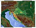
The geography of Croatia is defined by its location—it is described as located at the crossroads of Central Europe and Southeast Europe, a part of the...
100 KB (10,197 words) - 20:26, 12 June 2024

Croatia (/kroʊˈeɪʃə/ , kroh-AY-shə; Croatian: Hrvatska, pronounced [xř̩ʋaːtskaː]), officially the Republic of Croatia (Croatian: Republika Hrvatska listen)...
222 KB (20,521 words) - 13:59, 15 July 2024
At the time of the Roman Empire, the area of modern Croatia comprised two Roman provinces, Pannonia and Dalmatia. After the collapse of the Western Roman...
139 KB (15,540 words) - 12:59, 22 July 2024
In Croatia, the standard time is Central European Time (CET; UTC+01:00). Daylight saving time is observed from the last Sunday in March (02:00 CET) to...
3 KB (228 words) - 23:16, 10 June 2024
See ISO 3166-2:HR Internet country code top-level domain: .hr Geography of Croatia Croatia is: a country Location: Eastern Hemisphere Northern Hemisphere...
15 KB (930 words) - 13:08, 30 October 2023
This is a list of geographic names from ancient times in the current Republic of Croatia with modern names. Some of the current names refer to places that...
9 KB (149 words) - 21:24, 22 April 2024

Croatia's economic history is closely linked to its historic nation-building efforts. Its pre-industrial economy leveraged the country's geography and...
115 KB (8,416 words) - 08:41, 20 July 2024
in the list are ordered by height. Geography of Croatia List of rivers in Croatia List of lakes in Croatia Croatian Mountaineering Association For Dinara...
4 KB (249 words) - 18:08, 4 March 2022

borders of the Italian geographical region: in Croatia (partly included in the continental part and in the insular part, in the east): Istria, the city of Fiume...
27 KB (3,230 words) - 21:35, 22 April 2024
Topography of Croatia is defined through three major geomorphological parts of the country. Those are the Pannonian Basin, the Dinaric Alps, and the Adriatic...
17 KB (1,806 words) - 04:33, 13 May 2024
area in Croatia can gain the status of grad (which can be translated as town or city as there is no distinction between the two terms in Croatian) if it...
33 KB (1,555 words) - 07:27, 22 July 2024
of the Kingdom of Hungary and the Triune Kingdom of Croatia, Slavonia and Dalmatia". Though Dalmatia actually lay outside the Lands of the Crown of Saint...
34 KB (3,501 words) - 02:58, 14 July 2024

Republic of Croatia administratively consists of twenty counties, it is traditionally divided into four historical and cultural regions: Croatia proper...
6 KB (481 words) - 06:20, 15 July 2024

The demographic characteristics of the population of Croatia are known through censuses, normally conducted in ten-year intervals and analysed by various...
155 KB (8,221 words) - 06:04, 2 July 2024

Bora (wind) (category Geography of Croatia)
can often be felt all over Adriatic Croatia, Montenegrin Littoral, the Slovenian Littoral, Trieste, and the rest of the Adriatic east coast. It blows in...
13 KB (1,467 words) - 13:06, 16 May 2024
GPX (primary coordinates) GPX (secondary coordinates) The geographical extreme points of Croatia are Northernmost point: Sveti Martin na Muri (administratively...
2 KB (300 words) - 14:56, 30 January 2024
is a list of rivers in Croatia. Geography of Croatia "Geographical and meteorological data" (PDF). Statistical Yearbook. Croatian Bureau of Statistics...
6 KB (78 words) - 18:04, 16 February 2024
Civil Croatia (Croatian: Civilna Hrvatska) was a designation for the areas of Central Croatia that were not part of the Habsburg Military Frontier. It...
914 bytes (83 words) - 02:58, 14 July 2024
in Croatia, under the Slunj township, in Karlovac County. Register of spatial units of the State Geodetic Administration of the Republic of Croatia. Wikidata Q119585703...
1 KB (54 words) - 07:59, 24 September 2023
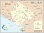
Mountain") is a small, mountainous country in Southeast Europe. It borders Croatia, Bosnia and Herzegovina, Serbia, Kosovo, Albania and the Adriatic Sea....
11 KB (1,007 words) - 14:00, 27 June 2024

provided as an overview of and topical guide to geography: Geography – study of Earth and its people. an academic discipline – a body of knowledge given to...
86 KB (7,707 words) - 19:24, 16 July 2024

Pannonian Steppe (redirect from Steppe of Pannonia)
and easternmost parts of Croatia. The Pannonian Steppe is an exclave of the Eurasian Steppe. The climate is continental. The part of the Pannonian Steppe...
6 KB (495 words) - 13:53, 18 April 2024
Settlements of Croatia". The Geography of Croatia. University of Zadar. p. 321. "Društva" [Societies]. shds.si (in Croatian). Alliance of Croatian Societies...
16 KB (1,732 words) - 22:01, 20 June 2024

Kvarner Gulf (redirect from Gulf of Kvarner)
many beaches and tourist locations because of its beautiful waters and warm climate. Geography of Croatia Italian: Golfo del Quarnaro or Carnaro; Latin:...
2 KB (204 words) - 09:07, 2 February 2024

The Croats (/ˈkroʊæts/; Croatian: Hrvati [xr̩ʋǎːti] or Horvati (in a more archaic version) are a South Slavic ethnic group native to Croatia, Bosnia and...
154 KB (15,470 words) - 15:07, 20 July 2024
in Croatia, under the Slunj township, in Karlovac County. Register of spatial units of the State Geodetic Administration of the Republic of Croatia. Wikidata Q119585703...
1 KB (54 words) - 08:02, 24 September 2023
in Croatia, under the Slunj township, in Karlovac County. Register of spatial units of the State Geodetic Administration of the Republic of Croatia. Wikidata Q119585703...
1 KB (54 words) - 07:56, 24 September 2023

The Independent State of Croatia (Serbo-Croatian: Nezavisna Država Hrvatska, NDH) was a World War II-era puppet state of Nazi Germany and Fascist Italy...
129 KB (14,868 words) - 09:10, 7 July 2024
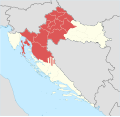
contemporary geography, the terms Central Croatia (Croatian: Središnja Hrvatska) and Mountainous Croatia (Gorska Hrvatska) are used to describe most of the area...
70 KB (6,392 words) - 16:17, 21 April 2024

Hrvatsko Zagorje (redirect from Croatian Highlands)
790 people) Klanjec (2,915 people) Geography of Croatia Zakarpattia and Záhorie (both contain similar geographic concepts) "Lonely Planet: Zagorje"....
4 KB (365 words) - 15:57, 15 April 2024