
Fault zone hydrogeology is the study of how brittlely deformed rocks alter fluid flows in different lithological settings, such as clastic, igneous and...
43 KB (4,111 words) - 15:34, 22 August 2024

balance; Fault zone hydrogeology: field specifically analyzing hydrogeology in fault zones Hydrogeophysics: field integrating hydrogeology with geophysics...
62 KB (8,006 words) - 06:35, 14 April 2025

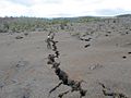
formed by localized zone of brittle deformation (a fault zone) in a rock. Brecciation in fault zones influences fault zone hydrogeology in its interaction...
3 KB (303 words) - 21:54, 25 November 2024
brittle deformation of rocks in fault zones; the mechanisms by which this occurs are the subject of fault zone hydrogeology. Permeability is also affected...
18 KB (1,931 words) - 03:02, 14 April 2025

stop the intrusion of seawater. Faults also affect the direction of water flow which is studied by Fault Zone Hydrogeology. Both regular and catastrophic...
45 KB (4,315 words) - 15:30, 19 January 2025

brittle deformation of rocks in fault zones; the mechanisms by which this occurs are the subject of fault zone hydrogeology. Reliance on groundwater will...
61 KB (7,991 words) - 03:54, 15 April 2025
Earthquake (section Fault types)
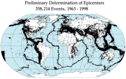
subduction zones. The longest earthquake ruptures on strike-slip faults, like the San Andreas Fault (1857, 1906), the North Anatolian Fault in Turkey (1939)...
84 KB (9,165 words) - 19:23, 15 April 2025
Krubera Cave (section Hydrogeology)
fractures and faults and exhibit complex winding patterns in the plan view, remaining largely within and near the anticlinal crest zone. The caves are...
44 KB (5,805 words) - 17:26, 3 April 2025
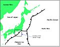
Nankai Trough (category Seismic faults of Japan)
transformation in the Nankai trough: Effects on subduction zone mechanics and hydrogeology, Paper, No. 245-10, 2005 Salt Lake City Annual Meeting. Saito...
20 KB (2,898 words) - 17:39, 3 April 2025
category hydrogeology fits into, Groundwater energy balance: groundwater flow equations based on the energy balance. Fault zone hydrogeology: field specifically...
6 KB (823 words) - 17:35, 18 August 2021
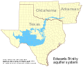
Edwards Aquifer (section Hydrogeology)
Regulated Zones". ArcGIS. ESRI. Retrieved 17 October 2015. Smith, Brian A; Darling, Bruce (2017). "Hydrogeology of the Saline Edwards Zone, Southeast...
64 KB (7,611 words) - 17:28, 21 March 2025

Water table (category Hydrogeology)
targets Groundwater recharge – Groundwater that recharges an aquifer Hydrogeology – Study of the distribution and movement of groundwater Watertable control –...
9 KB (1,076 words) - 02:44, 5 March 2025

Hikurangi Margin (category Seismic faults of New Zealand)
Hikurangi Subduction Zone) is New Zealand's largest subduction zone and fault. The Hikurangi Subduction Zone is an active subduction zone extending off the...
15 KB (1,404 words) - 06:43, 15 April 2025

Geology of Arizona (section Hydrogeology)
orthoclase crystals. The orogeny generated the Texas Zone, an area of fractures, fissures and faults in rock, trending northwest from Texas to California...
19 KB (2,705 words) - 18:45, 27 November 2024
shock is transformed into the hydraulic impact within fluid-saturated fault zone. He was through with his gymnasium in 1918 and graduated from Leningrad...
3 KB (431 words) - 19:12, 2 November 2024
caves, the primary process that determines essential features of the hydrogeology of karst and guides its evolution. It often deals with the development...
3 KB (359 words) - 15:11, 12 September 2024
[Predicting seismic landslide hazard in the Batang fault zone of the Qinghai-Tibet Plateau]. Hydrogeology & Engineering Geology (in Chinese). 48 (5). China...
6 KB (518 words) - 06:13, 29 January 2025
Darling Scarp South West Seismic Zone Kern, A. M.; Geological Survey of Western Australia (1988), The geology and hydrogeology of the superficial formations...
11 KB (1,327 words) - 10:09, 5 April 2025
Geology of Eswatini (section Hydrogeology)
Soil Technology. 11 (3): 229–246. doi:10.1016/S0933-3630(97)00010-X. "Hydrogeology of Swaziland". British Geological Survey. "2010 Minerals Yearbook: Lesotho...
5 KB (625 words) - 10:05, 5 April 2025
Geology of Madeira (section Hydrogeology and soils)
and cold, although there are small quantities of thermal water near fault zones. Much of the water on the island comes from high-discharge springs. Leptosols...
6 KB (678 words) - 09:10, 14 July 2024
seismogenic zone along subduction megathrusts. Earth and Planetary Science Letters 215 (1-2), 219-235. Saffer, D.M., Tobin, H.J., 2011. Hydrogeology and mechanics...
11 KB (1,289 words) - 13:12, 25 January 2024

World Impact Crater list by Anna Mikheeva lists it as "potential". The hydrogeology of DRC is poorly researched, although individual areas have been studied...
13 KB (1,700 words) - 07:34, 5 April 2025

Geology of Sudan (section Hydrogeology)
Red Sea depression is not bounded by faults; rather, it formed beginning in the Carboniferous as a subsidence zone and continued to develop in the Mesozoic...
8 KB (1,032 words) - 10:01, 12 May 2024
Observatory (USArray) These observatories consisted of boreholes into an active fault zone, global positioning system (GPS) receivers, tiltmeters, long-baseline...
34 KB (4,457 words) - 04:01, 31 March 2025
the geophysical methods for mapping subsurface properties combine with hydrogeology to use proper, accurate methods to map shallow hydrological study sites...
7 KB (781 words) - 18:39, 4 June 2022

rock units slide past one another, strike-slip faults develop in shallow regions, and become shear zones at deeper depths where the rocks deform ductilely...
87 KB (9,679 words) - 19:36, 4 April 2025
Geology of Cameroon (section Hydrogeology)
CAMZ is divided by the Foumban Shear Zone. The Douala Basin is defined by northeast-southwest strike-slip faults and was divided from the Rio-del-Rey...
7 KB (921 words) - 02:44, 5 April 2025
of karst include the Caribbean, China, and Australia. Typical karst hydrogeology consists of a network of interconnected fissures, fractures, and conduits...
12 KB (979 words) - 08:41, 22 April 2024

groundwater conditions. Zones of similar potential earthquake shaking are thus determined and drawn on maps. The well known San Andreas Fault is illustrated as...
10 KB (1,160 words) - 20:38, 10 November 2024

center zone reaches over 10,000 m (33,000 ft). The northern part of the basin appears steep in the west and gentle in the east on the profile. Five fault structural...
42 KB (4,710 words) - 16:52, 11 March 2025