Surveyors Range (81°37′S 160°15′E / 81.617°S 160.250°E / -81.617; 160.250) is a 30 miles (48 km) long mountain range in the Churchill Mountains of...
14 KB (1,832 words) - 19:24, 9 March 2024
professional body of surveyors. Chartered Surveyors are entitled to use "MRICS" or "FRICS" after their names as appropriate. Chartered Surveyors are highly trained...
15 KB (1,444 words) - 20:37, 27 March 2024

hours (2.7 days). The launch weights (at lunar injection) of the seven Surveyors ranged from 995.2 kilograms (2,194 lb) to 1,040 kilograms (2,290 lb), and...
20 KB (2,061 words) - 00:06, 5 October 2024

for marine surveyors. The U.S. Coast Guard does not approve or certify marine surveyors; however, it adopted Navtech USSA Marine Surveyor practices in...
14 KB (1,818 words) - 16:39, 20 June 2024

Churchill Mountains (category Mountain ranges of the Ross Dependency)
Nimrod Glacier. Surveyors Range (81°37′S 160°15′E / 81.617°S 160.250°E / -81.617; 160.250 (Surveyors Range)), a 30 miles (48 km) long range extending north...
10 KB (1,231 words) - 16:22, 14 March 2024
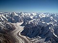
Karakoram (redirect from Karakoram Range)
explorers first visited early in the 19th century, followed by British surveyors starting in 1856. The Muztagh Pass was crossed in 1887 by the expedition...
29 KB (2,541 words) - 00:51, 28 September 2024

the Institution of Surveyors, it received a royal charter in 1881, and in 1947 became the Royal Institution of Chartered Surveyors. With a London HQ and...
49 KB (4,924 words) - 09:32, 27 June 2024
Ahern Glaciers to the west side of Starshot Glacier. It faces the Surveyors Range on the east side of the Starshot Glacier. It was named by the New Zealand...
8 KB (788 words) - 23:05, 11 July 2024

Public Land Survey System (redirect from Federal Township-Range Survey System)
remaining). On the exposed wood of the blaze, surveyors were required to inscribe, with wood chisels, township, range and section information, on typically either...
53 KB (6,039 words) - 19:16, 28 August 2024
Construction surveying (redirect from Building surveyor)
Surveyors, these courses are accredited by the Royal Institution of Chartered Surveyors. Other professional organisations that have building surveyor...
17 KB (2,019 words) - 07:37, 30 January 2024
southern end of the range. The Holyoake Range lies to the southwest of the Nash Range. The Surveyors Range is to the northwest. The range was named by the...
12 KB (1,641 words) - 16:13, 31 August 2024
Starshot Glacier, separating the Surveyors Range and Holyoake Range. It was seen by the Holyoake, Cobham and Queen Elizabeth Ranges party of the New Zealand Geological...
8 KB (798 words) - 14:31, 21 December 2023

Creek Granite boulders on Surveyors Creek Mulligans Hut Christmas bells in sedge heath near Surveyors Creek "Gibraltar Range National Park". N.S.W. National...
4 KB (233 words) - 23:44, 1 July 2024

surveyors in the core of the profession may offer mortgage valuations, homebuyer's survey and valuations, full building surveys, building surveyors'...
15 KB (1,851 words) - 17:29, 28 June 2024

Surveyor 1 was the first lunar soft-lander in the uncrewed Surveyor program of the National Aeronautics and Space Administration (NASA, United States)...
14 KB (1,560 words) - 16:37, 2 October 2024

the area as Dumbara Kanduvetiya meaning Mist-laden Mountain Range. Early British surveyors gave the name knuckles, referring to a series of recumbent folds...
8 KB (631 words) - 10:57, 20 August 2024

reflectivity data. This spacecraft was similar in design to the previous Surveyors, but it carried more scientific equipment including a television camera...
15 KB (1,649 words) - 20:23, 26 June 2024

Rangefinder (redirect from Range finder)
military, and space travel. They were especially useful for finding the range of a target, such as in naval gunnery and anti-aircraft artillery. The word...
10 KB (1,184 words) - 14:20, 12 July 2024
Length measurement (redirect from Range finding)
measurement, distance measurement, or range measurement (ranging) refers to the many ways in which length, distance, or range can be measured. The most commonly...
26 KB (3,394 words) - 02:54, 14 March 2024
in the way of the path may have to be accounted for separately. Good surveyors will keep track of any circumstance on the path that can influence the...
7 KB (899 words) - 09:15, 13 November 2023
through the Churchill Mountains, then north along the west side of Surveyors Range, entering the Ross Ice Shelf south of Cape Parr. It merges with the...
6 KB (831 words) - 20:05, 18 January 2024

specialized technicians. Unlike land surveyors, the resulting plan does not have legal status. Construction surveyors perform the following tasks: Surveying...
38 KB (3,980 words) - 04:41, 19 September 2024
cadre of professional Surveyors - many of whom had been Royal Engineers In 1890, the Association of Provincial Land Surveyors was launched during a two-day...
23 KB (2,804 words) - 16:05, 8 January 2024
nautical miles (22 km) long, flowing north along the east side of the Surveyors Range to enter Beaumont Bay, Ross Ice Shelf. It was named by the Advisory...
885 bytes (118 words) - 23:38, 7 April 2023

The Stirling Range or Koikyennuruff is a range of mountains and hills in the Great Southern region of Western Australia, 337 kilometres (209 mi) south-east...
17 KB (1,873 words) - 16:12, 24 August 2024

official border. Since there were no qualified land surveyors in South Africa then, three main surveyors were brought in from Europe, including Von Weilligh...
9 KB (758 words) - 05:30, 19 September 2024

Gunter's chain (redirect from Surveyor's chain)
Measures for the British Isles Denny, Milton. "The Colonial Surveyor in Pennsylvania", Surveyors Historical Society, 2013. Instruments used in Surveying Archived...
13 KB (1,392 words) - 13:55, 29 June 2024
Explorers Range (70°50′S 162°45′E / 70.833°S 162.750°E / -70.833; 162.750 (Explorers Range)) is a large mountain range in the Bowers Mountains of Victoria...
17 KB (2,974 words) - 21:30, 6 March 2024
Theodolite (transit) Total station and prism Compass (prismatic and surveyor) Ranging rods Measuring tape Level staff Tripod stand (for optical instruments)...
7 KB (602 words) - 23:01, 11 August 2024