
Vieux-Rouen-sur-Bresle (French pronunciation: [vjø ʁwɑ̃ syʁ bʁɛl], literally Old Rouen on Bresle) is a French commune in the Seine-Maritime department...
3 KB (268 words) - 12:56, 30 August 2022

5 June 2019, accessed 17 November 2022 "Rouen . visite-de-rouen.com . Place du Vieux Marché". Visite-de-rouen.com. Archived from the original on 28 September...
41 KB (3,799 words) - 22:36, 26 June 2024

Blangy-sur-Bresle (French pronunciation: [blɑ̃ʒi syʁ bʁɛl], literally Blangy on Bresle) is a commune in the department of Seine-Maritime in the Normandy...
3 KB (223 words) - 10:57, 3 August 2022

in the region of Normandy. It is located on the Channel coast, north of Rouen at the mouth of the river Arques and lies east of the mouth of the river...
32 KB (2,885 words) - 09:50, 6 June 2024
most visited along with Bénédictine distillery and museum at Fécamp, the Rouen Cathedral and the Claude Monet Foundation in Giverny. During the eighteenth...
12 KB (1,112 words) - 15:46, 25 April 2024

population of the greater Le Havre conurbation is smaller than that of Rouen. After Reims, it is also the second largest subprefecture in France. The...
139 KB (15,602 words) - 12:53, 11 July 2024

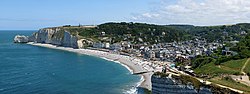
(22 mi) northeast of Le Havre, and around 60 kilometres (37 mi) northwest of Rouen. According to its late medieval founding legend, the trunk of a fig tree...
15 KB (1,690 words) - 14:56, 15 May 2024

department in the Normandy region in north-western France. It lies on the River Bresle. The town's Latin name was Alba Marla. It was raised by William the Bastard...
6 KB (523 words) - 01:17, 9 February 2023

town is the fifth-largest suburb of the city of Rouen and lies directly adjacent to the north side of Rouen at the junction of the D121 and D43. In addition...
7 KB (592 words) - 17:22, 5 August 2023

Abbeville = Talence > Tolente). The road to Paris passes near the Vieux-Rouen-sur-Bresle, which has been identified with the character Himbaldus (Château-Hubault)...
92 KB (9,432 words) - 16:11, 23 January 2024
Varenne), St. Ouen (who introduced monasteries to Rouen) and St. Wandrille of Normandy. The bishops of Rouen are also depicted. Among the bishops are the 7th...
7 KB (698 words) - 02:58, 28 January 2024
junction of the D 940, the D 78 and the D 1015 roads. The mouth of the river Bresle meets the English Channel here, in between the high (110 metres or 360 feet)...
10 KB (981 words) - 08:08, 22 March 2024

Sotteville-lès-Rouen (French pronunciation: [sɔtvil lɛ ʁwɑ̃], literally Sotteville near Rouen) is a commune and railway town in the Seine-Maritime department...
4 KB (272 words) - 22:25, 12 December 2023
Pays de Caux were concentrated on the coast of Petit-Caux and in Vieux-Rouen-sur-Bresle. According to David Bates, he also received estates around Breteuil...
6 KB (818 words) - 21:35, 1 May 2024

building of the city walls, pierced by three gates (Porte d'Eure, Porte de Rouen and Montivilliers Gate). These were restored in the 15th century after the...
12 KB (1,380 words) - 13:42, 30 December 2023

bank of the river Seine, in the Roumois some 10 miles (16 km) southwest of Rouen at the junction of the D 45 with the D 265 road. A fifteenth-century timber...
3 KB (198 words) - 15:51, 30 October 2023

Petit-Couronne (category Rouen geography stubs)
by the banks of the Seine, just 4 miles (6.4 km) south of the centre of Rouen at the junction of the D3 and the N338 roads. Menhirs from pre-Roman times...
4 KB (203 words) - 12:31, 23 September 2022
Landes-Vieilles-et-Neuves Marques Morienne Nullemont Richemont Ronchois Vieux-Rouen-sur-Bresle Communes of the Seine-Maritime department CC du Canton d'Aumale...
2 KB (122 words) - 17:36, 3 April 2022
northeast of Rouen near the junction of the D206 with the D122 road. The A28 autoroute forms the western border of the commune. Longuerue-Vieux-Manoir station...
2 KB (143 words) - 12:55, 30 August 2022
Tilloy-Floriville Vieux-Rouen-sur-Bresle Villers-sous-Foucarmont Vismes Arrêté préfectoral 29 November 2016 CC interrégionale Aumale - Blangy-sur-Bresle (N° SIREN :...
4 KB (213 words) - 07:57, 12 December 2022

the RD 940 and the RD 1314 roads, in the steep-sided valley of the river Bresle, whose mouth is 4 km (2.5 mi) away to the north-west in Le Tréport. Eu station...
6 KB (589 words) - 17:55, 29 September 2023
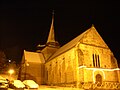
the D3 roads. The commune is served by the TER railway between Dieppe and Rouen. The church of St.Pierre, dating from the eleventh century. Ruins of an...
3 KB (195 words) - 20:50, 27 August 2022

of the river Andelle in the Pays de Bray, some 15 miles (24 km) east of Rouen at the junction of the D62 and the D238 roads. The church of Saint-Ouen...
3 KB (162 words) - 12:10, 23 September 2022
centred on the town of Aumale. The altitude varies from 76 m (Vieux-Rouen-sur-Bresle) to 246 m (Conteville with an average altitude of 187 m. The canton...
2 KB (192 words) - 11:07, 25 March 2022
village situated in the Pays de Caux, some 13 miles (21 km) northwest of Rouen on the D20 road. St. Martin's church, dating from the sixteenth century...
2 KB (112 words) - 19:23, 4 December 2022
"e" (Valéry) is incorrect. The town is located 37 miles (60 km) north of Rouen. A small fishing port and light industrial town situated in the Pays de...
7 KB (598 words) - 06:06, 26 February 2024
village situated in the Pays de Caux, some 11 miles (18 km) northwest of Rouen at the junction of the D20, D86 and the D64 roads. The church of St.Marguerite...
3 KB (131 words) - 12:36, 23 September 2022

the river Crevon in the Pays de Caux, some 10 miles (16 km) northeast of Rouen, at the junction of the D12, D7 and the D98 roads. Medieval place-name in...
5 KB (474 words) - 19:23, 11 July 2024

forestry situated in the Pays de Caux, some 9 miles (14 km) northeast of Rouen at the junction of the D53 and the D87 roads. The church of St. Georges...
2 KB (148 words) - 11:19, 18 February 2023

La Vieux-Rue (French pronunciation: [la vjø ʁy]) is a commune in the Seine-Maritime department in the Normandy region in northern France. La Vieux-Rue...
2 KB (146 words) - 08:56, 31 May 2023