
測量法施行令第2条第2項 国土地理院時報 (PDF). 1.1.5離島の高さ (in Japanese). 2003. p. 6. 2万5千分1地形図の読み方・使い方 (in Japanese). Kokudo Chiriin. Archived from the original on 2012-07-24...
6 KB (598 words) - 21:22, 10 January 2024

Edward Elgar Publishing. pp. 36, 194, 203. ISBN 9781786437969. 平成14年2万5千分1地形図図式 [2002 1:25000 Topographical Map Scheme] (in Japanese). Geospatial Information...
176 KB (18,018 words) - 16:07, 28 August 2024

(November 25, 1999). Accessed January 27, 2019.") (in Japanese) 1/25000地形図の発行年・発行図歴一覧 宮古・八重山地方 国土地理院] ("List of publication years and publication history...
24 KB (2,793 words) - 04:05, 27 July 2024

etsuran sābisu 2 man 5 sen-bu 1 chikei-zu-mei: Fujisan (Kōfu)" 地図閲覧サービス 2万5千分1地形図名: 富士山(甲府) [Map viewing service 1:25,000 topographic map name: Mt. Fuji (Kofu)]...
68 KB (6,113 words) - 19:03, 29 August 2024
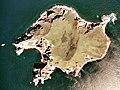
caldera. Islands portal Desert island Lists of islands 地図閲覧サービス 2万5千分1地形図名: (内挿図又は図葉外). 25,000:1 Topographical Map (in Japanese). Geographical Survey Institute...
6 KB (475 words) - 23:21, 27 April 2023

2010. 地図閲覧サービス 2万5千分1地形図名: 紋別(紋別) (in Japanese). Geospatial Information Authority of Japan. Retrieved 25 June 2010. 地図閲覧サービス 2万5千分1地形図名: 中渚滑(紋別) (in Japanese)...
10 KB (634 words) - 20:49, 22 February 2024
Kamuiwakka Hot Falls". Shari Town. Retrieved 24 March 2011. 地図閲覧サービス 2万5千分1地形図名: 知床五湖(知床岬). 25000:1 Topographical Map 知床五湖 (in Japanese). Geographical Survey...
1 KB (83 words) - 19:18, 7 February 2024
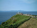
Hokkaido across the Tsugaru Strait can be seen from this location. 国土地理院の地形図 [Geospatial Information Authority Topographic Map] (Map) (in Japanese). Geospatial...
3 KB (228 words) - 06:13, 21 August 2023

Park, Hokkaidō, Japan. It is an andesitic stratovolcano. 地図閲覧サービス 2万5千分1地形図名:白雲岳(旭川) (in Japanese). Geospatial Information Authority of Japan. Retrieved...
2 KB (79 words) - 18:01, 21 July 2024
formed under low-to-mid pressure 50–20 million years ago. 地図閲覧サービス 2万5千分1地形図名: 上トマム(夕張岳). 地図閲覧サービス 2万5千分1 (in Japanese). Geographical Survey Institute...
2 KB (161 words) - 17:34, 4 July 2024

『山の地図と地形』 山と渓谷社、1996年 梅沢俊、瀬尾央 『新版・空撮登山ガイド1 北海道の山々』 山と渓谷社、1995年 Wikimedia Commons has media related to Mount Kamuiekuuchikaushi. 国土地理院 地図閲覧サービス 2万5千分1地形図名:...
5 KB (534 words) - 11:07, 2 September 2024

14 January 2024. Retrieved 2 February 2024. "根室本線の狩勝峠越え―1:50,000地形図「新得」,1:25,000地形図「狩勝峠」「新得」―". Archived from the original on 31 August 2010. Retrieved...
4 KB (351 words) - 16:54, 10 May 2024

needed] List of mountains in Japan List of volcanoes in Japan 地図閲覧サービス 2万5千分1地形図名: 斜里岳(斜里). 25000:1 Topographical maps (in Japanese). Geographical Survey...
4 KB (233 words) - 18:57, 9 August 2024

kilometres (50 mi), the river empties into the Pacific Ocean. 地図閲覧サービス 2万5千分1地形図名: 幌尻岳(夕張岳) (in Japanese). Geographical Survey Institute. Retrieved 2009-05-20...
4 KB (149 words) - 18:57, 25 February 2022
northerly direction until it flows into the Shokotsu River. 地図閲覧サービス 2万5千分1地形図名: 北見滝下(紋別) (in Japanese). Geospatial Information Authority of Japan. Retrieved...
3 KB (69 words) - 20:05, 15 January 2022

next day a lone hiker was found dead on Mount Tomuraushi. 地図閲覧サービス 2万5千分1地形図名: トムラウシ山(旭川) (in Japanese). Geospatial Information Authority of Japan. Retrieved...
3 KB (236 words) - 03:42, 27 May 2024

"Senjoga-dake, Japan". Peakbagger.com. Retrieved 2019-03-06. 地図閲覧サービス 2万5千分1地形図名: 仙丈ヶ岳(甲府) (in Japanese). Geographical Survey Institute. Retrieved 2008-08-14...
7 KB (512 words) - 08:58, 29 September 2023

basalt. List of volcanoes in Japan List of mountains in Japan 地図閲覧サービス 2万5千分1地形図名: 海別岳(斜里). 25000:1 Topographical maps (in Japanese). Geographical Survey...
3 KB (118 words) - 19:19, 9 August 2024

the original on 25 September 2012. Retrieved 16 July 2010. 地図閲覧サービス 2万5千分1地形図名: 石山(札幌) (in Japanese). Geospatial Information Authority. Retrieved 16 July...
4 KB (152 words) - 02:40, 8 June 2024

Elementary School List of railway stations in Japan 大日本帝國陸地測量部, 「船橋」 大正6年測図 2.5万地形図 "京成線各駅で「駅ナンバリング」を導入いたします" ["Station numbering" will be introduced to each...
4 KB (297 words) - 16:08, 14 August 2023

Bank Group. Archived from the original on 2015-10-16. Retrieved 2015-10-11. "地形分類" (PDF). Geospatial Information Authority of Japan. Archived (PDF) from the...
160 KB (15,342 words) - 18:26, 1 August 2024