
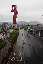
Chicoloapan de Juárez is the municipal seat and largest city in the municipality of Chicoloapan in State of Mexico, Mexico. It is located in the eastern...
9 KB (473 words) - 03:34, 25 October 2024

municipalities: Chimalhuacán, Chicoloapan, Ixtapaluca, Chalco de Solidaridad. It is largely rural. Chicoloapan Ixtapaluca Regiones y Municipios COPLADEM v t e...
700 bytes (55 words) - 06:08, 22 March 2024

José de la Palma, Municipio de Ixtapaluca, was built in 1989. The municipality is bordered by Chalco, Valle de Chalco Solidaridad, Chicoloapan, La Paz...
8 KB (529 words) - 17:14, 21 February 2025

Atenco, Tepetlaoxtoc, Papalotla, Chiautla, Chiconcuac, Chimalhuacán, Chicoloapan, Ixtapaluca, Ciudad Nezahualcóyotl, Ecatepec as well as the states of...
43 KB (4,250 words) - 03:14, 22 February 2025
Texcoco, Chicoloapan, and La Paz. The city is the sixth largest in the state in population (after Ecatepec de Morelos, Nezahualcóyotl, Naucalpan de Juárez...
9 KB (509 words) - 00:16, 11 January 2025
municipality borders the municipalities of Ixtapaluca, Chicoloapan, Los Reyes Acaquilpan, al oriente con Chalco de Díaz Covarrubias and borders to the south with...
6 KB (654 words) - 03:41, 25 October 2024
org/web/20131031113048/http://centrodedescargas.cnig.es/CentroDescargas/equipamiento/BD_Municipios-Entidades.zip. Archived from the original on 2013-10-31. Retrieved 2021-01-09...
24 KB (183 words) - 14:52, 13 December 2024

Nacional de Información Municipal" (in Spanish). SEGOB. 2010. Retrieved 4 November 2017. "San José del Rincón". Enciclopedia de los Municipios y Delegaciones...
10 KB (676 words) - 18:48, 23 November 2024

reported a population of 253,845. It borders with Chicoloapan, Chimalhuacán, Ixtapaluca, Valle de Chalco Solidaridad, Nezahualcoyotl and the Distrito...
10 KB (659 words) - 17:58, 21 February 2025
movement started in San Francisco Acuautla, Coatepec and San Vicente Chicoloapan, it is also executed on July 9, 1868 within the school of Lightning and...
17 KB (1,744 words) - 15:34, 21 February 2025
Almoloya de Juárez, Amecameca de Juárez, Chicoloapan de Juárez and Chiconcuac de Juárez – Benito Juárez, President Apaxco de Ocampo – Melchor Ocampo, politician...
87 KB (9,697 words) - 22:42, 14 January 2025

del Valle de México". La Jornada. Retrieved July 10, 2024. René Ramón (July 2, 2024). "Continúan los estragos por fuertes lluvias en Chicoloapan, Edomex"...
27 KB (2,876 words) - 01:56, 2 March 2025

Chalco, Chicoloapan, Ecatzingo, Ixtapaluca, Juchitepec, Ozumba, Temamatla, Tenango del Aire, Tepetlixpa and Tlamanalco, with its head town at Chalco de Díaz...
17 KB (909 words) - 02:56, 4 February 2025
south-east of Chimalhuacán. 1996–2005 The municipalities of Chimalhuacán and Chicoloapan and one neighbourhood in Nezahualcóyotl. The head town was at Chimalhuacán...
17 KB (972 words) - 03:02, 4 February 2025
municipalities of Chicoloapan and La Paz. The head town was at Los Reyes Acaquilpan. Districts 25 and 30 cover the remainder of Chimalhuacán. "Memoria de la Distritación...
12 KB (763 words) - 03:29, 4 February 2025
City urban area and comprises two of the state's 125 municipalities: Chicoloapan (in its entirety) and Chimalhuacán (eastern and south-eastern parts)...
16 KB (924 words) - 03:06, 4 February 2025