
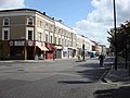
The A4010 is an important primary north–south road in Buckinghamshire, Southern England. It runs from High Wycombe at Junction 4 of the M40 motorway to...
6 KB (573 words) - 05:18, 13 September 2023

2.5 miles (4.0 kilometres) north east from Princes Risborough on the A4010 road. The parishes of Kimble have first and foremost been a farming community...
26 KB (3,774 words) - 18:19, 9 August 2024
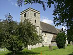
parish in Buckinghamshire, England. It is near Saunderton, off the main A4010 road between Princes Risborough and High Wycombe. The village name is Anglo-Saxon...
7 KB (788 words) - 17:25, 29 December 2023
through the Chilterns; the south end of which is at West Wycombe. The A4010 road follows this route from West Wycombe through the town and then on to Aylesbury...
53 KB (7,860 words) - 17:51, 17 October 2024

Handy Cross roundabout (section Roads served)
roundabout to Cressex and on through Wycombe to the A40-the new road was given the A4010 road number. In 2006, the Highways Agency constructed several improvements...
3 KB (422 words) - 12:22, 10 September 2024

Lee, about 2 miles (3 km) further south and a residential area on the A4010 road around Saunderton railway station (on the Chiltern Main Line), it is 5...
6 KB (561 words) - 20:41, 6 May 2024

List of A roads in zone 4 in Great Britain starting north of the A4 and south/west of the A5 (roads beginning with 4). Only roads that have individual...
70 KB (79 words) - 20:36, 17 September 2024

town of Aylesbury and 9.5 miles (15.3 km) north of High Wycombe, on the A4010 road. Until 1934 Monks Risborough was also a separate civil parish, but it...
30 KB (4,482 words) - 19:58, 20 March 2024
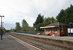
Saunderton railway station is a railway station on the A4010 road between High Wycombe and Princes Risborough, in Buckinghamshire, England. It is located...
5 KB (347 words) - 00:46, 17 December 2023

Loosley Row, stretched over to Bledlow Ridge, across what is now the A4010 road. The underlying geology consists of chalk which typifies the area around...
7 KB (669 words) - 20:06, 13 January 2024

blue brick, which carries the Chiltern Main Line over the A4010 road. Beneath Springfield Road in Swindon, the disused Midland and South Western Junction...
73 KB (8,387 words) - 21:01, 9 July 2024
over the current Station Road and through the current RAC industrial estate. It approached Cores End, crossed the A4094 road and entered the agricultural...
12 KB (1,308 words) - 13:17, 5 September 2024

B roads are numbered routes in Great Britain of lesser importance than A roads. See the article Great Britain road numbering scheme for the rationale behind...
135 KB (82 words) - 16:10, 8 July 2024

The A5, the London-Holyhead trunk road, is a major road in England and Wales. It runs for about 243 miles (391 km) from London to the Irish Sea at the...
46 KB (1,741 words) - 22:40, 3 September 2024

A40 is a trunk road which runs between London and Goodwick (Fishguard), Wales, and officially called The London to Fishguard Trunk Road (A40) in all legal...
50 KB (2,934 words) - 11:37, 2 September 2024
the southern end of its network at Annesley (near Mansfield) to Quainton Road, in 1893. In addition, there was a two-mile section of independent route...
36 KB (4,961 words) - 11:15, 16 July 2024

major road in England from Central London to Avonmouth via Heathrow Airport, Reading, Bath and Bristol. It is historically known as the Bath Road with...
57 KB (4,600 words) - 22:45, 25 October 2023

The A41 is a trunk road between London and Birkenhead, England. Now in parts replaced by motorways, it passes through or near Watford, Kings Langley, Hemel...
47 KB (2,749 words) - 21:16, 23 September 2024
railway museum operated by the Quainton Railway Society Ltd. at Quainton Road railway station, about 5 miles (8.0 km) west of Aylesbury in Buckinghamshire...
30 KB (1,135 words) - 01:18, 28 September 2024

The Milton Keynes grid road system is a network of predominantly national speed limit, fully landscaped routes that form the top layer of the street hierarchy...
20 KB (2,609 words) - 15:17, 10 May 2024

The A421 is an important road for east/west journeys across south central England. Together with the A428, the A43 and A34, it forms the route from Cambridge...
13 KB (1,293 words) - 20:42, 26 September 2024
road in the United Kingdom that starts at Paddington in London and terminates near Maidenhead in Berkshire. It is 44.6 miles (71.8 km) long. The road...
11 KB (855 words) - 09:24, 4 October 2024

0°49′00″W / 51.83554°N 0.81659°W / 51.83554; -0.81659 The A413 is a major road in England that runs between Denham (west of London) to Towcester (northwest...
4 KB (419 words) - 20:54, 29 June 2023

Watling Street (redirect from A5183 road)
It was used by the ancient Britons and paved as one of the main Roman roads in Britannia (Roman-governed Great Britain during the Roman Empire). The...
40 KB (2,655 words) - 19:13, 11 July 2024
Britain road numbering scheme, the country is divided into numbered zones, the boundaries of which are usually defined by single-digit roads. The first...
25 KB (327 words) - 15:05, 14 September 2024

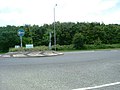
M40 motorway (category Infobox road maps for Wikidata migration)
westbound slip road without joining the roundabout and provision for the London-bound M40 to skip the section of the roundabout which serves the A4010, High Wycombe...
37 KB (3,639 words) - 11:36, 3 October 2024

h The B4319 is a road in Pembrokeshire in Wales. It starts from the A4139 at 51°40′23″N 4°54′43″W / 51.67306°N 4.91194°W / 51.67306; -4.91194 in Pembroke...
2 KB (151 words) - 22:05, 8 June 2024

The A428 road is a major road in central and eastern England. It runs between the cities of Coventry and Cambridge by way of the county towns of Northampton...
13 KB (1,167 words) - 15:52, 7 September 2024
Denham Roundabout (category Road junctions in England)
The Denham Roundabout is a road junction in Denham, Buckinghamshire. It was originally opened in 1943 in conjunction with the completion of the new Western...
3 KB (284 words) - 09:28, 27 August 2023
M4 motorway (category Infobox road instances in the United Kingdom)
Swindon, Bristol, Newport, Cardiff, Bridgend, Port Talbot and Swansea. A new road from London to South Wales was first proposed in the 1930s. In 1956 the Ministry...
58 KB (4,098 words) - 19:35, 10 October 2024