
State Route 243 (SR 243) is a 20-mile-long (32 km) route that serves as a connection between SR 195 east of Haleyville, Alabama, United States, with SR...
2 KB (104 words) - 00:15, 16 February 2024

The State Route System in Alabama uses the standard numbering convention: odd numbers signify a north–south state route, and even numbers signify an east–west...
113 KB (297 words) - 10:17, 3 October 2024
243: Manitoba Provincial Road 243 Prince Edward Island Route 243 Quebec Route 243 National Route 243 Japan National Route 243 Alabama State Route 243...
2 KB (182 words) - 23:25, 4 April 2024

Alabama State Route 13 (SR 13) from its southern terminus to an intersection in southeastern Fayette County. For the rest of its length in the state,...
40 KB (2,494 words) - 19:15, 30 August 2024

entirety of Alabama State Route 24 in Alabama from Alabama State Route 67 west to the Mississippi border is four-laned. In Decatur, Alabama, State Route 24 underwent...
12 KB (1,101 words) - 17:14, 12 September 2024

Alabama (/ˌæləˈbæmə/ AL-ə-BAM-ə) is a state in the Southeastern region of the United States. It borders Tennessee to the north, Georgia to the east, Florida...
225 KB (19,394 words) - 15:52, 26 September 2024

State Route 17 (SR 17) is a major north-to-south highway within the U.S. state of Alabama. Covering 346.562 miles (557.737 km), it travels the length...
15 KB (542 words) - 04:28, 1 October 2024

in the U.S. state of Alabama. The southern terminus of SR 195 is located at its intersection with SR 5 in Jasper. From this point the route travels in...
4 KB (176 words) - 00:12, 16 February 2024

leaving US Route 90 and US Route 98 in Spanish Fort, the route heads due east towards the town of Stapleton, where it joins Alabama State Route 59 (Gulf...
29 KB (1,237 words) - 14:24, 22 June 2023

2011. KML file (edit • help) Template:Attached KML/Alabama State Route 245 KML is from Wikidata Alabama Department of Transportation county road maps for...
3 KB (143 words) - 00:16, 16 February 2024

McIntosh Bluff), is a town located in Washington County, Alabama, United States along U.S. Route 43. It is 12+1⁄2 miles (20.1 km) south of Wagarville and...
9 KB (811 words) - 07:03, 22 September 2024

file (edit • help) Template:Attached KML/Alabama State Route 241 KML is from Wikidata "Milepost Web". Alabama Department of Transportation. Archived from...
3 KB (174 words) - 00:15, 16 February 2024

State Route 14 (SR 14) is a major east-to-west state highway in the U.S. state of Alabama. Spanning 218.289 miles (351.302 km), the highway begins at...
15 KB (570 words) - 10:33, 19 August 2024

of Sand Mountain, a southern extension of the Cumberland Plateau. Alabama State Route 35 passes through the town, connecting Fort Payne and Rainsville...
7 KB (684 words) - 07:23, 22 September 2024

This is a list of former state routes in the U.S. state of Georgia. This list represents routes that traveled through the state but are no longer in operation...
131 KB (11,471 words) - 22:52, 6 February 2024

county's history. U.S. Highway 278 State Route 5 State Route 13 State Route 33 State Route 129 State Route 195 State Route 243 Norfolk Southern Railway Haleyville...
21 KB (1,745 words) - 19:12, 27 March 2024

Interstate 59 (redirect from Georgia State Route 406)
Orleans, Louisiana; Birmingham, Alabama; and Chattanooga, Tennessee, running closely parallel to the older U.S. Route 11 (US 11) corridor for the entire...
35 KB (1,354 words) - 12:55, 25 September 2024

S. state of Alabama, U.S. Route 45 (US 45) is a 60-mile-long (97 km) north–south United States Highway in the east south central state of Alabama. It...
20 KB (1,285 words) - 16:14, 18 November 2023

43 State Route 13 State Route 17 State Route 19 State Route 24 State Route 172 State Route 187 State Route 237 State Route 241 State Route 243 State Route...
19 KB (1,465 words) - 22:04, 29 August 2024
water. Oak Mountain State Park, Alabama's largest state park, is located in Pelham. The city is located along U.S. Route 31, which runs directly through...
17 KB (1,383 words) - 07:20, 22 September 2024
Morgan County across a scattered area mostly between U.S. Route 72 on the north and State Route 24 to the south (though the town's municipal boundaries...
10 KB (944 words) - 07:04, 25 September 2024

U.S. Route 278 (US 278), mostly internally designated by the Alabama Department of Transportation as State Route 74 (SR 74), is a major east–west U.S...
21 KB (1,237 words) - 07:05, 25 September 2024

State Route 166 (SR 166) is a north–south state highway in southern Middle Tennessee, traversing Giles and Maury counties. Alabama State Route 127 becomes...
6 KB (299 words) - 10:43, 29 January 2024

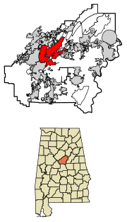
counties in north central Alabama, United States. Hoover is the largest suburban city in Alabama and the 6th largest city in Alabama. The population was 92...
31 KB (2,789 words) - 12:23, 5 September 2024

Fall Line Freeway (redirect from State Route 540 (Georgia))
as State Route 540 (SR 540), is a 215-mile-long (346 km) highway designed to span the width of the U.S. state of Georgia from Columbus at the Alabama state...
62 KB (6,099 words) - 00:38, 5 August 2024

Interstate 85 in Georgia (redirect from Georgia State Route 403)
northeast–southwest in the US state of Georgia. It enters the state at the Alabama state line near West Point, and Lanett, Alabama, traveling through the Atlanta...
45 KB (2,653 words) - 20:53, 2 September 2024
Tennessee state routes do not follow a systematic numbering system unlike the U.S. Highway System and some other states' highway systems. The routes are separated...
174 KB (349 words) - 06:30, 3 July 2024

Huntsville is the most populous city in the U.S. state of Alabama. It is the county seat of Madison County with portions extending into Limestone County...
151 KB (13,827 words) - 07:07, 3 October 2024

numbered state highways in the U.S. state of New York. Signed state highways in New York, referred to as "touring routes" by the New York State Department...
167 KB (908 words) - 11:59, 30 April 2024

passes through the northern end of town, with access via Exit 44 (Alabama State Route 59). According to the U.S. Census Bureau, the town has a total area...
11 KB (994 words) - 06:58, 22 September 2024