
Arizona State Route 143, also known as SR 143 and the Hohokam Expressway, is a north–south and access-controlled freeway in Maricopa County, Arizona, that...
13 KB (1,304 words) - 14:31, 3 July 2024
Roads and freeways in metropolitan Phoenix (redirect from Arizona State Route 50)
West Valley, respectively. State Route 51 connects Downtown with the northern reaches of the city, and Arizona State Route 143 is a distributor for Phoenix...
44 KB (4,579 words) - 00:58, 31 July 2024

State Route 85 (SR 85) is a 128.86-mile-long (207.38 km) state highway in the U.S. state of Arizona. The highway runs from the United States–Mexico border...
20 KB (1,696 words) - 21:00, 23 March 2024

Arizona State Route 202 (SR 202) or Loop 202 (202L) is a semi-beltway circling the eastern and southern areas of the Phoenix metropolitan area in central...
45 KB (3,333 words) - 16:31, 25 July 2024
Route 143 Malaysia Federal Route 143 U.S. Highway 143 (former) Alabama State Route 143 Arizona State Route 143 Arkansas Highway 143 California State Route...
4 KB (278 words) - 23:32, 4 April 2024

Arizona State Route 101 (SR 101) or Loop 101 is a semi-beltway looping around the Phoenix Metropolitan Area in central Arizona, United States. It connects...
25 KB (1,732 words) - 16:30, 25 July 2024
state of Arizona's State Routes are usually abbreviated as SR. The Arizona State Highway system was introduced on September 9, 1927, by the State Highway...
50 KB (1,442 words) - 23:47, 19 July 2024
State Route 153, also known as SR 153 and the Sky Harbor Expressway, is a former state highway in Maricopa County, in the U.S. state of Arizona, that...
9 KB (912 words) - 08:05, 20 April 2024
summary of the former state routes in Arizona, including mileage tables and maps. Between the establishment of Arizona's numbered state highway system in...
93 KB (8,974 words) - 22:00, 4 August 2024

U.S. Route 60 (US 60) is an east–west United States Highway within Arizona. The highway runs for 369 miles (594 km) from a junction with Interstate 10...
41 KB (2,441 words) - 01:44, 5 August 2024

Interstate 17 (redirect from Arizona State Route 79 (1950-1968))
is a north–south Interstate Highway located entirely within the US state of Arizona. I-17's southern terminus lies in Phoenix, at I-10/US 60 and its northern...
26 KB (1,457 words) - 00:57, 30 July 2024

County, Arizona in the southwestern United States. The highway is an old routing of U.S. Route 89 from Bitter Springs, Arizona to Kanab, Utah. The state of...
10 KB (742 words) - 05:04, 25 September 2022

Interstate 8 (redirect from Arizona State Route 8)
These were later replaced by U.S. Route 80 (US 80) across California and part of Arizona, and Arizona State Route 84 (SR 84) between Gila Bend and Casa...
112 KB (12,087 words) - 22:06, 4 August 2024

State Route 96 (SR 96), is an east–west, 21.79-mile-long (35.07 km) state highway in central part of the U.S. state of Arizona. It runs from Bagdad east...
7 KB (648 words) - 01:31, 8 September 2023

southerly is from Littlefield, Arizona, to St. George, Utah, where the two routes took different paths through the Arizona Strip. The more northerly and...
31 KB (3,030 words) - 05:04, 25 June 2024

In the U.S. state of Arizona, Interstate 10 (I‑10), the major east–west Interstate Highway in the United States Sun Belt, runs east from California, enters...
61 KB (4,277 words) - 09:20, 28 July 2024

US 80 include the entirety of both New Mexico State Road 80 and Arizona State Route 80, and all of County Route S80 in Imperial County, California. Other...
71 KB (8,228 words) - 20:53, 7 August 2024

U.S. Route 89 (US 89) in the U.S. state of Utah is a north-south United States Highway spanning more than 502 miles (807.891 km) through the central part...
61 KB (4,336 words) - 16:08, 12 October 2023
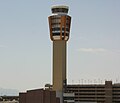
Phoenix Sky Harbor International Airport (redirect from Sky Harbor Airport, Arizona)
throughout the state. By road, the airport terminals are served by East Sky Harbor Boulevard, which is fed by Interstate 10, Arizona State Routes 143 and 202...
84 KB (4,868 words) - 23:34, 6 August 2024
A large number of minor routes in Utah, United States, were deleted by the State Legislature in 1969. This was by far the largest mass-decommissioning...
72 KB (9,241 words) - 17:15, 27 July 2024

loops in Arizona carry the unsigned designation of Arizona State Route 10 Business (or State Business Route 10). Individual loops along an Interstate are designated...
49 KB (3,403 words) - 20:01, 2 July 2024
Ash Fork is a census-designated place in Yavapai County, Arizona, United States. Its population was 396 at the 2010 U.S. Census, down from 457 in 2000...
13 KB (1,499 words) - 15:36, 26 April 2024

south-central part of the U.S. state of Arizona. As of the 2020 census the population was 4,420,568, or about 62% of the state's total, making it the fourth-most...
58 KB (4,075 words) - 05:57, 30 July 2024

Interstate 40 (I-40), business routes are found in the five westernmost states through which I-40 passes, California, Arizona, New Mexico, Texas, and Oklahoma...
81 KB (7,386 words) - 16:08, 14 April 2024

U.S. state of Arizona, with 1,608,139 residents as of 2020. It is the fifth-most populous city in the United States and the most populous state capital...
204 KB (19,426 words) - 04:04, 8 August 2024

Interstate 10 (redirect from Interstate Route 10)
section was completed in 1990. I-10 stretches from the Pacific Ocean at State Route 1 (SR 1, Pacific Coast Highway) in Santa Monica, California, to I-95...
38 KB (3,947 words) - 23:42, 26 July 2024

Interstate 15 in California (redirect from California State Route 15)
Route 15, consisting of the contiguous segments of State Route 15 (SR 15) and Interstate 15 (I-15), is a major north–south state highway and Interstate...
59 KB (4,223 words) - 22:03, 4 August 2024

provided a shorter route between Ellensburg and Blewett Pass. SR 131 was later reassigned in 1991 to a short highway near Randle. State Route 143 was a short...
37 KB (3,406 words) - 03:19, 15 June 2024

Interstate 40 in California (redirect from California State Route 40 (1964))
the California Department of Transportation. I-40 from I-15 to the Arizona state line is known as the Needles Freeway, as named by Senate Concurrent...
12 KB (925 words) - 08:18, 25 December 2023

County to the east, and the Mexican state of Sonora to the south. Santa Cruz County includes the Nogales, Arizona Micropolitan Statistical Area, which...
23 KB (1,876 words) - 01:54, 15 June 2024