and joins the Taunton River near Assonet Neck in Berkley, Massachusetts. The Assonet River is formed from the Cedar Swamp River near the border of Freetown...
5 KB (586 words) - 16:55, 7 May 2024
the town, Assonet was settled in 1659 along with the city of Fall River, then a part of Freetown. It rests on the banks of the Assonet River. As of the...
22 KB (2,703 words) - 17:15, 3 May 2024
Assonet may refer to: Assonet, Massachusetts Assonet River Assonet Bay This disambiguation page lists articles about distinct geographical locations with...
107 bytes (44 words) - 18:11, 27 December 2019
and the Sakonnet River. Freetown is currently home to two Historic Districts of the National Register of Historic Places: the Assonet Village Historic...
34 KB (3,911 words) - 22:19, 1 July 2024
Assonet Bay is a lake in Assonet, a village within the town of Freetown, Massachusetts. The Assonet River connects the waters of the bay with the Taunton...
747 bytes (56 words) - 02:25, 28 April 2019
Westport River Taunton River Quequechan River Assonet River Cedar Swamp River Segreganset River Three Mile River Rumford River Wading River Mill River Snake...
20 KB (1,631 words) - 12:37, 4 July 2024
and the Assonet section of Freetown, to Fall River where it joins Mount Hope Bay, an arm of Narragansett Bay. The total length of the river is 37.0 miles...
10 KB (764 words) - 16:11, 22 September 2023
Dam – Mill River Tisdale Dam – Assonet River Tracy Pond Dam – Forge River Tully Dam – Millers River Turners Falls Dam – Connecticut River Unnamed dam...
41 KB (3,524 words) - 03:57, 15 July 2024
crossings of the Assonet River in Bristol County, Massachusetts from its confluence with the Taunton River upstream to the Cedar Swamp River. List of crossings...
2 KB (37 words) - 14:26, 27 April 2024
River - Ohio Ashuelot River - New Hampshire Assabet River - Massachusetts Assonet River - Massachusetts Atchafalaya River - Louisiana Au Sable River -...
5 KB (363 words) - 15:34, 2 May 2024
town of Freetown (about a third of the town) dividing Assonet, East Freetown, and Fall River's northernmost boundary. The forest land includes Profile...
14 KB (1,304 words) - 21:21, 11 May 2024
The Assonet Burying Ground is the main public cemetery for Freetown, Massachusetts. Prior to becoming a cemetery, the land occupied by the Assonet Burying...
3 KB (350 words) - 02:34, 14 October 2023
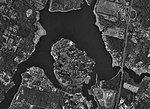
Berkley Neck which points into the confluence of the Taunton River and the Assonet River, there is a small island, named "Conspiracy Island", whose name...
17 KB (1,775 words) - 02:55, 5 June 2024
it forms the Assonet River near the Freetown line, just south of the village of Myricks. It is a tributary of the Taunton River. The river is crossed by...
1 KB (142 words) - 23:17, 25 April 2024
canoes" (possible portage spot) Annisquam (and river) Assinippi: (Wampanoag) "rocks in water" Assonet River (also Cedar Swamp and village): (Narragansett)...
9 KB (802 words) - 00:56, 10 May 2024
South Main Street. (South Main Street southbound in Assonet connects to North Main Street in Fall River.) The route passes through the village before turning...
15 KB (1,281 words) - 13:19, 1 July 2024
"place of large upright rock" Assinippi: (Wampanoag) "rocks in water" Assonet River (also Cedar Swamp and village): (Narragansett) "at the rock" – the rock...
30 KB (3,164 words) - 09:16, 17 June 2024
Freetown station (redirect from Assonet station)
Freetown station is a future MBTA Commuter Rail station located in the Assonet village of Freetown, Massachusetts. It is planned to open in May 2025 as...
15 KB (1,313 words) - 03:12, 14 June 2024
at Assonet Bay by members of the Massachusetts Bay Colony as part of Freeman's Purchase, which included the northern part of what is now Fall River. In...
104 KB (10,208 words) - 00:29, 29 June 2024
Wampanoag (redirect from Assonet Band)
of Wampanoag descent include: Assawompsett-Nemasket Band of Wampanoags Assonet Band of Wampanoags Chappaquiddick Wampanoag Tribe, South Yarmouth, MA (Letter...
68 KB (7,721 words) - 19:17, 20 July 2024
Massachusett language (section Rivers)
Annisquam River Assabet River Assonet River Cocasset River Cochato River Cochichewick River Coonamesset River Copicut River Kickemuit River Mashpee River Monatiquot...
147 KB (15,124 words) - 12:41, 4 July 2024
Massachusetts that have been removed as physical impediments to free-flowing rivers or streams. Map this section's coordinates using OpenStreetMap Download...
24 KB (294 words) - 08:18, 12 July 2024
a 8.5-mile (13.7 km)-long subterranean river in Boston. The largest tributary stream of the lower Charles River, it runs mostly through conduits. Stony...
24 KB (2,638 words) - 14:26, 26 January 2022
Festival". Assonet Village Improvement Society: 1902 Holtzman, Michael. "Dual roles await Witty Archived May 22, 2011, at the Wayback Machine". Fall River Herald...
12 KB (452 words) - 15:46, 29 May 2024
Conspiracy Island is a privately owned tidal island situated in the Assonet River off Berkley, Massachusetts. According to the 2000 census, Conspiracy...
2 KB (223 words) - 02:16, 12 July 2022
Massachusetts Route 24 (redirect from Fall River Expressway)
with Route 79 at Exit 7 in northern Fall River. Routes 24 and 79 run concurrently northward until Exit 9 (Assonet). At this point, Route 79 exits the freeway...
15 KB (1,050 words) - 05:03, 8 May 2024
Southeastern Massachusetts. It is bounded by Dartmouth, Fall River, New Bedford, Lakeville, Assonet, Rochester, Acushnet, and Long Pond. It has a hilly terrain...
6 KB (638 words) - 20:40, 21 May 2024
Stockbridge Assonet Burying Ground, Assonet Beech Grove Cemetery, Westport Friends-Central Cemetery, Westport Oak Grove Cemetery, Fall River Riverside Cemetery...
6 KB (361 words) - 05:37, 21 April 2024
were vacated voluntarily amidst concern that Forge Pond Dam on the Assonet River might burst due to high levels of water from heavy rain. Peak official...
28 KB (3,004 words) - 18:01, 15 April 2024
along the Seekonk River the following spring. Governor Winslow advised Williams to move his settlement to the other side of the river because his current...
12 KB (1,197 words) - 14:40, 24 May 2024


