
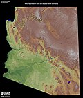
Caliente Range is a west-east trending zone of uplift mountains in the California Coast Ranges, in central California. The highest peak of the range is...
4 KB (401 words) - 02:02, 23 August 2023
Look up caliente in Wiktionary, the free dictionary. Caliente may refer to: Caliente (Calle Ciega album), 2000 Caliente (Vox Dei album) "Caliente" (Dyland...
2 KB (241 words) - 01:25, 13 January 2023
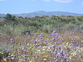
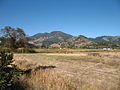
Caliente Mountain is a mountain located in the Southern Coast Ranges of California and is a federally listed wilderness study area for more than 30 years...
2 KB (137 words) - 02:02, 23 August 2023
Coast Ranges, and California mule deer occupy inland and southernmost portions of the Southern Coast Ranges. Bald Hills Berkeley Hills Caliente Range Chalk...
15 KB (1,501 words) - 04:24, 23 February 2024

California Santa Lucia Range, Central California Temblor Range, Central California Caliente Range, Central California Transverse Ranges, Southern California...
17 KB (1,775 words) - 14:24, 15 June 2024
Calico Peaks Caliente Range Call Mountains Calumet Mountains Campbell Hills Capay Hills Cargo Muchacho Mountains Carson Range Cascade Range Casmalia Hills...
13 KB (1,166 words) - 22:52, 4 September 2024
Aguas Calientes (volcano), a volcano in Chile Agua Caliente, Arizona Agua Caliente Mountains, a small range in southwest Arizona Agua Caliente Regional...
3 KB (394 words) - 23:24, 1 November 2023

Carrizo Plain (category Temblor Range)
the Temblor Range, on the other side of which is California's Central Valley. Bordering the plain to the southwest is the Caliente Range. The community...
42 KB (4,878 words) - 00:03, 15 August 2024

annual plant species compose color patches of the hills (Temblor Range and Caliente Range) and the valley floor (Soda Lake). Dominant color patches of hills...
12 KB (1,117 words) - 10:15, 5 September 2024

Caliente /kæliˈɛnti/, formerly known as Culverwell and Calientes, is a city in Lincoln County, Nevada, United States. The population was 1,130 at the 2010...
17 KB (1,215 words) - 01:39, 12 August 2024

Cuyama Valley (category California Coast Ranges)
the south and west, La Panza Range on the north, and Caliente Range along the northeast − all of the California Coast Ranges System; and the San Emigdio...
12 KB (1,406 words) - 05:02, 5 May 2024

Ojo Caliente Hot Springs is a group of thermal springs located in Taos County, New Mexico, United States. They are also known as the Ojo Caliente Mineral...
11 KB (1,189 words) - 17:32, 21 July 2024

Range designated national monument". U.S. Army. March 21, 2023. Retrieved March 22, 2023. "A Proclamation on the Establishment of the Castner Range National...
144 KB (3,827 words) - 18:59, 23 August 2024
Mount Pinos (category Transverse Ranges)
northern Ventura county, much of the Santa Barbara County mountains, the Caliente Range and the Carrizo Plain. The trace of the San Andreas Fault, clearly visible...
12 KB (1,316 words) - 20:48, 1 July 2024

Los Padres National Forest (category California Coast Ranges)
California coastline. Other mountain ranges within the Los Padres include the Santa Lucia Mountains, La Panza Range, Caliente Range (a small part), Sierra Madre...
24 KB (2,290 words) - 02:20, 22 January 2024

towns of Caliente and Tonopah via Rachel, which ascended Cedar Pass and crossed through the northern part of the future Tonopah Test Range. In 1940,...
15 KB (1,708 words) - 19:51, 6 September 2024
Field. On the north during this stretch is the mile-high Caliente Range, which contains Caliente Mountain, the highest peak in San Luis Obispo County. After...
10 KB (896 words) - 06:33, 26 February 2024

The Agua Caliente Casino is a gambling facility, run by the Agua Caliente Band of Cahuilla Indians, in Rancho Mirage, California. The facility has over...
3 KB (201 words) - 14:49, 26 August 2024
Mountain - Peakbagger.com". www.peakbagger.com. Retrieved 2024-05-21. "Caliente Mountain - Peakbagger.com". www.peakbagger.com. Retrieved 2024-05-21. "Yuba...
39 KB (958 words) - 05:09, 1 July 2024

Mercury Comet (redirect from Mercury Caliente)
subseries names. Mercury's mid-sized line-up ranged from the basic Comet 202, through the Capri, Caliente, Cyclone, and Cyclone GT models, as well as steel-sided...
30 KB (3,232 words) - 06:58, 29 July 2024

through the 45-mile-long (72 km) Cuyama Valley, which lies between the Caliente Range and the Sierra Madre Mountains. The river flows past the towns of Cuyama...
8 KB (555 words) - 04:39, 24 May 2024
The Agua Caliente Mountains are a small range in eastern Yuma and western Maricopa counties in southwest Arizona. The community of Hyder is on the north...
2 KB (120 words) - 04:52, 13 November 2021

Rangeland (redirect from Cattle range)
Savannah in southern Africa Caliente Peak, California Lake Swan, Nevada Applied ecology Coastal plain Coastal prairie Experimental range Field Forage Grassland...
28 KB (2,976 words) - 20:16, 28 August 2024
ranges, or Arizona transition zone ranges. Northern and northeast Arizona also has scattered ranges throughout. Agua Caliente Mountains–Yuma County and Maricopa...
35 KB (2,963 words) - 01:15, 17 September 2022
Mayacamas Mountains (redirect from Mayacamas range)
the title and on the diseños of the Rancho Mallacomes y Plano de Agua Caliente or Moristul land grant, dated September 3, 1841, and October 11 and 14...
9 KB (577 words) - 18:39, 29 May 2024
A year later, the new Agua Caliente Racetrack joined the complex. During the eight years it operated, the Agua Caliente hotel, casino and spa achieved...
90 KB (9,342 words) - 03:59, 13 September 2024

Aguas Calientes Volcano or Cerro Aguas Calientes, also called Simba, is a cone-shaped stratovolcano located 5 kilometres (3 mi) east of the Lascar volcano...
10 KB (893 words) - 06:50, 8 July 2024

approximately northwest to southeast, beginning at Whiterock Bluff in the Caliente Range, crossing under the Cuyama River, and ending in the foothills of the...
12 KB (1,561 words) - 01:30, 3 April 2024

altitude, but as a general rule the land can be divided into the tierra caliente (hot land) of river valleys and basins below 1,000 m; the more temperate...
4 KB (296 words) - 14:31, 22 August 2023
Aguas Calientes is a major Miocene caldera in Salta Province, Argentina. It is in the Central Volcanic Zone of the Andes, a zone of volcanism covering...
17 KB (2,063 words) - 19:48, 23 May 2024