
Cape Colbeck Cape Colbeck is a prominent ice-covered cape which forms the northwestern extremity of the Edward VII Peninsula and Marie Byrd Land in Antarctica...
2 KB (190 words) - 21:18, 14 November 2021
William Henry Colbeck (1823–1901), New Zealand politician Cape Colbeck in Antarctica Colbeck, Ontario Colbeck Archipelago in Antarctica Colbeck Basin in Antarctica...
1 KB (141 words) - 02:38, 22 April 2023

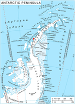
Southern Ocean in Antarctica. The northwest extremity of the peninsula is Cape Colbeck. Edward VII Peninsula is located at 77°40′S 155°00′W / 77.667°S 155...
3 KB (305 words) - 02:38, 30 January 2024
undersea basin of the central Ross Ice Shelf named in association with Cape Colbeck. The name was approved by the Advisory Committee for Undersea Features...
398 bytes (69 words) - 22:03, 21 November 2015

William Colbeck was a British seaman who distinguished himself on two Antarctic expeditions. William Colbeck was born on 8 August 1871, at Myton Place...
8 KB (884 words) - 15:04, 30 April 2024

Cape Crozier Cape Crozier (77°31′S 169°24′E / 77.517°S 169.400°E / -77.517; 169.400) is the most easterly point of Ross Island in Antarctica. It was...
13 KB (1,571 words) - 04:48, 29 May 2024

Cape Adare Cape Adare is a prominent cape of black basalt forming the northern tip of the Adare Peninsula and the north-easternmost extremity of Victoria...
12 KB (1,269 words) - 21:50, 28 June 2024

Major breeding colonies were located at Cape Washington, Coulman Island in Victoria Land, Halley Bay, Cape Colbeck, and Dibble Glacier. Colonies are known...
67 KB (8,154 words) - 07:37, 9 September 2024

Snow Hill Island (redirect from Cape Lázara)
northeast extremity. The northernmost point of Snow Hill Island is Cape Lázara. The cape was named "Cabo Costa Lázara" by the command of the Argentine ship...
10 KB (1,280 words) - 16:38, 12 April 2024
Murray Island (Antarctica) (redirect from Cape Murray (Graham Land))
from the mainland, proving its insularity. It was named in association with Cape Murray, the seaward extremity of the island. A 98 hectares (240 acres) ice-free...
5 KB (556 words) - 15:26, 26 May 2024
Dream Island is an island lying 0.7 km (0.43 mi) south-east of Cape Monaco, off the south-west coast of Anvers Island in Wylie Bay, in the Palmer Archipelago...
4 KB (295 words) - 03:37, 27 July 2024
Island Bernacchi Head Cape Crozier Caughley Beach Franklin Island southwest McDonald Beach Rocky Point King Edward VII Land Cape Colbeck Marie Byrd Land Brownson...
3 KB (228 words) - 18:38, 7 June 2024

in width, with a maximum length of 37 km (23 mi), between Cape Freeman in the north and Cape Smyth in the south. It is mostly covered by ice and snow throughout...
4 KB (301 words) - 19:26, 5 January 2024

Cape Denison Cape Denison is a rocky point at the head of Commonwealth Bay in George V Land, Antarctica. It was discovered in 1912 by the Australasian...
9 KB (1,061 words) - 21:44, 26 April 2022

of chinstrap penguins, as well as over 18,000 pairs of southern fulmars. Cape Plenty List of Antarctic and subantarctic islands "Gibbs Island East". BirdLife...
3 KB (225 words) - 11:19, 20 March 2024
Trinity Island (redirect from Cape Wollaston)
Island in the South Shetland Islands, and 10.3 km (6 mi) north-northwest of Cape Andreas on the Antarctic Peninsula. The island was named by Otto Nordenskiöld...
12 KB (1,493 words) - 14:16, 18 May 2024

Island Bernacchi Head Cape Crozier Caughley Beach Franklin Island southwest McDonald Beach Rocky Point King Edward VII Land Cape Colbeck Marie Byrd Land Brownson...
2 KB (234 words) - 00:43, 20 February 2023
Smith Peninsula (redirect from Cape Fiske)
to Keller Inlet. The Hutton Mountains are to the north of the peninsula. Cape Fiske is the easternmost point. The Smith Peninsula was photographed from...
6 KB (823 words) - 04:03, 29 June 2024

Cape Washington is a prominent cape, 275 m (902 ft), marking the south extremity of the cove which separates Wood Bay and Terra Nova Bay, in Victoria...
2 KB (241 words) - 07:32, 27 November 2022

Island Bernacchi Head Cape Crozier Caughley Beach Franklin Island southwest McDonald Beach Rocky Point King Edward VII Land Cape Colbeck Marie Byrd Land Brownson...
8 KB (780 words) - 17:26, 29 July 2024
He died off the Cape of Good Hope in HMS Ormonde during World War I, in which he had been awarded the Military Cross. Toby Colbeck at ESPNcricinfo "Cricketers...
1 KB (77 words) - 18:33, 25 November 2023

as about 550 pairs of gentoo penguins. Other birds nesting there include cape petrels, Wilson's storm petrels and kelp gulls. Weddell seals regularly haul...
5 KB (485 words) - 22:37, 20 October 2022
wintered at Cape Adare. In 1912, that group (composed of six men in total), began the long journey homewards and began making their way to Cape Evans (via...
8 KB (848 words) - 17:35, 14 February 2024

Island Bernacchi Head Cape Crozier Caughley Beach Franklin Island southwest McDonald Beach Rocky Point King Edward VII Land Cape Colbeck Marie Byrd Land Brownson...
3 KB (295 words) - 10:50, 27 March 2022

mainland Antarctica by the United States Antarctic Service and was named Cape Smyley. In 1968 it was identified as an island on a U.S. Geological Survey...
3 KB (251 words) - 05:58, 23 May 2024

Island Bernacchi Head Cape Crozier Caughley Beach Franklin Island southwest McDonald Beach Rocky Point King Edward VII Land Cape Colbeck Marie Byrd Land Brownson...
6 KB (475 words) - 16:59, 6 April 2024
Cape Evensen is a cape forming the north side of the entrance to Auvert Bay, on the northwest coast of Stresher Peninsula, Graham Land in Antarctica. It...
2 KB (179 words) - 15:39, 8 August 2024

Cape Bienvenue is a small rocky cape which is partially ice-covered, 44 m, forming the east side of the entrance to Piner Bay. Photographed from the air...
2 KB (183 words) - 21:39, 26 April 2022

Cape Davidson is a cape which marks the southernmost part of Mackenzie Peninsula and the west side of the entrance to Wilton Bay, in the west part of...
2 KB (173 words) - 09:02, 15 June 2022
Island Bernacchi Head Cape Crozier Caughley Beach Franklin Island southwest McDonald Beach Rocky Point King Edward VII Land Cape Colbeck Marie Byrd Land Brownson...
7 KB (871 words) - 18:16, 14 July 2024