
Champoeg Creek is a tributary, roughly 6 miles (9.7 km) long, of the Willamette River in the U.S. state of Oregon. The creek is formed by the confluence...
5 KB (322 words) - 09:00, 31 January 2023

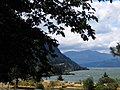
Champoeg (/ʃæmˈpuːiː/ sham-POO-ee, historically /ʃæmˈpuːɛɡ/ sham-POO-eg) is a former town in the U.S. state of Oregon. Now a ghost town, it was an important...
12 KB (997 words) - 18:14, 18 December 2023

Mission Creek is a tributary, roughly 9 miles (14 km) long, of Champoeg Creek in Marion County in the U.S. state of Oregon. The creek arises southwest...
4 KB (262 words) - 19:41, 10 May 2020

miles (0.75 km2), all of it land. The city is near Mission Creek, a tributary of Champoeg Creek, which flows into the Willamette River. As of the census...
18 KB (1,664 words) - 00:57, 27 April 2024

Corral Creek Middle Fork Corral Creek South Fork Corral Creek Ryan Creek Champoeg Creek Mission Creek Case Creek Murphy Creek East Fork Champoeg Creek West...
97 KB (11,400 words) - 07:31, 5 March 2024

Greenway on the left, and Champoeg State Park, on the right. Champoeg Creek enters from the right at RM 45 (RK 72) and Ryan Creek from the right less than...
41 KB (5,128 words) - 18:21, 28 March 2024

Multnomah Falls (redirect from Multnomah Creek Bridge)
Multnomah Falls is a waterfall located on Multnomah Creek in the Columbia River Gorge, east of Troutdale, between Corbett and Dodson, Oregon, United States...
24 KB (2,441 words) - 04:28, 3 July 2024
by the backwaters from the John Day Dam Celilo, flooded by Lake Celilo Champoeg, destroyed by the Great Flood of 1862 Copper, under Applegate Reservoir...
22 KB (1,707 words) - 14:16, 16 April 2024

this period were likely phreatic (steam explosions). Josiah Parrish in Champoeg, Oregon witnessed Mount St. Helens in eruption on 22 November 1842. Ash...
85 KB (8,809 words) - 02:27, 24 June 2024

(14.0 km) Canyon Trail/Trail of Ten Falls runs along the banks of Silver Creek and by ten waterfalls, from which the park received its name. Four of the...
24 KB (1,741 words) - 19:52, 1 December 2023

George Rogers Park (redirect from Oswego Creek Bridge)
Champoeg." in 1850, Albert Alonzo Durham and his wife Miranda filed a Donation Land Claim on 640 acres that included the river landing and the creek ...
14 KB (1,330 words) - 14:20, 11 September 2023

The Opal Creek Wilderness is a wilderness area located in the Willamette National Forest in the U.S. state of Oregon, on the border of the Mount Hood...
7 KB (609 words) - 06:08, 26 June 2022
Pleasant M. Armstrong (category Champoeg Meetings)
sailed to California to exchange for cattle, and voted at the May 2, 1843, Champoeg Meeting. Armstrong immigrated to the Oregon Country in 1840. In 1842, he...
3 KB (296 words) - 14:59, 18 April 2024

Creek Inn State Heritage Site is a state park in the U.S. state of Oregon, administered by the Oregon Parks and Recreation Department. The Wolf Creek...
4 KB (282 words) - 01:46, 3 August 2023

Rogue River Wars (redirect from Battle of Grave Creek)
also: Battle of Evans Creek) Miners began prospecting for gold in the watershed, including a Bear Creek tributary called Jackson Creek, where they established...
17 KB (2,023 words) - 20:10, 24 January 2024
Starvation Creek has a small waterfall and a trailhead for hiking. Starvation Creek Waterfall Starvation Creek Cascade Upper Starvation Creek Falls Mosier...
2 KB (138 words) - 01:38, 3 August 2023

Forest Park (Portland, Oregon) (section Creeks)
are Balch Creek, Rocking Chair Creek, Saltzman Creek, Doane Creek, and Miller Creek. Rocking Chair Creek is a tributary of Saltzman Creek. After leaving...
48 KB (5,127 words) - 16:10, 7 July 2024

Umpqua people (section Cow Creek Band of Upper Umpqua)
Creek, and Cow Creek, the Cow Creek people were called Cow Creek Takelma, or The Cow Creek Band. Today, the Cow Creek Band of Upper Umpqua are represented...
10 KB (1,110 words) - 19:52, 29 May 2024

The Tryon Creek State Natural Area is a state park located primarily in Portland, in the U.S. state of Oregon. It is the only Oregon state park within...
9 KB (941 words) - 15:58, 21 June 2024

later Creek town built with mounds and functioning as part of the Southeastern ceremonial complex. However, there were other traditional Creek "mother-towns"...
123 KB (5,049 words) - 05:09, 30 June 2024

Barr Creek Falls, is a waterfall located in the Rogue River Canyon within the Prospect State Scenic Viewpoint in Jackson County, in the U.S. state of...
4 KB (494 words) - 02:08, 4 January 2021

Warren Creek Falls was a waterfall located in Starvation Creek State Park at the north skirt of the Columbia River Gorge, in Hood River County in the...
3 KB (262 words) - 23:53, 3 August 2020

Starvation Creek Viento Vinzenz Lausmann Wyeth Wygant Willamette Valley Alderwood Bald Peak Blachly Mountain Forest Bowers Rock Cascadia Champoeg Detroit...
10 KB (1,184 words) - 06:39, 8 April 2024

Establishing a land claim in Champoeg, he began removing brush and that summer set off a burn to clear debris. The Champoeg Fire got out of control and...
18 KB (1,422 words) - 18:20, 16 November 2023

Eagle Cap Wilderness (section Eagle Creek)
(43 km) of Eagle Creek from its output at Eagle Lake in the wilderness to the Wallowa–Whitman National Forest boundary at Skull Creek are designated Wild...
17 KB (1,487 words) - 07:21, 26 June 2024
Oregon Rangers (section Battle Creek Incident)
the band, under the command of Robinson, near what became known as Battle Creek in Marion County, Oregon. A short skirmish ensued with one Ranger collapsing...
9 KB (911 words) - 00:44, 27 April 2024

west bank of the Willamette River near the mouth of Chehalem Creek, opposite of Champoeg. Young's home is believed to be the first house built by European-Americans...
10 KB (875 words) - 18:18, 1 January 2021

Mission was elected supreme judge. Babcock chaired two meetings in 1842 at Champoeg, (halfway between Lee's mission and Oregon City), to discuss wolves and...
197 KB (16,731 words) - 00:51, 4 July 2024

Butte Creek Falls, is a waterfall located on the south east of Scotts Mills, in Marion County, in the U.S. state of Oregon. It totals 78 feet fall in...
1 KB (62 words) - 16:07, 25 November 2023

Umpqua National Forest (section Boulder Creek)
and Old Man. Ancestors of the Umpqua, Southern Molala, Yoncalla, and Cow Creek Band of Umpqua Tribe of Indians lived here before Mount Mazama erupted forming...
9 KB (872 words) - 00:42, 17 April 2024