
Chittagong–Kaptai highway or Kaptai road is a 52 km (32 mi) regional highway located in the division of Chittagong, Bangladesh. This highway passes through...
4 KB (277 words) - 10:57, 23 April 2024
of Chittagong under Chittagong Division. It is in the Pahartali union under Raozan sub-district, by the north side of the Chittagong–Kaptai highway about...
21 KB (1,692 words) - 16:33, 28 August 2024
Rangamati (redirect from Rangamati, Chittagong)
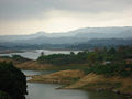
in Chittagong hill tracts. From Chittagong a 77 kilometres (48 mi) road leads to Rangamati. The township is located on the western bank of the Kaptai lake...
11 KB (455 words) - 07:05, 29 August 2024

The Insurgency in the Chittagong Hill Tracts refers to a political and armed conflict that occurred in Bangladesh in two phases: First phase happened from...
38 KB (2,580 words) - 05:05, 31 August 2024

Officer (UNO): Mohammad Arif uddin Chittagong-Rangamati Highway Chittagong-Kaptai Highway Chandraghona-Bandarban Highway Mariamnagar-Ranirhat Link Road Rowazarhat-Ranirhat...
10 KB (827 words) - 17:09, 29 August 2024

List of roads in Bangladesh (redirect from Roads and Highways in Bangladesh)
more than 375,000 km in 2023. Rampura–Demra Expressway Dhaka–Chittagong Expressway Chittagong–Cox’s Bazar Expressway Gabtoli–Nabinagar–Paturia Expressway...
90 KB (220 words) - 19:28, 15 August 2024

were settled in the region after their home in the Chittagong Hill Tracts was flooded by the Kaptai Dam. They make up around a one-third of the district's...
18 KB (1,373 words) - 03:58, 4 August 2024

Industries Development Corporation Forestry Development and Training Centre, Kaptai Bangladesh Forest College Bangladesh Employees Welfare Board (BKKB) Bangladesh...
29 KB (2,275 words) - 14:06, 28 August 2024
Operation Searchlight (section Chittagong)
Ramgarh, Taindong and Sajek, to the north and east of Chittagong. 17th wing had 2 companies at Kaptai and 1 at Rangamati. 11th Wing had a company each at...
143 KB (20,360 words) - 21:51, 30 August 2024

নোয়াখালি সদর) is an upazila of Noakhali District in the Division of Chittagong, Bangladesh. Noakhali Thana was established in 1861 and was converted...
16 KB (907 words) - 12:39, 26 August 2024

Raozan Power Station (redirect from Chittagong Power Station)
(16 mi) north-east from Chattogram on the south side of the Chattogram–Kaptai Highway. It is owned and operated by the state-owned Bangladesh Power Development...
5 KB (434 words) - 20:09, 2 May 2024

Burichang Upazila (category Chittagong Division geography stubs)
23 sq mi).which is located at the extreme near the Upazila by the Dhaka Chittagong Highway. The river Gumti flows through this Upazila. There is a lot of green...
5 KB (389 words) - 04:40, 28 December 2023

Daudkandi Upazila (category Chittagong Division geography stubs)
which is located at the extreme near of the upazila by the Dhaka Chittagong Highway. Daudkandi village area is within the municipality and value of property...
9 KB (499 words) - 20:11, 31 July 2024

Sitakunda Upazila (category Upazilas of Chittagong District)
Economic development in Sitakunda is largely driven by the Dhaka-Chittagong Highway and the railway. Though Sitakunda is predominantly an agricultural...
96 KB (9,362 words) - 17:52, 31 August 2024

autonomous status was revoked by Pakistan, which built the controversial Kaptai Dam that displaced the area's indigenous people. When Bangladesh became...
185 KB (21,231 words) - 05:07, 30 August 2024

Raipur Upazila (category Chittagong Division geography stubs)
Raipur (Bengali: রায়পুর) is an upazila in Lakshmipur District, Chittagong Division, Bangladesh. It is surrounded by the upazilas of Faridganj, Ramganj...
8 KB (592 words) - 00:51, 21 December 2023

Chandina Upazila (category Chittagong Division geography stubs)
is located at the extreme north of the upazila by the N1 or Dhaka-Chittagong Highway. Value of property in the Municipality have increased significantly...
5 KB (316 words) - 20:21, 31 July 2024

Chandanaish Upazila (category Upazilas of Chittagong District)
road in Chandanish Upazila is Chittagong-Cox's Bazar highway. This upazila can be contacted over Barkal Bridge of Chittagong-Anwara District. Can be contacted...
11 KB (894 words) - 16:33, 1 July 2024