
USS Culgoa (AF-3) was a refrigerated supply ship in the United States Navy. Culgoa was built in 1889 by J.L. Thompson and Sons, Ltd. of Sunderland, England...
7 KB (831 words) - 14:00, 13 March 2024

Culgoa is a town in the Mallee region in the north west of the Australian state of Victoria. The town is approximately 319 kilometres (198 mi) from the...
5 KB (276 words) - 05:53, 11 May 2023

HMAS Culgoa (K408/F408/A256), named for the Culgoa River, was a Modified River (or Bay)-class frigate that served in the Royal Australian Navy (RAN)....
4 KB (189 words) - 23:04, 6 May 2023
The Culgoa River is a river that is part of the Darling catchment within the Murray–Darling basin and is located in South West Queensland. The river is...
8 KB (519 words) - 07:22, 28 July 2024
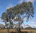
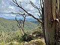
The Culgoa National Park is a protected national park that is located in the north-west region of New South Wales, in eastern Australia. The 35,239-hectare...
5 KB (383 words) - 03:43, 11 January 2024
Culgoa may refer to: Culgoa National Park, north-west New South Wales, Australia Culgoa River, northern New South Wales, Australia Culgoa Floodplain National...
434 bytes (77 words) - 00:48, 6 May 2023

coordinates) Culgoa County is one of the 141 cadastral divisions of New South Wales. It is bounded by the Warrego River in the west, and the Culgoa River in...
8 KB (95 words) - 06:53, 6 August 2024

The Culgoa Floodplain National Park is a protected national park that is located in the South West region of Queensland in eastern Australia. The 42,859-hectare...
4 KB (298 words) - 23:13, 25 December 2023

friendship to Italy by offering aid to its victims. Connecticut, Illinois, Culgoa, and Yankton were dispatched to Messina, Italy, at once. The crew of Illinois...
48 KB (5,382 words) - 02:37, 12 October 2024

Corang Cordeaux Corindi Cowriga Coxs Crawford Crookwell Crudine Cudgegong Culgoa Cullinga Cunningham Curricabark D Darling Great Darling Anabranch Dawson...
84 KB (2,294 words) - 22:11, 7 August 2024

locality is the Culgoa River and the Culgoa Floodplain National Park (28°54′59″S 147°00′40″E / 28.9164°S 147.0111°E / -28.9164; 147.0111 (Culgoa Floodplain...
22 KB (2,076 words) - 02:25, 14 June 2024

the Darling begins between Brewarrina and Bourke at the confluence of the Culgoa and Barwon rivers; streams whose tributaries rise in the ranges of southern...
20 KB (1,869 words) - 04:40, 18 July 2024

speared near the waterholes by a large group of Aboriginal people from the Culgoa River. He attempted to persuade them to move on but they refused, so he...
5 KB (653 words) - 08:59, 26 March 2024

the Barwon and Culgoa Rivers. The Barwon-Darling River system is described as the Barwon River from Mungindi to where it joins the Culgoa River near Brewarrina...
24 KB (2,320 words) - 00:11, 25 August 2024
includes Enngonia on the Warrego River; Brenda, and Weilmoringle on the Culgoa River, as well as Milroy, and south as far as the vicinity of Collerina...
5 KB (495 words) - 04:13, 12 May 2024
Nive River 336 1,102 Warrego Qld 263 163 Culgoa River 109 358 Darling Qld, NSW 489 304 Birrie River 115 377 Culgoa Qld 197 122 Barwon River (New South Wales)...
54 KB (3,950 words) - 22:40, 14 October 2024

Bangladesh (6.6%), Disputed India/China (4.2%), Bhutan (2.4%) 16. Murray–Darling–Culgoa–Balonne–Condamine 3,672 2,282 1,061,000 767 Southern Ocean Australia 17...
54 KB (2,047 words) - 22:36, 25 August 2024
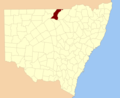
of the 141 cadastral divisions of New South Wales. It is bounded by the Culgoa River on the west, the Narran River in the east, the Queensland border in...
15 KB (179 words) - 06:57, 6 August 2024
Popran Turon Warrumbungle Weddin Mountains Wollemi Far West Brindingabba Culgoa Gundabooka Kalyarr Kemendok Kinchega Koonaburra Mallee Cliffs Mungo Mutawintji...
2 KB (88 words) - 22:44, 24 August 2021
Popran Turon Warrumbungle Weddin Mountains Wollemi Far West Brindingabba Culgoa Gundabooka Kalyarr Kemendok Kinchega Koonaburra Mallee Cliffs Mungo Mutawintji...
3 KB (194 words) - 10:35, 25 January 2024
water storage dams stretch for more than 28 kilometres (17 mi) along the Culgoa River, within the Murray-Darling basin. In an average year the station uses...
13 KB (1,190 words) - 12:33, 7 August 2023
locality is within the Culgoa Floodplain National Park (28°54′59″S 147°00′40″E / 28.9164°S 147.0111°E / -28.9164; 147.0111 (Culgoa Floodplain National...
7 KB (594 words) - 02:03, 11 June 2024

Popran Turon Warrumbungle Weddin Mountains Wollemi Far West Brindingabba Culgoa Gundabooka Kalyarr Kemendok Kinchega Koonaburra Mallee Cliffs Mungo Mutawintji...
2 KB (86 words) - 23:09, 25 December 2023
Popran Turon Warrumbungle Weddin Mountains Wollemi Far West Brindingabba Culgoa Gundabooka Kalyarr Kemendok Kinchega Koonaburra Mallee Cliffs Mungo Mutawintji...
3 KB (119 words) - 15:15, 5 August 2024

Dirranbandi, where it branches, with the western branch then being called the Culgoa River. The eastern branch continues on as the Balonne River through Dirranbandi...
7 KB (529 words) - 09:04, 17 January 2023

Thallon-to-Dirranbandi section of the line was closed on 2 September 2010. The Culgoa Floodplain National Park lies 130 kilometres (81 mi) to the south-west....
30 KB (2,732 words) - 02:42, 9 October 2024
Popran Turon Warrumbungle Weddin Mountains Wollemi Far West Brindingabba Culgoa Gundabooka Kalyarr Kemendok Kinchega Koonaburra Mallee Cliffs Mungo Mutawintji...
23 KB (2,440 words) - 04:11, 12 May 2024
Popran Turon Warrumbungle Weddin Mountains Wollemi Far West Brindingabba Culgoa Gundabooka Kalyarr Kemendok Kinchega Koonaburra Mallee Cliffs Mungo Mutawintji...
4 KB (300 words) - 22:14, 11 January 2024

Popran Turon Warrumbungle Weddin Mountains Wollemi Far West Brindingabba Culgoa Gundabooka Kalyarr Kemendok Kinchega Koonaburra Mallee Cliffs Mungo Mutawintji...
2 KB (56 words) - 11:54, 6 January 2021
Island Swain Reefs Whitsunday Islands South West Alton Chesterton Range Culgoa Floodplain Currawinya Diamantina Hell Hole Gorge Idalia Lake Bindegolly...
2 KB (25 words) - 02:42, 26 April 2020